Excellent Weekend Ahead
About 6 hours of snow will accompany a fast moving upper trough and strong jet stream Thursday afternoon and evening across Star Valley. It should add another 2-4 inches to the current snow pack. While flurries could continue through the night, high pressure and a drier northwesterly flow will lead to one of the better weekends of the Winter. With several inches of new snow on the now substantial snow-pack, outdoor winter sports should be enjoyed under lots of sunshine, particularly Saturday.
The next system will be approaching Star Valley later Sunday into the first of next week. Thus clouds could be on the increase Sunday, however, any new snow should hold off until Sunday night or Monday.
With the clearing skies, overnight temperatures will drop to around zero or below Saturday and again Sunday morning. Inversions will likely develop and keep the valley locations well below freezing. However, winds will be light and sunshine abundant, particularly on Saturday.
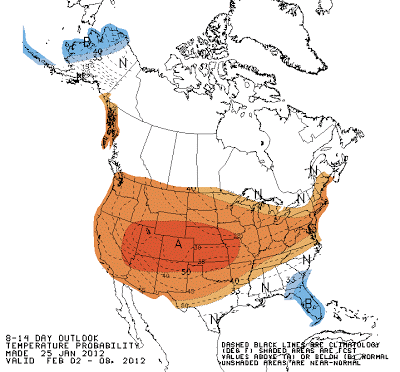
The long range forecast models continue to bring air off the Pacific into Star Valley, rather than out of the Arctic regions of Northern Canada. Bitterly cold air should not be a threat to this area for the foreseeable future.
The latest extended temperature and precipitation forecasts from the Climate Prediction Center certainly support this idea.
 |
||
| Temperature Forecast Feb 2-9 2012 |
 |
| Precipitation Forecast Feb 2-9 2012 |