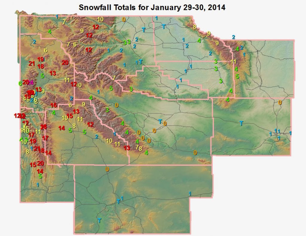
January 29-30 Storm Summary
Heavy snow fell in the mountains of far western Wyoming Wednesday, January 29, and Thursday, January 30. A plume of moisture originating in the tropical Pacific Ocean was matched with significant atmospheric forcing and a favorable wind direction to generate snowfall amounts topping one foot in many mountains locales. The westerly winds are lifted by the north-south mountain ranges of far west Wyoming, which in turn aids snowfall production. The heaviest snow fell across the western mountains and valleys Wednesday and Wednesday evening, before winding down early Thursday. The plume lingered longest over the Salt River and Wyoming mountain ranges of far west-central Wyoming through much of Thursday heping to boost totals in that region. Some valley locations from Thayne to Moose had snowfall totals of 10″ to 12″, while many other valley communities saw totals approaching 6″. The snowfall even extended to the Wind River Mountain foothills around Pinedale and Daniel where snow totals of 4″ to 8″ were observed.
There will be a brief respite from the snowy conditions across the west on Friday before snow chances increase for the weekend and early next week. However, the Arctic origin of this airmass will limit snowfall totals as it will be lacking a warm moisture source. What the pattern does lead to is that western and central Wyoming could see very cold temperatures by the early to middle part of next week.
 |
 |
A view of the 10″+ snowfall at Star Valley Ranch Thursday morning (1/30).
Image courtesy of Jack Hales.
|
The camera shakes in the 50-70 mph wind on Wyoming Boulevard Wednesday afternoon (1/29). Image courtesy of WYDOT. |
 |
|
Snowfall Query
|
Lincoln
|
Station Name
|
Snowfall
|
|
Lincoln
|
Blind Bull Summit Snotel
|
21
|
|
Lincoln
|
Commissary Ridge
|
21
|
|
Lincoln
|
Indian Creek Snotel
|
20
|
|
Lincoln
|
Cottonwood Creek Snotel
|
19
|
|
Lincoln
|
Spring Creek Divide Snotel
|
18
|
|
Lincoln
|
Willow Creek Snotel
|
17
|
|
Lincoln
|
Blind Bull Summit
|
16
|
|
Lincoln
|
Kelley Ranger Station Snotel
|
15
|
|
Lincoln
|
Hams Fork Snotel
|
14
|
|
Lincoln
|
Alpine
|
12
|
|
Lincoln
|
Alpine
|
12
|
|
Lincoln
|
Alpine
|
12
|
|
Lincoln
|
5 NNE Thayne
|
11.7
|
|
Lincoln
|
Box Y Ranch
|
11
|
|
Lincoln
|
Bedford
|
10
|
|
Lincoln
|
Fairview
|
10
|
|
Lincoln
|
2 SE Thayne
|
9.3
|
|
Lincoln
|
Salt River Summit Snotel
|
8
|
|
Lincoln
|
4 ENE Thayne
|
7.5
|
|
Lincoln
|
Star Valley Ranch
|
7
|
|
Lincoln
|
Star Valley Ranch
|
6
|
|
Lincoln
|
21 NNW Kemmerer
|
5
|
|
Lincoln
|
3 W Afton
|
4
|
|
Lincoln
|
3 SE Bedford
|
4
|
|
Lincoln
|
Afton
|
3.3
|
|
Lincoln
|
Fossil Butte
|
1.2
|
|
Lincoln
|
5 SSE Smoot
|
1
|
| County |
|
|
| Big Horn |
Station Name |
Snowfall |
| Big Horn |
Bone Springs Divide Snotel |
9 |
| Big Horn |
Shell Creek Snotel |
9 |
| Big Horn |
Bald Mountain Snotel |
8 |
| Big Horn |
Shell |
3.5 |
| Big Horn |
Basin |
2 |
| Big Horn |
Hyattville |
1.5 |
| Big Horn |
Deaver |
1 |
| Big Horn |
Greybull |
0.7 |
| Fremont |
Station Name |
Snowfall |
| Fremont |
Brooks Lake Lodge |
10 |
| Fremont |
South Pass Snotel |
8 |
| Fremont |
Deer Park Snotel |
7 |
| Fremont |
Castle Creek Snotel |
5 |
| Fremont |
St. Lawrence Alt Snotel |
4 |
| Fremont |
Little Warm Snotel |
4 |
| Fremont |
Hobbs Park Snotel |
4 |
| Fremont |
Townsend Creek Snotel |
4 |
| Fremont |
Atlantic City |
3.5 |
| Fremont |
Cold Springs Snotel |
3 |
| Fremont |
Dubois |
1 |
| Hot Springs |
Station Name |
Snowfall |
| Hot Springs |
Owl Creek Snotel |
3 |
| Hot Springs |
9 NE Thermopolis |
1.1 |
| Hot Springs |
Thermopolis |
0.5 |
| Hot Springs |
Thermopolis |
0.2 |
| Johnson |
Station Name |
Snowfall |
| Johnson |
Bear Trap Meadow Snotel |
5 |
| Johnson |
Cloud Peak Reservoir Snotel |
4 |
| Johnson |
18 E Ten Sleep |
4 |
| Johnson |
Soldier Park Snotel |
2 |
| Johnson |
Little Goose Snotel |
2 |
| Johnson |
Hansen Sawmill Snotel |
1 |
| Johnson |
Buffalo |
0.1 |
| Johnson |
4 SSW Buffalo |
0.1 |
|
|
|
| Natrona |
Station Name |
Snowfall |
| Natrona |
Grave Spring Snotel |
4 |
| Natrona |
Casper |
0.5 to 1 |
| Natrona |
5 SSW Casper |
0.8 |
| Natrona |
10 WSW Casper |
0.8 |
| Natrona |
4 WSW Casper |
0.7 |
| Natrona |
11 ESE Casper |
0.5 |
| Natrona |
11 WSW Casper |
0.3 |
| Park |
Station Name |
Snowfall |
| Park |
Blackwater Snotel |
12 |
| Park |
Wolverine Snotel |
12 |
| Park |
Evening Star Snotel |
12 |
| Park |
Beartooth Lake Snotel |
10 |
| Park |
Kirwin Snotel |
7 |
| Park |
2 WSW Cody |
3 |
| Park |
Cody |
2.9 |
| Park |
Cody |
2.5 |
| Park |
Marquette Snotel |
2 |
| Park |
4 SE Cody |
1.7 |
| Park |
5 ESE Cody |
1.7 |
| Park |
Timber Creek Snotel |
1 |
| Park |
26 SW Cody |
1 |
| Park |
3 NE Sunshine |
0.8 |
| Park |
4 ENE Powell |
0.2 |
| Sublette |
Station Name |
Snowfall |
| Sublette |
Triple Peak Snotel |
17 |
| Sublette |
Loomis Park Snotel |
15 |
| Sublette |
Snider Basin Snotel |
14 |
| Sublette |
Merna |
14 |
| Sublette |
Kendall Ranger Station Snotel |
13 |
| Sublette |
Larsen Creek Snotel |
13 |
| Sublette |
Elkhart Park G.S. Snotel |
12 |
| Sublette |
New Fork Lake Snotel |
11 |
| Sublette |
Big Sandy Opening Snotel |
11 |
| Sublette |
Pocket Creek Snotel |
10 |
| Sublette |
East Rim Divide Snotel |
10 |
| Sublette |
Gunsite Pass Snotel |
9 |
| Sublette |
14 NW Pinedale |
8 |
| Sublette |
Daniel Fish Hatchery |
5 |
| Sublette |
1 N Pinedale |
5 |
| Sublette |
Pinedale |
4.7 |
| Sublette |
Bondurant |
4.4 |
| Sublette |
Pinedale |
4 |
| Sublette |
Boulder Rearing Station |
2 |
| Sublette |
13 SE Pinedale |
0.4 |
| Sweetwater |
Station Name |
Snowfall |
| Sweetwater |
Wamsutter |
1 |
| Sweetwater |
Rock Springs |
0.7 |
| Sweetwater |
Rock Springs |
0.3 |
| Sweetwater |
Green River |
0.3 |
| Teton |
Station Name |
Snowfall |
| Teton |
Grand Targhee Snotel |
24 |
| Teton |
Grassy Lake Snotel |
21 |
| Teton |
Grand Targhee-Chief Joseph |
20 |
| Teton |
Jackson Hole-Raymer |
19 |
| Teton |
Phillips Bench Snotel |
19 |
| Teton |
Snake River Stn Snotel |
18 |
| Teton |
Jackson Hole-Rendezvous Bowl |
18 |
| Teton |
Granite Creek Snotel |
16 |
| Teton |
Jackson Hole-Mid |
14 |
| Teton |
Base Camp Snotel |
13 |
| Teton |
Moose |
12.5 |
| Teton |
Togwotee Pass Snotel |
12 |
| Teton |
Togwotee Mountain Lodge |
11 |
| Teton |
Moose |
10.9 |
| Teton |
2 NE Teton Village |
9.3 |
| Teton |
12 NE Jackson |
9 |
| Teton |
5 NW Jackson |
8.7 |
| Teton |
3 SSW Wilson |
8.5 |
| Teton |
Rafter J Ranch |
8 |
| Teton |
Teton Pass |
8 |
| Teton |
Jackson Hole-Base |
7 |
| Teton |
Gros Ventre Summit Snotel |
6 |
| Teton |
Snow King |
6 |
| Teton |
Moose |
6 |
| Teton |
4 SSW Jackson |
5.6 |
| Teton |
Alta |
5.5 |
| Teton |
Colter Bay |
5 |
| Teton |
Jackson |
4.5 |
| Teton |
Jackson |
3.5 |
| Teton |
2 WSW Jackson |
3 |
| Teton |
Darwin Ranch |
1.9 |
| Teton |
4 SSW Jackson |
1.8 |
| Teton |
Rafter J Ranch |
1.5 |
| Teton |
1 ENE Teton Village |
1.3 |
| Washakie |
Station Name |
Snowfall |
| Washakie |
Powder River Pass Snotel |
11 |
| Washakie |
Middle Powder Snotel |
4 |
| Washakie |
16 SSE Ten Sleep |
2.7 |
| Washakie |
Ten Sleep |
2.7 |
| Washakie |
5 NNW Ten Sleep |
2.7 |
| Washakie |
Worland |
0.5 |
| Washakie |
8 SW Worland |
0.5 |
| Washakie |
Winchester |
0.2 |
| Yellowstone |
Station Name |
Snowfall |
| Yellowstone |
Two Ocean Plateau Snotel |
20 |
| Yellowstone |
Lewis Lake Divide Snotel |
19 |
| Yellowstone |
Parker Peak Snotel |
9 |
| Yellowstone |
Sylvan Lake Snotel |
7 |
| Yellowstone |
Lamar Ranger Station |
7 |
| Yellowstone |
Thumb Divide Snotel |
6 |
| Yellowstone |
Sylvan Road Snotel |
6 |
| Yellowstone |
Canyon Snotel |
4 |
| Yellowstone |
Old Faithful Ranger Station |
2 |
| Yellowstone |
Tower Falls Ranger Station |
1 |
| Yellowstone |
Snake River Ranger Station |
1 |
|

 |
Strongest Winds Tuesday and Wednesday (Jan 28-29)
| County |
Station Name (Elevation) |
Wind Gust (mph) |
| Natrona |
Fales Rock (6380′) |
75 |
| Natrona |
Outer Drive (WYO 258 Wyoming Blvd) |
71 |
| Fremont |
Red Canyon (6768′) |
70 |
| Park |
8 S Clark (4710′) |
69 |
| Fremont |
7 SW Muddy Gap (Camp Creek RAWS 7380′) |
68 |
| Park |
Chief Joseph Highway (8136′) |
65 |
| Park |
5 WNW Clark (4659′) |
63 |
| Fremont |
10 N Dubois (8085′) |
60 |
| Teton |
Summit – Jackson Hole Mountain Resort (10K) |
55 |
| Natrona |
Casper- Natrona County Int’l Airport ASOS |
55 |
| Park |
Hoyt Peak (9800′) |
55 |
| Fremont |
Beaver Rim (6784′) |
55 |
| Johnson |
7 SW Barnum (Poker Creek RAWS 6440′) |
53 |
| Natrona |
Hiland (6134′) |
52 |
| Johnson |
13 NNW Buffalo (4737′) |
52 |
| Fremont |
10 W Ft. Washakie (9235′) |
52 |
| Sweetwater |
15 SE Rock Springs (Snow Springs RAWS 7550′) |
52 |
| Park |
Meeteetse |
52 |
| Johnson |
Buffalo-Johnson County Airport ASOS |
52 |
| Natrona |
19 N Casper (5677′) |
51 |
| Park |
10 WNW Cody (8401′) |
50 |
| Fremont |
Riverton Regional Airport ASOS |
49 |
| Sublette |
21 W Big Piney (8200′) |
49 |
| Fremont |
2 W South Pass City (8185′) |
49 |
| Johnson |
21 ESE Buffalo (4657′) |
48 |
| Sweetwater |
I-80 Milepost 184 |
48 |
| Fremont |
Jeffrey City (6374′) |
48 |
| Fremont |
South Pass (8491′) |
47 |
| Natrona |
7 W Alcova (6342′) |
47 |
| Fremont |
1 WNW Dubois (7014′) |
47 |
| Sweetwater |
Rock Springs-Sweetwater Co. Airport ASOS |
47 |
| Teton |
Raymer – Jackson Hole Mountain Resort |
46 |
| Sweetwater |
5 E Rock Springs (6369′) |
46 |
| Park |
Chief Joseph Highway – Milepost 9 |
46 |
| Fremont |
Lander Hunt Field ASOS |
46 |
| Fremont |
8 W South Pass City (8120′) |
46 |
| Washakie |
S. Bighorn Mountains (6554′) |
46 |
| Johnson |
2 NW Mayoworth (5404′) |
46 |
|
|