Moderate Flooding Potential Still Forecast for Salt River Drainage
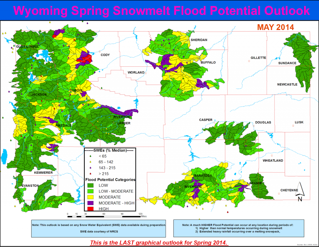
Final 2014 Wyoming Spring Snowmelt Flood Potential Outlook—May 12th
Quick Synopsis:
Above average mountain temperatures in early May caused most of the snow pack (below the 8,500 foot elevation) along basins east of the continental divide having south facing aspects to melt out. Basins west of the continental divide and basins having north facing aspects continue to have normal to above normal snowpack at the 7000 – 8500 foot elevation. The snowpack at the 8,500 to 10,000 foot elevation is still well above average (at 140 to 155% of median) across many basins in Wyoming
Snow water equivalents (SWEs) at 8,500 to 10,000 foot elevations continued to be the highest across basins along the northern third of Wyoming at 140 to160 percent of median. The Upper Green Basin had SWEs at 155 to 170percent of median by May 12th.
This outlook is based on various diverse hydrological factors such as snow water equivalents (SWEs) in the mountain snowpack, basin morphology (i.e. how basins respond to snowmelt), extent of burn scars from 2012 and 2013 fires, amount of bark beetle kill, soil moisture trends, and likely temperature and precipitation trends during peak runoff
HIGHLIGHTS:
…High potential for flooding associated with snowmelt runoff is expected along the South Fork of the Shoshone River downstream of Valley and near the confluence of the Lamar River and Soda Butte Creek in Yellowstone NP…
… Moderate to High potential for flooding associated with snowmelt runoff is forecasted across various headwater streams along the central and southern Big Horn Mountains. Streams with the highest potential for flooding include: Middle Fork of the Powder River (Kaycee), Medicine Lodge Creek, Ten Sleep Creek (Ten Sleep), and Nowood River (Manderson)…
…Moderate to High potential for flooding due to snowmelt is also expected along the Encampment River near Encampment/Riverside and along the North Platte River at Saratoga…
…Moderate to High potential for flooding associated with snowmelt runoff is also forecasted along the Wind River (Crowheart to Riverton) and along the North Fork of the Shoshone River near Wapiti…
…Moderate to High potential for flooding associated with snowmelt runoff is also forecasted along various headwater streams along the upper Green Basin as well as along the Green River near LaBarge…
This is the last graphical outlook for Spring 2014: