The Natural Resources Conservation Service (NRCS) installs, operates, and maintains an extensive, automated system to collect snowpack and related climatic data in the Western United States called SNOTEL (for SNOwpack TELemetry). The system evolved from NRCS’s Congressional mandate in the mid-1930’s “to measure snowpack in the mountains of the West and forecast the water supply.” The programs began with manual measurements of snow courses; since 1980, SNOTEL has reliably and efficiently collected the data needed to produce water supply forecasts and to support the resource management activities of NRCS and others.
Climate studies, air and water quality investigations, and resource management concerns are all served by the modern SNOTEL network. The high-elevation watershed locations and the broad coverage of the network provide important data collection opportunities to researchers, water managers, and emergency managers for natural disasters such as floods.
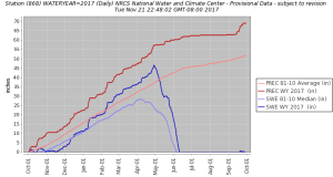
Willow Creek SNOTEL 2016-2017 Snow Water Equivalent/Accumulated Precipitation with 30 year averages
Meteor Burst Technology
SNOTEL uses meteor burst communications technology to collect and communicate data in near-real-time. Satellites are not involved. NRCS operates and control the entire system. Each SNOTEL site transmits a radio signal into the sky, and this signal bounces off a band of ionized meteorites existing about 50 to 80 miles above the earth. This technique allows communication to take place between remote sites and a master station up to 1200 miles away.
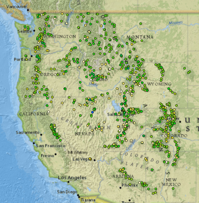
The map below shows the locations of over 730 SNOTEL sites in 11 western states
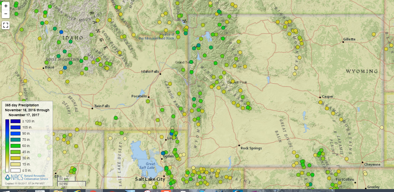
A more detailed map of the Wyoming and surrounding area SNOTEL network is below:
Sites are generally located in remote high-mountain watersheds where access is often difficult or restricted. Access for maintenance by NRCS includes various modes from hiking and skiing to helicopters.
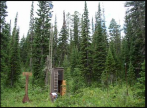
Willow Creek SNOTEL Site
The data from the Willow Creek SNOTEL can be accessed directly on the Starvalleyweather.com home page. At the bottom the Willow Creek link will provide a running total of precipitation for the current water year, along with current snow depth and water content. Also the temperature is recorded.
Sites are designed to operate unattended and without maintenance for a year. They are battery powered with solar cell recharge. The condition of each site is monitored daily when it reports on 8 operational functions. Serious problems or deteriorating performance trigger a response from the NRCS electronic technicians located in 6 Data Collection Offices.
The SNOTEL sites are polled by 2 master stations operated by NRCS in Boise, Idaho, and Ogden, Utah. A central computer at NRCS’s National Water and Climate Center (NWCC) in Portland, Oregon controls system operations and receives the data collected by the SNOTEL network.
New SNOTEL System Capabilities
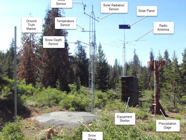
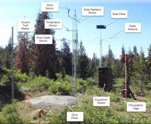
Basic SNOTEL sites have a pressure sensing snow pillow, storage precipitation gage, and air temperature sensor. However, they can accommodate 64 channels of data and will accept analog, parallel, or serial digital sensors. On-site microprocessors provide functions such as computing daily maximum, minimum, and average temperature information. Generally, sensor data is recorded every 15 minutes and reported out in a daily poll of all sites. Special polls are conducted more frequently in response to specific needs.
Above is an example of a typical SNOTEL site.
The new generation of remote sites, master stations, and central computer facilities allows for hourly interrogation of remote sites. The system has the ability to vary the configuration of a remote site by transmitting the appropriate commands telling the remote site what sensors to turn on or what parameters to send. Most of the SNOTEL network uses meteor burst communication technology to send and receive data in near real-time.
At the master station, the remote site data are checked for completeness. If complete, an acknowledgment message, returning over the same path, tells the remote site not to transmit again during this polling period. The entire process takes less than a tenth of a second.
A variety of calculations can be made on any sensor channel. For example, the user can select maximum, minimum, average, standard deviation, or circular averaging.
Each sensor can be accessed independently at a specific interval. For example, wind speed may be sensed every minute during the day to arrive at an average, while the snow pillow may be accessed every 15 minutes for the accumulated total.
System performance has increased over the years, mainly due to a better understanding of meteor burst communication characteristics and improved equipment.
While a 95 percent response to a system- wide poll is the standard, over 99 percent is common.
Data Storage, Management and Accessibility
All data are received by the SNOTEL central computer, which in turn is linked to the Centralized Forecasting System (CFS) in the NWCC where data can be accessed. Once on CFS, the data are in a relational database, where various analysis and graphics programs are available. Current and historical data and analyses are available by dialing in to the CFS, by disk or tape media, paper copy, or more recently via NWCC homepage and internet.
While carrying out the agency mission is paramount, NRCS is interested in supporting the research and operational data collection needs of others. The current system offers excellent opportunities.