Updated-Winter Storm Warning for Much of Western Wyoming
Tuesday has been a snow less day across the Western Wyoming area but that will change in a big way Wednesday and Thursday. A plume of very moist/subtropical air is heading toward the west coast today and will impact Western Wyoming beginning Wednesday. The satellite animation from the GOES-17 this morning clearly shows the moisture plume(atmospheric river) as it heads toward California:
The precipitable water that reflects this moisture plume derived by the computer models can be seen this morning and then again late Wednesday as it heads toward the coast.
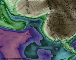
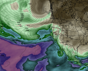
The next couple of days a very active weather map will be ongoing in the Eastern Pacific and Western States which is directing the expected wet period:
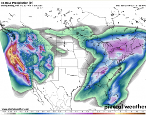
The forecast precipitation totals though Friday morning are substantial in many areas of the Western U.S.
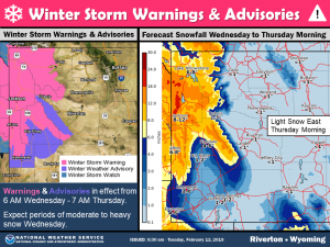
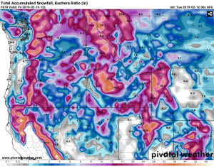
Snowfall amounts in Western Wyoming are expected to be substantial. The temperatures will warm given the source region of the airmass with snow level rising. Still expect mostly snow in Star Valley but it should be a wet snow. Mountains will receive 1-2 feet of new snow by Friday. Here is the model total snow forecast through Friday.
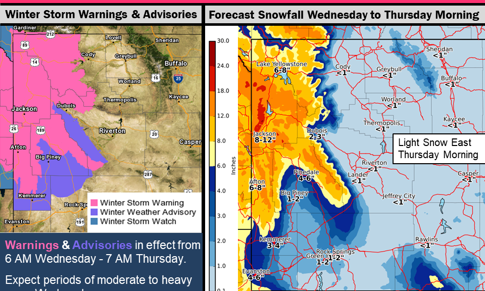
Given the approaching weather system Riverton Forecast Office has issued a Winter Storm Warning
...New Snowstorm to arrive early Wednesday and continue into
Thursday morning in the West...

.A new round of snow will return early Wednesday morning.
Moderate to heavy snow will occur through Wednesday night before
tapering off Thursday morning.


Jackson Hole-Star Valley-
Including the cities of Jackson, Afton, Alpine,
Star Valley Ranch, and Thayne
1047 AM MST Tue Feb 12 2019

...WINTER STORM WARNING IN EFFECT FROM 6 AM WEDNESDAY TO 7 AM MST
THURSDAY...

* WHAT...Heavy snow expected. Total snow accumulations of 5 to
  10 inches expected. Winds gusting as high as 35 mph.

* WHERE...Jackson Hole and Star Valley.

* WHEN...From 6 AM Wednesday to 7 AM MST Thursday. The heaviest
  snow is expected from late Wednesday afternoon into Wednesday
  evening.

* ADDITIONAL DETAILS...Travel could be very difficult. The
  hazardous conditions could impact the morning or evening
  commute.

PRECAUTIONARY/PREPAREDNESS ACTIONS...

A Winter Storm Warning for snow means severe winter weather
conditions will make travel very hazardous or impossible. If you
must travel, keep an extra flashlight, food and water in your
vehicle in case of an emergency.

The latest road conditions for the state you are calling from can
be obtained by calling 5 1 1.