Update on Weekend Snow Storm for the Northern Rockies
Western Wyoming will escape the major snow storm expected in Montana, but snow will fall in all Western Wyoming mountains, reaching the valley floors by Sunday
Historic September Snowstorm Will Bring Blizzard Conditions to Montana, Dumping Over a Foot of Snow
weather.com meteorologists
Published: September 27, 2019
A historic September snowstorm, with blizzard conditions and record cold temperatures possible, will slam parts of the northern Rockies this weekend. In addition, the first snow of the season is expected in some lower elevations of Montana, Wyoming and the western Dakotas just days after the official arrival of fall.
The jet stream will take a sharp, southward plunge from western Canada into the Northwest late this week. That will send temperatures crashing well below average for this time of year.
 A southward plunge of the jet stream will drop temperatures well below average in a large part of the Northwest this weekend. Snow is forecast in the northern Rockies.
Snow will become more widespread later Friday and continue through the weekend in the northern Rockies of Idaho, Montana and Wyoming. Snow will begin to accumulate late Friday or early Saturday morning in higher elevations, then by late Saturday in the valleys where warm summer air still resides.
A second round of lighter snow may blanket parts of the northern Rockies and northern High Plains Monday into Tuesday.
Some lower-elevation cities will see their first measurable snow of the season, including Great Falls and Helena, Montana. That’s not too unusual since the average date of the first snowfall is Oct. 2 in Great Falls and Oct. 12 in Helena. The higher elevations of the northern Rockies have already seen snow earlier in September.
(MORE: When the First Snow Arrives Where You Live)
But this round of snow will be much heavier and more widespread and could impact travel through passes in the region.
The National Weather Service has issued a winter storm warning beginning Friday evening for a part of northern and western Montana and northern Idaho, where extreme impacts are possible. Winter storm watches have also been posted for parts of western and north-central Montana, Idaho and northern Washington.
 Winter Weather Alerts
Wind gusts of 40 to 50 mph are likely at times, with gusts over 60 mph possible in some areas, especially in northwestern Montana.
Destructive winds are likely in passes and also over large open bodies of water such as lakes and marinas. Wind damage is possible throughout the northern Continental Divide.
The strong wording from the NWS office in Great Falls, Montana, Wednesday morning was eye-opening.
“This early-season winter storm and/or blizzard has the potential to set a new benchmark for snow accumulations, cold temperatures and resulting impacts for parts of the northern Rockies and the Rocky Mountain Front,” NWS-Great Falls wrote.
How Much Snow?
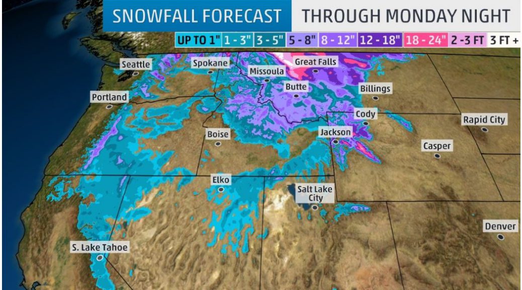
The heaviest snow totals are expected in parts of northern and central Montana, where over a foot of snow is probable. Some of these areas may see multiple feet of snow. Some heavy totals are also expected in other parts of central and western Montana, Idaho and higher elevations of northern and western Wyoming.
Some lower elevations could also see some accumulations of wet snow, particularly on grassy areas, in the northern High Plains of eastern Montana, northeastern Wyoming and perhaps the western Dakotas early next week. Accumulating snow is also expected in the Cascades of Washington and Oregon and high-plateau areas of the Great Basin from Oregon into Nevada, as well as the Sierra in California.
 Snowfall Forecast
Early fall snowstorms are often destructive.
The combination of heavy, wet snow and strong winds this weekend will likely lead to widespread tree damage, power outages and blizzard conditions in parts of Montana, according to the NWS.
Travel in parts of central and western Montana, possibly into northwestern Wyoming, is likely to become dangerous, if not impossible, especially over mountain passes and in open areas where blizzard conditions could quickly reduce visibility. Road closures are likely in some of these areas.
 Five-Day Forecast
Areas with enough snow to last a couple of days will experience melting during the day which will freeze into ice at nice, making for slippery roads and sidewalks in some places, according to NWS-Missoula.
NWS-Great Falls compared the potential of this snowstorm to another storm in late September 1934, which produced over a foot of heavy, wet snow in both Cut Bank and Great Falls, Montana, and over 6 inches of snow in Helena, Montana.
More recently, an early October 2017 snowstorm dumped over a foot of snow, leading to widespread power outages and downed trees in northern Montana, including the city of Havre.
Record Cold
High temperatures are likely to be 10 to 35 degrees below late September averages this weekend from Northern California and northern Nevada to Montana, Idaho and Wyoming.
Daytime temperatures holding in the 30s, 40s or 50s could set daily record-cold highs Saturday through Tuesday in parts of the northern Great Basin and northern Rockies.
 Forecast Highs
Temperatures will plunge below freezing at night in parts of the northern Rockies. Lows will bottom out into the 20s – or perhaps a few upper teens – in the northern Rockies. This will end agricultural seasons in spots that dip below freezing.
Some daily record lows are possible in the West into next week.
Frigid temperatures combined with strong winds may result in dangerous wind chill temperatures in some locations.
 Forecast Morning Lows
(MAPS: 10-Day U.S. Forecast High and Low Temperatures)
This taste of wintry weather during fall’s first weekend will be in stark contrast to the summerlike heat ongoing at the same time in portions of the East.
The Weather Company’s primary journalistic mission is to report on breaking weather news, the environment and the importance of science to our lives. This story does not necessarily represent the position of our parent company, IBM.