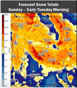
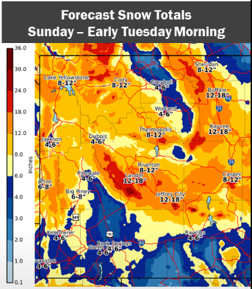
 ...Major Winter Storm likely Sunday Afternoon through Monday
Night...
.A cold front move into northern Wyoming Sunday morning. This
cold front will drop southward to the Continental Divide by
around sunset Sunday and southwest Wyoming Sunday night. The
precipitation is expected to occur behind the cold front. This
storm system will move slowly, with snow lingering through Monday
night. The heaviest snowfall looks to occur Sunday night through
Monday in most locations. Snowfall amounts are still somewhat
uncertain and may be tweaked as the storm draws closer.
Star Valley-Salt River and Wyoming Ranges-
Including the cities of Afton, Alpine, Star Valley Ranch,
and Thayne
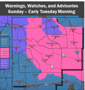
...WINTER STORM WATCH IN EFFECT FROM SUNDAY EVENING THROUGH LATE
MONDAY NIGHT...
* WHAT...Heavy snow possible. Total snow accumulations 5 to 9
inches in the Star Valley; 8 to 15 inches in the Mountains.
* WHERE...Star Valley and Salt River and Wyoming Ranges.
* WHEN...From Sunday evening through late Monday night.
* IMPACTS...Plan on very difficult travel.
* ADDITIONAL DETAILS...Forecasted snow amounts could still change
somewhat as the storm system gets closer and details become
clearer.
PRECAUTIONARY/PREPAREDNESS ACTIONS...
...Major Winter Storm likely Sunday Afternoon through Monday
Night...

.A cold front move into northern Wyoming Sunday morning. This
cold front will drop southward to the Continental Divide by
around sunset Sunday and southwest Wyoming Sunday night. The
precipitation is expected to occur behind the cold front. This
storm system will move slowly, with snow lingering through Monday
night. The heaviest snowfall looks to occur Sunday night through
Monday in most locations. Snowfall amounts are still somewhat
uncertain and may be tweaked as the storm draws closer.


Star Valley-Salt River and Wyoming Ranges-
Including the cities of Afton, Alpine, Star Valley Ranch,
and Thayne

...WINTER STORM WATCH IN EFFECT FROM SUNDAY EVENING THROUGH LATE
MONDAY NIGHT...

* WHAT...Heavy snow possible. Total snow accumulations 5 to 9
  inches in the Star Valley; 8 to 15 inches in the Mountains.

* WHERE...Star Valley and Salt River and Wyoming Ranges.

* WHEN...From Sunday evening through late Monday night.

* IMPACTS...Plan on very difficult travel.

* ADDITIONAL DETAILS...Forecasted snow amounts could still change
  somewhat as the storm system gets closer and details become
  clearer.

PRECAUTIONARY/PREPAREDNESS ACTIONS...