
El Nino-Post Mortem
Dave Steenburgh of the University of Utah discusses the El Nino of 2015-2016 as the winter snows are behind us. The winners and losers. Here in Star Valley it has been about an average snow season thus far but where the real help was needed from El Nino across the Southwest, it has been a disappointment.
Still Waiting for El Nino in the Southwest
Chris Farley always delivered, but even if all other “tropical storms” bow before El Nino, as he suggests above, the 2015/16 “Super” El Nino continues to be a bust for the southwest United States.
Let’s go back to a few months ago when we knew a strong El Nino was likely for this winter. At that time, one could find all sorts of graphics like the one below showing the “typical” wintertime pattern associated with El Nino, including the wet southwest.
 |
| Source: NWS |
Forecasts from the Climate Prediction Center showed the dice loaded for above average precipitation in the southwest.
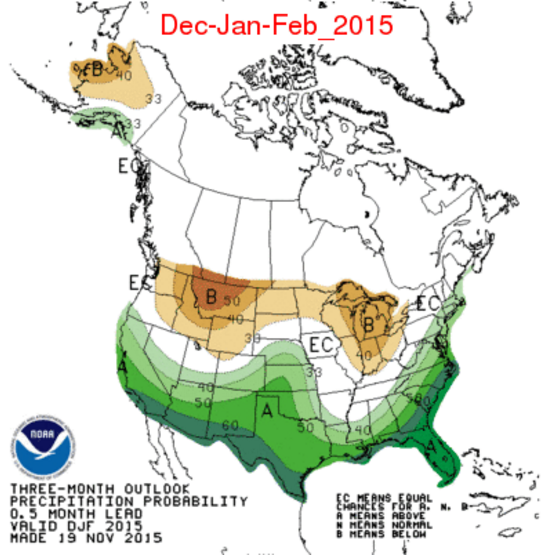 |
| Source CPC |
The fact that this El Nino was going to be strong led some people to believe that the odds of a wet southwest were high, especially since the last two strong events, 82/83 and 98/99 were fairly wet in the southwest.
Let’s fast forward to today. The percent of average precipitation below covers the past 90 days (roughly since just before Christmas). Northern California has done quite well, which is why reservoirs there have recovered, but most of the southwest has been below average during this period.

If we look at snowpack the numbers in the far southwest are really dismal, but even southern Utah, southern Colorado, and northern New Mexico are slipping below average.
 |
| Source: NRCS |
And, if we look at forecasts for the next 10 days, they continue to skunk the southwest. Below for example is the 10-day accumulated precipitation forecast from the GFS. Plenty of action in the north, but little in the south. Rather than El Nino, this looks like a good La Nina pattern.
 |
| Source: NCEP |
It’s time to face facts. First, the skill and utility of seasonal outlooks, whether they show weighting of the odds or pick an outcome (e.g., below average, average, or above average), remains limited for many applications. I suspect we will see improvement in coming years and decades, but where we are in seasonal prediction today is about where we were in weather forecasting in the 1960s and 70s. The models are crude and we’re relying too much on past analogs and human intuition. Ultimately, these outlooks are going to improve, but even then, we must guard against converting those probabilities in to deterministic outcomes (e.g., increased odds of above average precipitation equals above average precipitation). Second, we need to be more cautious about pushing analogs based on past events too far. A few months ago, many people were using the past two super El Ninos as analogs for this coming winter. A sample size of two is simply too small.
Finally, if you are skiing in northern Utah, you should just stop looking at seasonal forecasts altogether. SEASONAL OUTLOOKS ARE UTTERLY AND TOTALLY VALUELESS FOR ANTICIPATING WHAT KIND OF SKI SEASON WE ARE GOING TO HAVE IN NORTHERN UTAH. Next October, don’t waste your time on this stuff. Wax your skis and be happy.