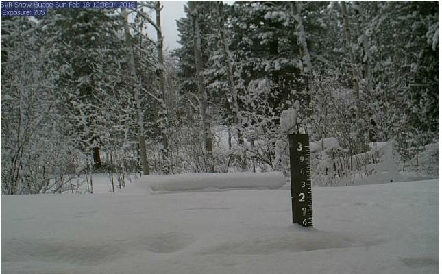
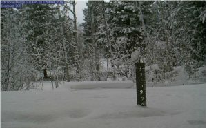
 Star Valley Ranch Snow Cam Sunday Morning
National Weather Service Riverton WY
245 PM MST Sun Feb 18 2018

Snow moved across the region as an Arctic front started to slide
across Western and Central Wyoming today. Snow started to accumulate
by early Saturday afternoon across the northwest and moved southeast
overnight and Sunday morning. The following are preliminary snowfall
reports from around the area through noon Sunday.

Location                              Snowfall

Big Horn County...
 Lovell...                            7 inches.
 Bald Mountain Snotel...              7 inches.
 Bone Springs Divide Snotel...        4 inches.
 2 SSW Lovell...                    2.5 inches.
 1 W Lovell...                        2 inches.
 Shell Creek Snotel...                2 inches.

Fremont County...
 Burroughs Creek Snotel...           11 inches.
 Brooks Lake...                       9 inches.
 Castle Creek Snotel...               7 inches.
 Little Warm Snotel...                7 inches.
 Hobbs Park Snotel...                 4 inches.
 Cold Springs Snotel...               4 inches.
 Dubois...                            4 inches.
 St. Lawrence Alt Snotel...           2 inches.
 South Pass Snotel...                 1 inch.
 Townsend Creek Snotel...             1 inch.
 Deer Park Snotel...                  1 inch.

Hot Springs County...
 Owl Creek Snotel...                  3 inches.
 Thermopolis...                     0.2 inches.

Johnson County...
 Little Goose Snotel...               6 inches.
 Soldier Park Snotel...               5 inches.
 Bear Trap Meadow Snotel...           5 inches.
 Cloud Peak Reservoir Snotel...       5 inches.
 Hansen Sawmill Snotel...             3 inches.
 4 SSW Buffalo...                     1 inch.

Lincoln County...
 Willow Creek Snotel...              11 inches.
 Blind Bull Summit...                 9 inches.
 Spring Creek Divide Snotel...        9 inches.
 Indian Creek Snotel...               8 inches.
 Star Valley Ranch...                 6 inches.
 Hams Fork Snotel...                  6 inches.
 Commissary Ridge...                  6 inches.
 Cottonwood Creek Snotel...           5 inches.
 Kelley Ranger Station Snotel...      5 inches.
 Star Valley Ranch...                 4 inches.
 Salt River Summit Snotel...          4 inches.
 Blind Bull Summit Snotel...          4 inches.
 Afton...                             3 inches.
 2 SE Thayne...                     2.5 inches.
 3 SE Bedford...                      2 inches.
 5 SSE Smoot...                       1 inch.
 Box Y Ranch...                       1 inch.

Natrona County...
 Grave Springs Snotel...              2 inches.
 Reno Hill Snotel...                  1 inch.

Park County...
 Beartooth Lake Snotel...            14 inches.
 Evening Star Snotel...              13 inches.
 7 NW Cody...                      11.1 inches.
 Blackwater Snotel...                11 inches.
 Kirwin Snotel...                     8 inches.
 Wolverine Snotel...                  8 inches.
 Pahaska...                           5 inches.
 2 WSW Cody...                      3.5 inches.
 Marquette Snotel...                  3 inches.
 Cody...                              3 inches.
 4 SW Powell...                     2.5 inches.
 4 SE Cody...                       2.4 inches.
 Timber Creek Snotel...               2 inches.
 4 ENE Powell...                      2 inches.
 Powell...                              1 inch.
 26 SW Cody...                          1 inch.
 3 NE Sunshine...                   0.2 inches.

Sublette County...
 Triple Peak Snotel...               10 inches.
 Kendall Ranger Station Snotel...     7 inches.
 East Rim Divide Snotel...            6 inches.
 Gunsite Pass Snotel...               6 inches.
 Snider Basin Snotel...               5 inches.
 Loomis Park Snotel...                4 inches.
 New Fork Lake Snotel...              4 inches.
 Elkhart Park G.S. Snotel...          2 inches.
 14 NW Pinedale...                  1.8 inches.
 Big Sandy Opening Snotel...          1 inch.
 Pocket Creek Snotel...               1 inch.
 Larsen Creek Snotel...               1 inch.

Sweetwater County...

Teton County...
 Jackson Hole - Raymer...            12 inches.
 Granite Creek Snotel...             11 inches.
 Phillips Bench Snotel...            11 inches.
 Togwotee Pass Snotel...             10 inches.
 Jackson Hole - Rendezvous Bowl...    9 inches.
 Snake River Stn Snotel...            9 inches.
 Gros Ventre Summit Snotel...         8 inches.
 Snow King...                         7 inches.
 1 ENE Teton Village...             6.5 inches.
 Jackson Hole - Mid Mountain...       6 inches.
 Jackson Hole - Base...               6 inches.
 Togwotee Mountain Lodge...           6 inches.
 Grassy Lake Snotel...                6 inches.
 Base Camp Snotel...                  6 inches.
 Grand Targhee - Chief Joseph...      5 inches.
 Grand Targhee Snotel...              1 inch.

Washakie County...
 Middle Powder Snotel...              2 inches.
 Powder River Pass Snotel...          1 inch.

Yellowstone National Park...
 Two Ocean Plateau Snotel...         11 inches.
 Canyon Snotel...                    10 inches.
 Thumb Divide Snotel...               9 inches.
 Sylvan Lake Snotel...                8 inches.
 Parker Peak Snotel...                8 inches.
 Lamar Ranger Station...              5 inches.
 Lewis Lake Divide Snotel...          5 inches.
 Sylvan Road Snotel...                4 inches.