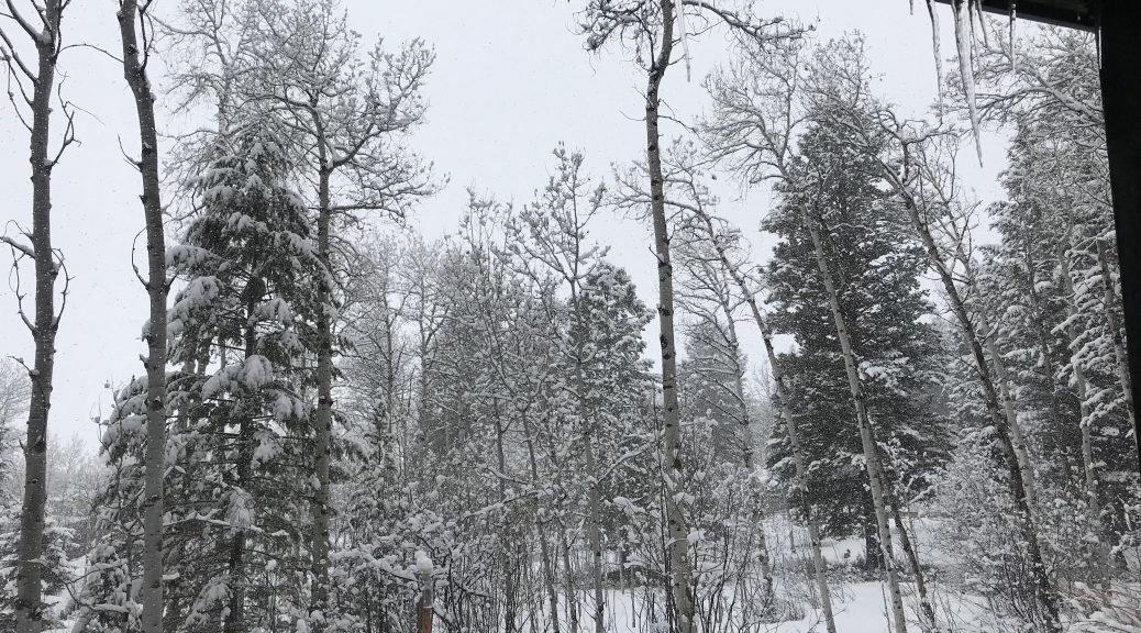
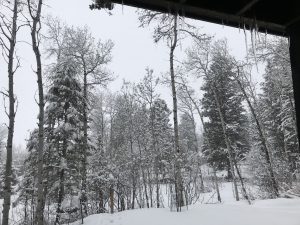
 Star Valley Ranch
 24 hour snowfall 8am Thursday April 15 2020
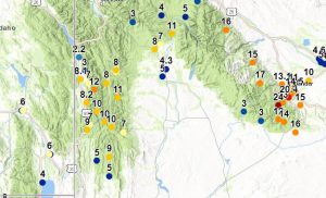
National Weather Service Riverton WY
0939 AM MDT Thu Apr 16 2020

A mid-April winter storm has brought a fresh layer of snowfall to
much of the state. Highest snowfall amounts were generally across
Fremont County and across higher elevations. Below are preliminary
snowfall totals from Wednesday night through 8 am Thursday morning.

Note: SnoTELS (Snow Telemetry) are remote sensing sites in high
mountain watersheds. Snowfall data from SNOTELS are estimated based
on snow water equivalent.
Location                              Snowfall

Big Horn County...
 Bone Springs Divide Snotel...        2 inches.
 Bald Mountain Snotel...              2 inches.
 Shell Creek Snotel...                1 inch.
 Greybull...                        0.3 inches.

Fremont County...
 Townsend Creek Snotel...            24 inches.
 6 SW Lander...                    20.4 inches.
 Hobbs Park Snotel...                17 inches.
 Atlantic City...                    16 inches.
 Cold Springs Snotel...              16 inches.
 9 SSE Lander...                     15 inches.
 St. Lawrence Alt Snotel...          15 inches.
 Lander...                         14.5 inches.
 South Pass Snotel...                14 inches.
 Lander Airport...                   14 inches.
 3 SW Lander...                      14 inches.
 7 WNW Lander...                   13.1 inches.
 9.5 SW Lander...                    13 inches.
 Deer Park Snotel...                 12 inches.
 1 N Lander...                       11 inches.
 9 SSE Lander...                   10.3 inches.
 Hudson...                           10 inches.
 Brooks Lake...                       6 inches.
 4 W Riverton...                      5 inches.
 Riverton Airport...                4.6 inches.
 Sweetwater Station...              4.2 inches.
 Burroughs Creek Snotel...            4 inches.
 2 W Riverton...                      4 inches.
 Jeffrey City...                       4 inches.
 Riverton...                          4 inches.
 Little Warm Snotel...                3 inches.
 Dubois...                          2.5 inches.
 Castle Creek Snotel...               2 inches.
 Boysen Dam...                        1 inch.

Hot Springs County...
 Owl Creek Snotel...                  6 inches.
 Thermopolis...                       3 inches.
 Lucerne...                         2.5 inches.
 9 NE Thermopolis...                0.7 inches.

Johnson County...
 17 NNW Kaycee...                     8 inches.
 Hansen Sawmill Snotel...             6 inches.
 Little Goose Snotel...               4 inches.
 Cloud Peak Reservoir Snotel...       4 inches.
 Bear Trap Meadow Snotel...           3 inches.
 4 SSW Buffalo...                      3 inches.
 Buffalo...                            2 inches.
 17 E Kaycee...                     1.5 inches.
 13 SSE Buffalo...                   1.5 inches.
 Soldier Park Snotel...               1 inch.

Lincoln County...
 Willow Creek Snotel...              12 inches.
 Commissary Ridge...                 10 inches.
 Spring Creek Divide Snotel...       10 inches.
 Cottonwood Creek Snotel...          10 inches.
 Salt River Summit Snotel...          9 inches.
 Indian Creek Snotel...               9 inches.
 Afton...                           8.2 inches.
 2 SE Thayne...                     8.1 inches.
 Blind Bull Summit...                 8 inches.
 Box Y Ranch...                       8 inches.
 Blind Bull Summit Snotel...          7 inches.
 5 SSE Smoot...                       7 inches.
 3 SE Bedford...                      7 inches.
 Hams Fork Snotel...                  5 inches.
 Kelley Ranger Station Snotel...      5 inches.
 Star Valley Ranch...                 4 inches.
 3 N Etna...                        2.2 inches.
 Fossil Butte...                    1.3 inches.

Natrona County...
 Reno Hill Snotel...                 10 inches.
 Casper Mountain Snotel...           10 inches.
 1 SW Casper...                       5 inches.
 1 S Casper...                        4 inches.
 Casper Airport...                  3.4 inches.
 4 WSW Casper...                    3.2 inches.
 Grave Springs Snotel...              3 inches.
 Powder River...                      3 inches.
 Casper...                          2.5 inches.
 Casper...                            2 inches.

Park County...
 Marquette Snotel...                 18 inches.
 Timber Creek Snotel...              12 inches.
 Wolverine Snotel...                  6 inches.
 Blackwater Snotel...                 4 inches.
 Pahaska...                           4 inches.
 Evening Star Snotel...               3 inches.
 Younts Peak Snotel...                3 inches.
 Kirwin Snotel...                     3 inches.
 2 SE Meeteetse...                  1.4 inches.
 3 NE Sunshine...                   1.4 inches.
 3 NE Clark...                        1 inch.
 2 WSW Cody...                        1 inch.
 Beartooth Lake Snotel...             1 inch.

Sublette County...
 Triple Peak Snotel...               11 inches.
 Kendall Ranger Station Snotel...    11 inches.
 East Rim Divide Snotel...            8 inches.
 Snider Basin Snotel...               7 inches.
 Loomis Park Snotel...                7 inches.
 Daniel Fish Hatchery...              5 inches.
 Gunsite Pass Snotel...               5 inches.
 14 NW Pinedale...                  4.3 inches.
 Big Sandy Opening Snotel...          3 inches.
 Larsen Creek Snotel...               3 inches.
 Boulder Rearing Station...           2 inches.
 Elkhart Park G.S. Snotel...          2 inches.
 5 SE Pinedale...                   1.5 inches.
 Bondurant...                       1.4 inches.
 New Fork Lake Snotel...              1 inch.

Sweetwater County...
 Rock Springs...                      5 inches.
 4 NNW Rock Springs...                5 inches.
 Wamsutter...                         4 inches.
 Green River...                       1 inch.
 Green River...                     0.5 inches.
 Green River...                     0.4 inches.

Teton County...
 Jackson Hole - Rendezvous Bowl...   16 inches.
 Jackson Hole - Raymer...            13 inches.
 Jackson Hole - Mid Mountain...      13 inches.
 6 NW Moose...                       12 inches.
 Grassy Lake Snotel...                6 inches.
 Jackson Hole - Base...               6 inches.
 Togwotee Pass Snotel...              6 inches.
 Base Camp Snotel...                  6 inches.
 Togwotee Mountain Lodge...           5 inches.
 Grand Targhee Snotel...              5 inches.
 Grand Targhee - Chief Joseph...      5 inches.
 Gros Ventre Summit Snotel...         4 inches.
 Granite Creek Snotel...              3 inches.
 1 NNW Alta...                        2 inches.
 2 NE Teton Village...              1.5 inches.
 Jackson Dam...                     1.4 inches.
 3 SSW Wilson...                    0.5 inches.
 Jackson...                         0.3 inches.

Washakie County...
 5 NNW Ten Sleep...                 6.6 inches.
 Ten Sleep...                         6 inches.
 16 SSE Ten Sleep...                  5 inches.
 Powder River Pass Snotel...          3 inches.

Yellowstone National Park...
 Sylvan Road Snotel...                6 inches.
 Two Ocean Plateau Snotel...          4 inches.
 Lewis Lake Divide Snotel...          4 inches.
 Sylvan Lake Snotel...                4 inches.
 Parker Peak Snotel...                4 inches.
 Thumb Divide Snotel...               3 inches.
 Snake River Ranger Station...        2 inches.
 Lamar Ranger Station...            1.5 inches.
 Tower Falls Ranger Station...      0.4 inches.