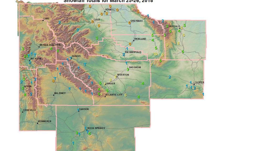
Snowfall March 25-26 2018
Weather Service Riverton WY
717 PM MST Mon Mar 26 2018

...Preliminary Storm Information...

The following are snowfall reports for March 25-26, 2018.

Observations are collected from a variety of sources with varying
equipment and exposures. We thank all volunteer weather observers
for their dedication. Not all data listed are considered official.

***** Snowfall Reports *****

Location                              Snowfall

Big Horn County...
 Shell Creek Snotel...                1 inch.
 Bone Springs Divide Snotel...        1 inch.

Fremont County...
 Riverton...                        9.2 inches.
 South Pass Snotel...                 9 inches.
 Hudson...                            8 inches.
 7 SE Lander...                       8 inches.
 Lander...                          7.5 inches.
 Lander Airport...                    7 inches.
 3 SW Lander...                       7 inches.
 6 SW Lander...                     6.6 inches.
 Riverton Airport...                6.1 inches.
 2 W Riverton...                      6 inches.
 4 W Riverton...                      6 inches.
 7 SE Lander...                       6 inches.
 1 N Lander...                        6 inches.
 Sweetwater Station...                6 inches.
 9 SSE Lander...                    5.4 inches.
 Deer Park Snotel...                  5 inches.
 7 WNW Lander...                    4.8 inches.
 35 ESE Riverton...                   4 inches.
 Townsend Creek Snotel...             4 inches.
 Brooks Lake...                       4 inches.
 Jeffrey City...                      4 inches.
 Shoshoni...                        3.2 inches.
 St. Lawrence Alt Snotel...           2 inches.
 Boysen Dam...                        1 inch.
 Dubois...                            1 inch.
 Hobbs Park Snotel...                 1 inch.
 Little Warm Snotel...                1 inch.
 Cold Springs Snotel...               1 inch.

Hot Springs County...
 Thermopolis...                     1.9 inches.
 9 NE Thermopolis...                0.5 inches.

Johnson County...
 Bear Trap Meadow Snotel...           9 inches.
 17 NNW Kaycee...                     8 inches.
 Buffalo...                         6.2 inches.
 13 SSE Buffalo...                    6 inches.
 Kaycee...                            5 inches.
 Hansen Sawmill Snotel...             5 inches.
 4 SSW Buffalo...                     4 inches.
 7 NE Buffalo...                    3.3 inches.
 Cloud Peak Reservoir Snotel...       3 inches.
 Soldier Park Snotel...               2 inches.
 Little Goose Snotel...               2 inches.

Lincoln County...
 5 SSE Smoot...                       4 inches.
 Afton...                           3.4 inches.
 5 NNE Thayne...                      3 inches.
 2 SE Thayne...                     2.3 inches.
 Blind Bull Summit...                 2 inches.
 Commissary Ridge...                  2 inches.
 Box Y Ranch...                       1 inch.
 Star Valley Ran.ch...                 1 inch
Natrona County...
 12 NE Lysite...                    6.5 inches.
 Grave Springs Snotel...              5 inches.
 Casper Mountain Snotel...            2 inches.
 Powder River...                      2 inches.
 4 WSW Casper...                    1.4 inches.
 Casper...                            1 inch.
 5 SSW Casper...                      1 inch.
 10 WSW Casper...                    1 inch.
 Reno Hill Snotel...                  1 inch.
 Casper Airport...                  0.6 inches.
 11 WSW Casper...                   0.5 inches.
 1 S Casper...                      0.2 inches.

Park County...
 3 NE Sunshine...                   2.5 inches.
 26 SW Cody...                        2 inches.
 Pahaska...                         1.5 inches.

Sublette County...
 New Fork Lake Snotel...              1 inch.
 Pocket Creek Snotel...               1 inch.
 Larsen Creek Snotel...               1 inch.
 Kendall Ranger Station Snotel...     1 inch.
 Boulder Rearing Station...           1 inch.
 Big Sandy Opening Snotel...          1 inch.
 Gunsite Pass Snotel...               1 inch.
 Pinedale...                        0.4 inches.

Sweetwater County...
 7 SE Rock Springs...               3.5 inches.
 Green River...                     2.5 inches.
 Buckboard Marina...                  1 inch.
 4 NNW Rock Springs...                1 inch.
 2 NNE Farson...                    0.5 inches.

Teton County...
 Togwotee Mountain Lodge...           4 inches.
 Jackson Hole - Raymer...             3 inches.
 Grand Targhee - Chief Joseph...      3 inches.
 Jackson Hole - Rendezvous Bowl...    3 inches.
 Jackson Hole - Mid Mountain...       2 inches.
 Snow King...                         2 inches.
 Jackson Hole - Base...               1 inch.
 Moose...                           0.6 inches.
 Jackson Dam...                     0.4 inches.
 2 SW Wilson...                     0.2 inches.

Washakie County...
 27 S Ten Sleep...                   10 inches.
 Middle Powder Snotel...              6 inches.
 16 SSE Ten Sleep...                5.3 inches.
 5 NNW Ten Sleep...                 4.5 inches.
 Ten Sleep...                       4.3 inches.
 Powder River Pass Snotel...          3 inches.