Moist and Mild Westerly Flow Prior to Next Strong Storm by Sunday
The “quick hitter” system that brought 1-2 inches of new snow to higher elevations of Star Valley. Monday did little to add to the current snow pack over the mountains of Western Wyoming. Star Valley was spared the fate of the central and eastern portions of the state where damaging winds were reported from many areas. Riverton WFO has put together a good summary of the event which can be seen here:
http://www.crh.noaa.gov/news/display_cmsstory.php?wfo=riw&storyid=81116&source=0
The highest gust reported in Star Valley was 40mph with the cold frontal passage around Noon Monday at Thayne Elementary.
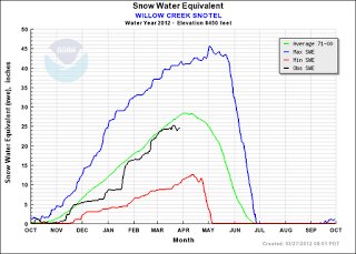
The Snow Pack observed at the Willow Creek Snotel site in the Salt River Range has shown little melting so far, even with the mild weather last week.


The river gauge on the Salt River near Etna, while indicating levels are running well above the mean, has actually dropped with the current cool down.

This evening, a deep low pressure trough off the west coast will provide an increasingly moist and mild west to southwest flow across western Wyoming into this coming weekend.
 |
||
| 500 mb Analysis Tuesday Evening 3/27/12 |
In the past couple of days the models’ forecast for the future of the offshore trough has been providing conflicting solutions. However the ECMWF(European Model) and the GFS(US Global Model) are now in close agreement that a strong trough and cold front will be impacting western Wyoming by the latter half of this coming weekend.
 |
||
| GFS and ECMWF model forecast for Saturday morning 3/31/12. |
With regard to the remainder of the work week, no big storm or cold air is expected. However, with the moist flow, the potential for rain showers in the valley and snow only in the mountains above about 7500 feet are likely. The greater chance will be from the Yellowstone Park area north and west.
 |
| Total forecast precipitation Wed-Sat 3/28-31/2012 |
Afternoon temperatures into the 50s and possibly 60s by Saturday ahead of the strong cold front, should enhance the snow melt and likely raise the levels of the Salt River and its tributaries.