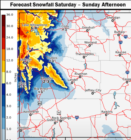
 ...Significant Snow over portions of Western Wyoming Today into
Sunday...
.A moist southwest flow along with upper level support will bring
significant snowfall across portions of western Wyoming today and
Sunday. The snow is expected to develop quickly this morning over
much of western Wyoming. The snow will gradually lift north this
evening, and be focused mainly over the far northwest tonight,
before shifting back southward early Sunday morning.
Star Valley-
Including the cities of Afton, Alpine, Star Valley Ranch,
and Thayne
821 AM MDT Sat Mar 14 2020
...WINTER WEATHER ADVISORY REMAINS IN EFFECT UNTIL 6 PM MDT THIS
EVENING...
* WHAT...Periods of snow, heavy at times. The snow could mix with or
change to rain late today.
* WHERE...Star Valley.
* WHEN...Today. The heaviest snowfall is expected between 9 AM and 2
PM.
* SNOW AMOUNTS...3 to 5 inches over northern Star Valley with 1 to 3
inches over the south.
* IMPACTS...Roads will become slick and hazards this morning, but
are expected to improve by mid to late afternoon.
* ADDITIONAL DETAILS...Please monitor the Bridger-Teton Avalanche
Center at jhavalanche.org, if your plans include travel into the
backcountry.
PRECAUTIONARY/PREPAREDNESS ACTIONS...
Slow down and use caution while traveling.
The latest road conditions for the state you are calling from can be
obtained by calling 5 1 1.
...Significant Snow over portions of Western Wyoming Today into
Sunday...

.A moist southwest flow along with upper level support will bring
significant snowfall across portions of western Wyoming today and
Sunday. The snow is expected to develop quickly this morning over
much of western Wyoming. The snow will gradually lift north this
evening, and be focused mainly over the far northwest tonight,
before shifting back southward early Sunday morning.

Star Valley-
Including the cities of Afton, Alpine, Star Valley Ranch,
and Thayne
821 AM MDT Sat Mar 14 2020

...WINTER WEATHER ADVISORY REMAINS IN EFFECT UNTIL 6 PM MDT THIS
EVENING...

* WHAT...Periods of snow, heavy at times. The snow could mix with or
  change to rain late today.

* WHERE...Star Valley.

* WHEN...Today. The heaviest snowfall is expected between 9 AM and 2
  PM.

* SNOW AMOUNTS...3 to 5 inches over northern Star Valley with 1 to 3
  inches over the south.

* IMPACTS...Roads will become slick and hazards this morning, but
  are expected to improve by mid to late afternoon.

* ADDITIONAL DETAILS...Please monitor the Bridger-Teton Avalanche
  Center at jhavalanche.org, if your plans include travel into the
  backcountry.

PRECAUTIONARY/PREPAREDNESS ACTIONS...

Slow down and use caution while traveling.

The latest road conditions for the state you are calling from can be
obtained by calling 5 1 1.