After a very dry June, July is showing encouraging signs for the Cowboy state. There were several days when much of the state, including Star Valley received beneficial showers. While drier air has returned, this should only be temporary as a new surge of Monsoon moisture is now moving northward into the Southwestern Deserts.
The following 500 mb charts, mid day on tuesday and then again on friday, show the increasing southwesterly flow which will transport moisture back into Wyoming later this week.
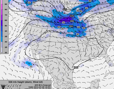 |
| 500 mb analysis Tuesday July 9, 2013
|
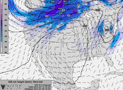 |
| 500 mb forecast Friday July12, 2013
|
The following two charts depict the precipitable water in the atmosphere both for Tuesday and the forecast for Friday,
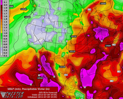 |
| Precipitable water in inches Tuesday July 9 2013
|
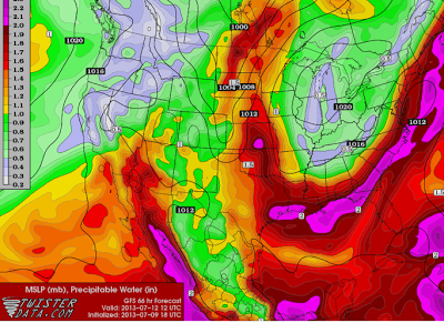 |
| Precipitable water forecast in inches for Friday July 12 2013
|
Thus after a couple warm and dry days, moisture and the increase in thunderstorms should certainly be back into Wyoming by Friday, and possibly later Thursday.
The following was a summary of the first round of Monsoon rains across the Cowboy state issued by the Riverton WFO.
UPDATED (7/9): Early start to Monsoon brings welcome rain back to Cowboy State
The monsoon season got off to an early start this year, as abundant moisture and instability were in place across Wyoming this week. This provided the needed ingredients, as weak shortwaves rotated around a high pressure center located near the Four Corners, for much needed thunderstorms to form across the area. Some of the thunderstorm activity was widespread across the forecast area for western & central Wyoming, with some storms becoming severe. These storms produced severe hail and in some cases brief heavy rain. This event is much needed, as noted in the recent
climate summary. Many locations have received much below normal precipitation since June 1 and this event will help against these deficits. So far, only Casper has risen above normal for the year (as well as through June 1). All other locations are well below normal for the year (Lander is near normal for the year, but well below normal since June 1). Below are rainfall totals from Wednesday through Monday.
 |
| Click on image to enlarge |
Rainfall Totals thru 7/8
| County |
Station Name |
Rainfall |
| Big Horn |
2 SSW Lovell |
1.78 |
| Big Horn |
Greybull ASOS |
0.25 |
| Big Horn |
Greybull |
0.09 |
| Big Horn |
Shell |
0.09 |
| Fremont |
10 WNW Dubois |
1.15 |
| Fremont |
4 ENE South Pass City |
0.50 |
| Fremont |
Dubois |
0.44 |
| Fremont |
Burris |
0.30 |
| Fremont |
Riverton ASOS |
0.27 |
| Fremont |
Riverton |
0.25 |
| Fremont |
6 SW Lander |
0.21 |
| Fremont |
16 WNW Kinnear |
0.20 |
| Fremont |
Boysen Dam |
0.18 |
| Fremont |
Lander ASOS |
0.18 |
| Fremont |
Jeffrey City |
0.14 |
| Fremont |
6 SE Lander |
0.08 |
| Fremont |
1 SW Lander |
0.07 |
| Fremont |
2 SSW Arapahoe |
0.06 |
| Fremont |
Lander |
0.04 |
| Fremont |
1 WSW Lander |
0.02 |
| Fremont |
2 NNE Lander |
0.02 |
| Fremont |
34 SE Lander |
0.02 |
| Fremont |
9 SSE Lander |
0.02 |
| Hot Springs |
11 N Thermopolis |
1.00 |
| Hot Springs |
9 NE Thermopolis |
0.33 |
| Hot Springs |
1 SW Thermopolis |
0.22 |
| Hot Springs |
Thermopolis |
0.13 |
| Johnson |
17 NNW Kaycee |
0.87 |
| Johnson |
Buffalo |
0.68 |
| Johnson |
17 E Kaycee |
0.61 |
| Johnson |
20 S Buffalo |
0.39 |
| Johnson |
Buffalo |
0.38 |
| Johnson |
7 NE Buffalo |
0.02 |
| Lincoln |
5 NNE Thayne |
0.76 |
| Lincoln |
Star Valley Ranch |
0.73 |
| Lincoln |
Afton |
0.71 |
| Lincoln |
3 SE Bedford |
0.69 |
| Lincoln |
2 SE Thayne |
0.68 |
| Lincoln |
5 SSE Smoot |
0.54 |
| Lincoln |
21 NNW Kemmerer |
0.34 |
| Lincoln |
Fossil Butte |
0.15 |
| Natrona |
Casper ASOS |
1.26 |
| Natrona |
Midwest |
0.73 |
| Natrona |
4 SW Casper |
0.66 |
| Natrona |
Casper |
0.65 |
| Natrona |
11 WSW Casper |
0.52 |
| Natrona |
11 ESE Casper |
0.50 |
| Natrona |
10 WSW Casper |
0.44 |
| Natrona |
4 WSW Casper |
0.39 |
| Natrona |
Casper |
0.37 |
| Natrona |
1 WSW Casper |
0.36 |
| Natrona |
6 S Casper |
0.35 |
| Natrona |
1 SW Casper |
0.32 |
| Natrona |
9 E Casper |
0.31 |
| Natrona |
Casper |
0.28 |
| Natrona |
2 S Casper |
0.22 |
| Natrona |
4 WSW Casper |
0.13 |
| Natrona |
Powder River School |
0.04 |
| Park |
3 NE Clark |
1.21 |
| Park |
Crandall Creek |
1.14 |
| Park |
Meeteetse |
1.09 |
| Park |
4 ENE Powell |
1.09 |
| Park |
4 SW Powell |
1.06 |
| Park |
3 NE Sunshine |
0.99 |
| Park |
Pahaska |
0.89 |
| Park |
3 N Powell |
0.69 |
| Park |
1 W Powell |
0.66 |
| Park |
4 SE Cody |
0.33 |
| Park |
2 WSW Cody |
0.33 |
| Park |
5 ESE Cody |
0.28 |
| Park |
7 SW Cody |
0.25 |
| Park |
1 ESE Cody |
0.20 |
| Park |
1 E Cody |
0.16 |
| Sublette |
13 SE Pinedale |
1.32 |
| Sublette |
Pinedale |
0.90 |
| Sublette |
Bondurant |
0.83 |
| Sublette |
14 NW Pinedale |
0.61 |
| Sublette |
Daniel Fish Hatchery |
0.36 |
| Sublette |
Big Piney ASOS |
0.36 |
| Sublette |
Boulder Rearing Station |
0.21 |
| Sweetwater |
7 SE Rock Springs |
0.43 |
| Sweetwater |
1 NW Granger |
0.32 |
| Sweetwater |
1 W Rock Springs |
0.17 |
| Sweetwater |
38 NW Superior |
0.16 |
| Sweetwater |
5 N Farson |
0.11 |
| Sweetwater |
1 S Rock Springs |
0.11 |
| Sweetwater |
1 E Rock Springs |
0.09 |
| Sweetwater |
Wamsutter |
0.08 |
| Sweetwater |
8 NNW Rock Springs |
0.02 |
| Sweetwater |
Green River |
0.02 |
| Teton |
Darwin Ranch |
1.16 |
| Teton |
Hoback Junction |
0.90 |
| Teton |
2 NE Teton Village |
0.79 |
| Teton |
Moose |
0.64 |
| Teton |
Moose |
0.60 |
| Teton |
4 SSW Jackson |
0.55 |
| Teton |
5 NW Jackson |
0.45 |
| Teton |
3 SSW Wilson |
0.42 |
| Teton |
Jackson |
0.38 |
| Teton |
12 NE Jackson |
0.32 |
| Teton |
5 WNW Moran |
0.14 |
| Teton |
1 NNW Alta |
0.11 |
| Washakie |
4 NE Ten Sleep |
0.23 |
| Washakie |
27 S Ten Sleep |
0.20 |
| Washakie |
5 NNW Ten Sleep |
0.15 |
| Washakie |
Worland ASOS |
0.12 |
| Washakie |
Ten Sleep |
0.11 |
| Washakie |
Worland |
0.07 |
| Washakie |
16 SSE Ten Sleep |
0.06 |
| Washakie |
1 W Worland |
0.05 |
| Washakie |
8 SW Worland |
0.04 |
| Yellowstone |
Lamar Ranger Station |
0.96 |
| Yellowstone |
Tower Falls Ranger Station |
0.93 |
| Yellowstone |
Lake Yellowstone ASOS |
0.83 |
| Yellowstone |
Snake River Ranger Station |
0.77 |
| Yellowstone |
Yellowstone Mammoth |
0.76 |
| Yellowstone |
Yellowstone East Entrance |
0.56 |
| Yellowstone |
Old Faithful Ranger Station |
0.35 |


