Winter Finally Heading For Wyoming!
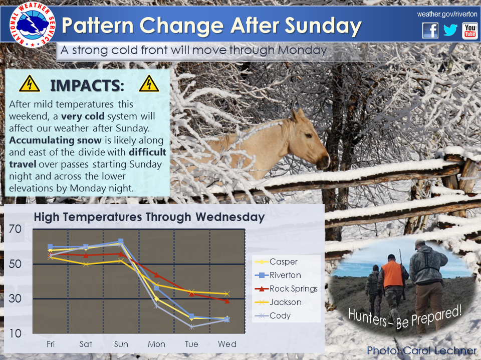
Old Man Winter arrives late this weekend and he will decide to stay a while this time. After a warm and at times, breezy weekend, expect a sharp change to cold and wintry conditions Sunday night into Monday morning. Widespread accumulating snow, well below normal temperatures, and gusty north wind will accompany an arcitc push east of the Divide on Monday, with a re-enforcing shot of cold air arriving on Tuesday into Wednesday. Temperatures will begin to rebound a bit on Thursday with another system possibly bringing rain and snow showers to the I-80 corridor. A little less impact is expected west of the Divide and across the south as the brunt of the storm remains east; only isolated snow showers and cooler temperatures are expected there.
 |
|
Click Image To Enlarge
|

Stay up to date with our current products, and what they mean as they will be updated throughout the weekend:
|
| Area Forecast Discussion | Winter Watch / Warning | Special Weather Statement | What’s a “Watch?” |
| Watch/Warning Map | Freeze Watch / Warning | Weather Story | Rain and Snow Reports |
 |
 |
| Click Loop To Enlarge
Model Depiction of Temperature at 10k feet.
Green and orange shades show more mild air, the white line is the freezing line, and anything in the blue to purple shades is cold…the icy blue to navy blue shades are very cold for this time of year, and the tan shades inside of the navy blue shades show near record breaking cold temperatures!
The loop advances in 6 hour time steps, beginning at 5am Friday morning and ending next Friday afternoon. The time stamp in the bottom right hand corner shows the valid time in “Z Time” (where 00Z = 5pm and 12Z = 5am MST) |
Click Image To Enlarge Storm Impacts
The main storm impact is expected to be a result of the very cold temperatures that will be moving in; after such a long and mild fall, this sudden and severe temperature drop will be a shock to the system. Those who plan to be outdoors for Veteran’s Day should plan for very cold temperatures, wet conditions, and gusty winds; especially Hunters.
Roads in the low elevations will be on the warm side at the beginning of the storm, this could limit snow accumulation at first on Monday but it will eventually cool enough to allow some accumulation as well as result in some icy spots, especially Monday Night and Tuesday. |
 |
| Click Image To Enlarge
Storm total snow forecast through Monday Afternoon (issued Friday Morning)
|
 |
 |
| Click Image To Enlarge 12 Hour Snow Accumulation Forecast |
Click Image To Enlarge 12 Hour Peak Wind Gusts |
 |
 |
| Click Image To Enlarge 24 Hour Snow Accumulation Forecast |
Click Image To Enlarge 24 Hour Peak Wind Gusts |
 |
|
| Click Image To Enlarge 36 Hour Snow Accumulation Forecast |
Click Image To Enlarge 36 Hour Peak Wind Gusts |
Temperature Change Sunday (11/9) Versus Wednesday (11/12)
 |
 |
| Click Image To Enlarge Sunday’s High Temperature |
Click Image To Enlarge Wednesday’s High Temperature |

|
|
|


|
|
|
|
|

|

|

|

|
|
|
|
|
|
|
|

|

|

|
|
|
|
|
|

|

|

|

|
PLEASE SEND US YOUR SNOW REPORTS (CLICK HERE)
 |
Monitor our Severe Weather Summary Page for current Warnings, Watches, and Advisories.What’s the difference? |
 |
Check the latest Weather Story graphic for an overview of the area forecast. |
 |
Check out what’s on the radar. Riverton | Pocatello | Cheyenne | Billings | Salt Lake City | Rapid City | Mosaic |
| Submit storm reports/images and keep up to date with us on Facebook! | |
 |
Submit storm reports/images and keep up to date with us on Twitter! |
 |
Other reporting methods include eSpotter, email ([email protected]), or by phone at 1-800-211-1448. |
 |
Check the latest Public Information Statement for the latest storm reports. |
| Monitor current road conditions by visiting the Wyoming Dept. of Transportation (WYDOT) or by calling 5-1-1. |
