WINTER STORM WARNING REMAINS IN EFFECT FOR STAR VALLEY UNTIL 5 AM MST THURSDAY.
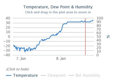
A Dramatic Warm Up has occurred in Star Valley over the weekend. The temperature graph from the Afton airport best depicts the more than 60 degrees rise that occurred from Saturday morning to Sunday morning.
 |
| Temperature at Afton Airport January 7-8 2017
|
This change of airmass is the result of a very moist storm system from the Pacific
moving inland replacing the bitter arctic airmass. The water vapor imagery from
Sunday evening vividly shows this underway as the moisture from the subtropical
Pacific surges inland toward Wyoming.
 |
| Water Vapor Imagery Sunday Evening January 8 2017 |
Western Wyoming and Star Valley will experience a direct impact from this and
additional systems this coming week, with large amounts of snowfall in the mountains
on the order of several feet and potentially 1-2 feet across parts of Star Valley.
It is such a warm air mass now that some of the precipitation may occur as rain in the
valley tonight and Monday, reducing somewhat the snowfall totals but raising the
concern for increased slickness of the roads, particularly Monday morning.
The Riverton Forecast Office has issued the following Winter Storm Warning for Star
Valley which includes much of Western Wyoming and adjacent portions of Eastern
Idaho.
URGENT - WINTER WEATHER MESSAGE NATIONAL WEATHER SERVICE RIVERTON WY 208 PM MST SUN JAN 8 2017 ...MAJOR LONG DURATION WINTER STORM TO IMPACT THE WEST THROUGH WEDNESDAY NIGHT... .SEVERAL WEATHER SYSTEMS WILL IMPACT THE WEST THROUGH WEDNESDAY NIGHT BRINGING MULTIPLE PERIODS OF MODERATE TO HEAVY SNOW AND WIND. THE MOST LIKELY TIMES FOR THE HEAVIEST SNOW AT THIS TIME APPEAR TO BE TONIGHT THROUGH MONDAY MORNING...TUESDAY MORNING AND AGAIN LATE TUESDAY EVENING THROUGH WEDNESDAY NIGHT. STAR VALLEY- INCLUDING THE CITIES OF...AFTON...ALPINE...STAR VALLEY RANCH... THAYNE 208 PM MST SUN JAN 8 2017 ...WINTER STORM WARNING REMAINS IN EFFECT UNTIL 5 AM MST THURSDAY... * TIMING...SNOW WILL INCREASE QUICKLY LATE THIS AFTERNOON WITH PERIODS OF HEAVY SNOW EXPECTED TONIGHT THROUGH AT LEAST MONDAY MORNING. ANOTHER BOUT OF HEAVY SNOW IS EXPECTED TUESDAY MORNING AND AGAIN LATE TUESDAY NIGHT THROUGH WEDNESDAY NIGHT LIGHTER SNOW BETWEEN THESE TIMES.. .THERE COULD BE A PERIOD OF RAIN ORRAIN AND SNOW MIXTURE INTO EARLY MONDAY... ESPECIALLY IN THE LOWEST SPOTS OF THE STAR VALLEY BEFORE COLDER AIR RETURNS* SNOW TOTALS...1 TO 2 FEET BY LATE WEDNESDAY NIGHT WITH THE
HEAVIER AMOUNTS TOWARDS THE NORTH END OF THE VALLEY.
* WIND AND VISIBILITY...SOUTHWEST WIND INCREASING TO 15 TO 25
MPH WITH GUSTS TO 35 MPH IN OPEN AREAS. VISIBILITIES UNDER ONE
QUARTER MILE AT TIMES IN SNOW AND BLOWING SNOW.* MAIN IMPACT...ROADS AND HIGHWAYS WILL BECOME SLICK AND SNOW
PACKED WITH SHARPLY REDUCED VISIBILITY.PRECAUTIONARY/PREPAREDNESS ACTIONS...
A WINTER STORM WARNING MEANS SIGNIFICANT AMOUNTS OF SNOW... AND
OR BLOWING SNOW ARE EXPECTED OR OCCURRING. THIS COULD MAKE TRAVEL
VERY HAZARDOUS OR IMPOSSIBLE. IF YOU MUST TRAVEL KEEP SOME FOOD...
WATER... AND AN EXTRA FLASHLIGHT IN YOUR VEHICLE IN CASE OF AN
EMERGENCY. CHECK THE LATEST ROAD CONDITIONS AT WYOROAD.INFO OR BY
DIALING 5 1 1.