Flood Watch
National Weather Service Riverton WY
150 PM MDT Mon Mar 20 2017
...Significant low elevation snowmelt through Tuesday afternoon
will cause flooding in the western valleys...
.Isolated showers are forecasted this afternoon and early evening
over the Upper Green and western valleys. Precipitation amounts
will be one to two tenths of an inch. Afternoon temperatures
today and Tuesday will be in the middle 40s to middle 50s. The
expected rain and temperatures will keep the potential for more
significant snowmelt through Tuesday afternoon.
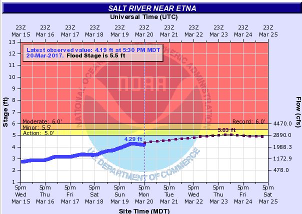
.The Salt River near Etna is running about a foot from bankfull(see image above) on
Monday afternoon. The river is expected to continue to slowly
rise on Tuesday but remaining below bankfull stage.
Jackson Hole-Star Valley-Upper Green River Basin Foothills-
Upper Green River Basin-South Lincoln County-
Including the cities of Jackson, Afton, Alpine,
Star Valley Ranch, Thayne, Pinedale, La Barge, Big Piney, Farson,
Kemmerer, and Cokeville
150 PM MDT Mon Mar 20 2017
...FLOOD WATCH NOW IN EFFECT THROUGH TUESDAY AFTERNOON...
The Flood Watch is now in effect for
* Portions of northwest Wyoming, southwest Wyoming, and west
central Wyoming, including the following areas, in northwest
Wyoming, Jackson Hole. In southwest Wyoming, South Lincoln
County. In west central Wyoming, Star Valley, Upper Green
River Basin, and Upper Green River Basin Foothills.
* Through Tuesday afternoon
* The warmer valley temperatures and forecasted rain on a ripe and
melting snowpack will cause significant low elevation snowmelt
runoff.
* Flooding of smaller streams, culverts, and other low lying areas
will remain a distinct possibility through Tuesday afternoon.
PRECAUTIONARY/PREPAREDNESS ACTIONS...
A Flood Watch means there is a potential for flooding based on
current forecasts.
People living in flood prone areas across the western valleys
and across the Upper Green Basin should begin preparing for
rising water across low lying areas such as drainage ditches,
bridges, and basements. You should monitor later forecasts and be
alert for possible Flood Warnings.

