Snow Totals Christmas Day
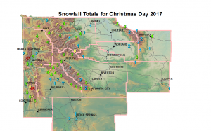
Public Information Statement
National Weather Service Riverton WY
0212 PM MST Tue Dec 26 2017

...Snowfall Totals for Christmas Day through early this morning...

A weak upper level disturbance within the weak, west northwest flow
aloft produced some snow accumulations on Christmas day, last night
and early this morning on both sides of the Continental Divide. The
following are snow totals from this latest snow event.

Location                              Snowfall

Big Horn County...
 Bald Mountain Snotel...              3 inches.
 Bone Springs Divide Snotel...        3 inches.
 Shell Creek Snotel...                2 inches.
 9 ENE Greybull...                  1.6 inches.

Fremont County...
 Brooks Lake...                       7 inches.
 St. Lawrence Alt Snotel...           5 inches.
 Little Warm Snotel...                3 inches.
 Burroughs Creek Snotel...            3 inches.
 Castle Creek Snotel...               3 inches.
 South Pass Snotel...                 3 inches.
 Townsend Creek Snotel...             3 inches.
 Cold Springs Snotel...               2 inches.
 Hobbs Park Snotel...                 2 inches.
 Deer Park Snotel...                  2 inches.

Hot Springs County...
 Owl Creek Snotel...                  1 inch.

Johnson County...
 Buffalo...                         3.5 inches.
 Soldier Park Snotel...               2 inches.
 Little Goose Snotel...               1 inch.
 Hansen Sawmill Snotel...             1 inch.
 Cloud Peak Reservoir Snotel...       1 inch.
 Bear Trap Meadow Snotel...           1 inch.
 17 NNW Kaycee...                   0.5 inches.

Lincoln County...
 Commissary Ridge...                 15 inches.
 Spring Creek Divide Snotel...       10 inches.
 Willow Creek Snotel...               9 inches.
 Cottonwood Creek Snotel...           8 inches.
 Box Y Ranch...                       8 inches.
 5 SSE Smoot...                       8 inches.
 Indian Creek Snotel...               7 inches.
 Blind Bull Summit Snotel...          6 inches.
 Blind Bull Summit...                 6 inches.
 4 ENE Thayne...                    5.5 inches.
 Kelley Ranger Station Snotel...      5 inches.
 Salt River Summit Snotel...          5 inches.
 Hams Fork Snotel...                  5 inches.
 5 NNE Thayne...                    4.8 inches.
 2 SE Thayne...                     4.8 inches.
 Star Valley Ranch...                 4 inches.
 3 SE Bedford...                    3.5 inches.
 Afton...                           3.2 inches.

Natrona County...
 Reno Hill Snotel...                  1 inch.
 Grave Springs Snotel...              1 inch.
 Casper Mountain Snotel...            1 inch.
 4 WSW Casper...                    0.2 inches.
 Casper Airport...                  0.1 inches.
 Casper...                          0.1 inches.
 1 S Casper...                      0.1 inches.

Park County...
 Kirwin Snotel...                     6 inches.
 Evening Star Snotel...               5 inches.
 Beartooth Lake Snotel...             5 inches.
 Blackwater Snotel...                 4 inches.
 Wolverine Snotel...                  4 inches.
 2 WSW Cody...                        4 inches.
 Marquette Snotel...                  3 inches.
 Cody...                              3 inches.
 4 ENE Powell...                    1.2 inches.
 4 SE Cody...                       1.2 inches.
 Timber Creek Snotel...               1 inch.
 26 SW Cody...                        1 inch.
 Powell...                          0.9 inches.
 Pahaska...                         0.2 inches.

Sublette County...
 Triple Peak Snotel...               10 inches.
 Snider Basin Snotel...               8 inches.
 Loomis Park Snotel...                7 inches.
 Big Sandy Opening Snotel...          5 inches.
 New Fork Lake Snotel...              4 inches.
 Kendall Ranger Station Snotel...     4 inches.
 Pocket Creek Snotel...               4 inches.
 East Rim Divide Snotel...            4 inches.
 14 NW Pinedale...                  3.7 inches.
 Gunsite Pass Snotel...               3 inches.
 Larsen Creek Snotel...               3 inches.
 Elkhart Park G.S. Snotel...          3 inches.
 Pinedale...                        2.2 inches.
 Daniel Fish Hatchery...              1 inch.
 13 NE Big Piney...                   1 inch.

Sweetwater County...
 Rock Springs...                      2 inches.
 Rock Springs...                    1.6 inches.
 Green River...                     1.5 inches.
 Green River...                     1.3 inches.
 4 NNW Rock Springs...              1.2 inches.
 Green River...                     0.8 inches.
 7 SE Rock Springs...               0.2 inches.

Teton County...
 Jackson Hole - Raymer...          15.5 inches.
 Jackson Hole - Rendezvous Bowl...   13 inches.
 Jackson Hole - Mid Mountain...    10.5 inches.
 Grand Targhee Snotel...              9 inches.
 Togwotee Pass Snotel...              8 inches.
 Grassy Lake Snotel...                7 inches.
 Granite Creek Snotel...              7 inches.
 Togwotee Mountain Lodge...           7 inches.
 Jackson Hole - Base...             6.5 inches.
 Base Camp Snotel...                  6 inches.
 Grand Targhee - Chief Joseph...      6 inches.
 Snake River Stn Snotel...            6 inches.
 Phillips Bench Snotel...             5 inches.
 2 NE Teton Village...              4.7 inches.
 3 NNE Wilson...                    4.6 inches.
 5 NW Jackson...                    4.1 inches.
 Moose...                             4 inches.
 Snow King...                         4 inches.
 Gros Ventre Summit Snotel...         3 inches.
 3 SSW Wilson...                      3 inches.
 1 NNW Alta...                        2 inches.
 Jackson Dam...                     1.5 inches.
 12 NE Jackson...                   1.5 inches.
 2 SW Wilson...                     0.5 inches.

Washakie County...
 Middle Powder Snotel...              3 inches.
 Powder River Pass Snotel...          2 inches.
 Ten Sleep...                       1.9 inches.
 5 NNW Ten Sleep...                 1.4 inches.
 Winchester...                      0.5 inches.

Yellowstone National Park...
 Parker Peak Snotel...                7 inches.
 Sylvan Road Snotel...                6 inches.
 Lewis Lake Divide Snotel...          6 inches.
 Canyon Snotel...                     4 inches.
 Sylvan Lake Snotel...                4 inches.
 Two Ocean Plateau Snotel...          4 inches.
 Thumb Divide Snotel...               4 inches.
 Snake River Ranger Station...        3 inches.
 Lamar Ranger Station...            1.5 inches.