..More significant areas of accumulating snow are expected for
along and west of the Continental Divide from Thursday Afternoon
through the day Friday...
.Periods of very light snow or flurries will continue
periodically the rest of today through Thursday morning. Then the
next Pacific weather disturbance will move into the region giving
a new period of significant accumulating snowfall from later
Thursday afternoon through the day Friday. Moderate to locally
heavy snowfall accumulations are expected with this system
particularly from later Thursday afternoon through Thursday
night.Jackson Hole-Star Valley-
Including the cities of Jackson, Afton, Alpine,
Star Valley Ranch, and Thayne
318 PM MST Wed Jan 10 2018
...WINTER WEATHER ADVISORY REMAINS IN EFFECT FROM 11 AM THURSDAY
TO 5 PM MST FRIDAY...
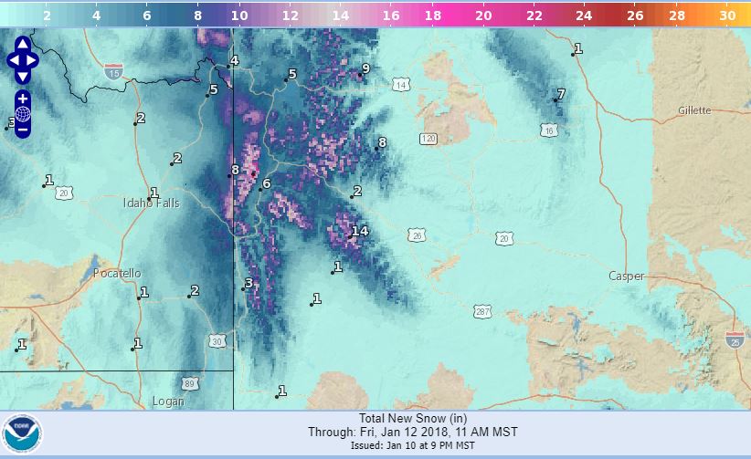
* WHAT...Snow expected. Plan on difficult travel conditions,
including during the evening commute on Thursday. Total snow
accumulations of 3 to 6 inches, with localized amounts up to 8
inches, are expected.
* WHERE...Jackson Hole and Star Valley.
* WHEN...11 AM Thursday to 5 PM Friday.
* ADDITIONAL DETAILS...Be prepared for reduced visibilities at
times.
PRECAUTIONARY/PREPAREDNESS ACTIONS...
A Winter Weather Advisory for snow means periods of snow will
cause primarily travel difficulties. Be prepared for snow covered
roads and limited visibilities, and use caution while driving.
The latest road conditions for the state you are calling from can
be obtained by calling 5 1 1.