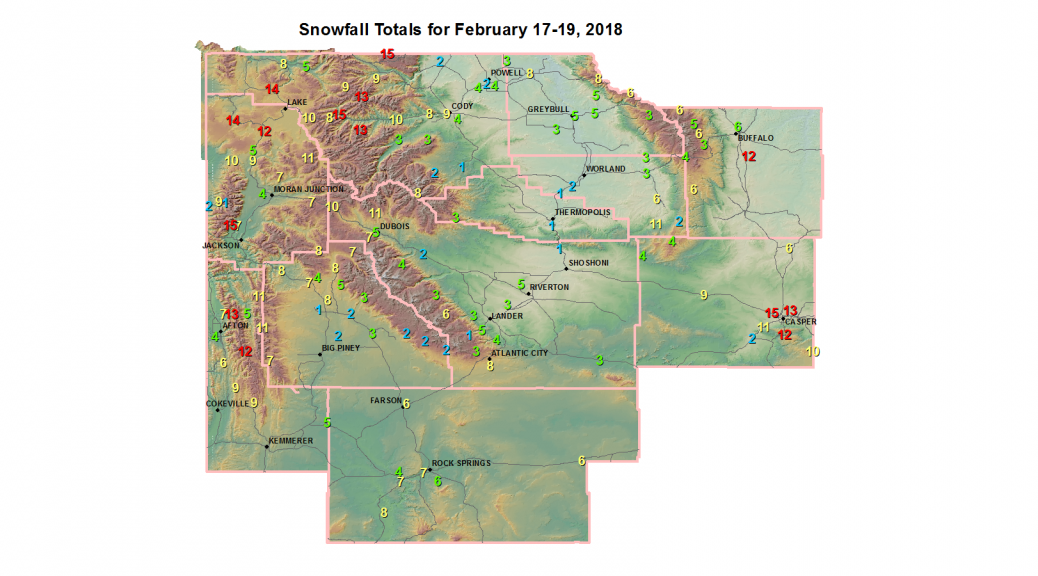
 SnowMap February 17-19 2018
National Weather Service Riverton WY
1237 PM MST Tue Feb 20 2018


Final storm totals for this weekend`s storm are in.  Totals are
from Saturday through Monday, collected at noon today. A Canadian
winter storm and Arctic front moved into the northwest Saturday and
finally exited southeast Monday.  This system brought significant
snow and bitter cold temperatures, which are still impacting the
area.
Thanks to all who have reported their snow totals.

Note: SnoTELS (Snow Telemetry) are remote sensing sites in high
mountain watersheds. Snowfall data from SNOTELS are estimated based
on snow water equivalent.

Location                              Snowfall

Big Horn County...
 2 SSW Lovell...                    8.5 inches.
 1 W Lovell...                        8 inches.
 Bald Mountain Snotel...              8 inches.
 Lovell...                            7 inches.
 Bone Springs Divide Snotel...        6 inches.
 Greybull...                        5.2 inches.
 9 NNW Shell...                     5.1 inches.
 9 ENE Greybull...                  4.8 inches.
 Shell Creek Snotel...                3 inches.
 Deaver...                            3 inches.
 7 W Basin...                       2.6 inches.

Fremont County...
 Burroughs Creek Snotel...           11 inches.
 Brooks Lake...                    10.1 inches.
 Atlantic City...                   7.5 inches.
 Little Warm Snotel...                7 inches.
 Castle Creek Snotel...               7 inches.
 Hobbs Park Snotel...                 6 inches.
 2 W Riverton...                    5.3 inches.
 4 W Riverton...                      5 inches.
 Riverton Airport...                  5 inches.
 6 SW Lander...                     4.7 inches.
 Dubois...                          4.5 inches.
 Deer Park Snotel...                  4 inches.
 2 W Riverton...                      4 inches.
 Riverton...                          4 inches.
 Cold Springs Snotel...               4 inches.
 Lander Airport...                  3.9 inches.
 9 S Lander...                      3.5 inches.
 St. Lawrence Alt Snotel...           3 inches.
 South Pass Snotel...                 3 inches.
 Jeffrey City...                      3 inches.
 7 SE Lander...                       3 inches.
 1 N Lander...                        3 inches.
 Hudson...                            3 inches.
 Lander...                        2.5-3 inches.
 7 WNW Lander...                    2.9 inches.
 Burris...                            2 inches.
 Boysen Dam...                        1 inch.
 Townsend Creek Snotel...             1 inch.

Hot Springs County...
 Owl Creek Snotel...                  3 inches.
 2 NNE Lucerne...                   1.7 inches.
 Thermopolis...                     1.3 inches.
 9 NE Thermopolis...                  1 inch.

Johnson County...
 13 SSE Buffalo...                   12 inches.
 Soldier Park Snotel...               6 inches.
 Bear Trap Meadow Snotel...           6 inches.
 Little Goose Snotel...               6 inches.
 Buffalo...                         6.7 inches.
 Cloud Peak Reservoir Snotel...       5 inches.
 Hansen Sawmill Snotel...             3 inches.

Lincoln County...
 Willow Creek Snotel...              13 inches.
 Commissary Ridge...               12.1 inches.
 Blind Bull Summit...              11.1 inches.
 Indian Creek Snotel...              11 inches.
 Spring Creek Divide Snotel...       11 inches.
 Hams Fork Snotel...                  9 inches.
 Kelley Ranger Station Snotel...      9 inches.
 5 NNE Thayne...                      8 inches.
 5 SSE Smoot...                       8 inches.
 Cottonwood Creek Snotel...           7 inches.
 3 SE Bedford...                      7 inches.
 Salt River Summit Snotel...          6 inches.
 Box Y Ranch...                     5.1 inches.
 3 S Fontenelle Dam...                5 inches.
 Star Valley Ranch...               4.7 inches.
 Afton...                           4.4 inches.
 Blind Bull Summit Snotel...          4 inches.
 Fairview...                          4 inches.


Natrona County...
 2 E Evansville...                   15 inches.
 Casper Airport...                 14.7 inches.
 Casper...                        10-14 inches.
 Evansville...                       13 inches.
 1 SW Casper...                    12.5 inches.
 Mills...                            12 inches.
 Casper Mountain Snotel...           12 inches.
 4 SW Casper...                      12 inches.
 10 WSW Casper...                   11 inches.
 4 WSW Casper...                   10.9 inches.
 5 SSW Casper...                   10.5 inches.
 Reno Hill Snotel...                 10 inches.
 Powder River...                    8.5 inches.
 1 S Casper...                      7.5 inches.
 1 SE Casper...                     7.5 inches.
 Midwest...                         5-6 inches.
 Powder River...                    4.5 inches.
 Grave Springs Snotel...              4 inches.
 12 NE Lysite...                    3.5 inches.
 18 SW Casper...                      2 inches.

Park County...
 Beartooth Lake Snotel...            15 inches.
 Pahaska...                          15 inches.
 Evening Star Snotel...              13 inches.
 Blackwater Snotel...                13 inches.
 7 NW Cody...                      11.1 inches.
 Wapiti...                           10 inches.
 Wolverine Snotel...                  9 inches.
 2 WSW Cody...                      8.5 inches.
 8 W Cody...                          8 inches.
 Kirwin Snotel...                     8 inches.
 Cody...                          2-4.5 inches.
 4 SW Powell...                       4 inches.
 4 ENE Powell...                    3.8 inches.
 4 SE Cody...                       3.8 inches.
 Marquette Snotel...                  3 inches.
 26 SW Cody...                        3 inches.
 Powell...                            2 inches.
 4 ENE Powell...                      2 inches.
 3 NE Clark...                        2 inches.
 Timber Creek Snotel...               2 inches.
 3 NE Sunshine...                   1.4 inches.

Sublette County...
 Triple Peak Snotel...               11 inches.
 Bondurant...                       8.4 inches.
 14 NW Pinedale...                  8.2 inches.
 Kendall Ranger Station Snotel...     8 inches.
 Gunsite Pass Snotel...               7 inches.
 East Rim Divide Snotel...            7 inches.
 Snider Basin Snotel...               7 inches.
 New Fork Lake Snotel...              5 inches.
 Loomis Park Snotel...                4 inches.
 Elkhart Park G.S. Snotel...          3 inches.
 Boulder Rearing Station...           3 inches.
 Larsen Creek Snotel...               2 inches.
 Pocket Creek Snotel...               2 inches.
 Big Sandy Opening Snotel...          2 inches.
 13 NE Big Piney...                 1.5 inches.
 Pinedale...                        1.5 inches.
 Daniel Fish Hatchery...            1.4 inches.

Sweetwater County...
 Rock Springs...                    8.4 inches.
 Buckboard Marina...                  8 inches.
 Rock Springs...                    7.9 inches.
 4 NNW Rock Springs...              7.7 inches.
 4 NW Rock Springs...                 7 inches.
 Green River...                       7 inches.
 Wamsutter...                         6 inches.
 2 NNE Farson...                      6 inches.
 Green River...                     5.5 inches.
 7 SE Rock Springs...               5.5 inches.
 Wamsutter...                         5 inches.
 Green River...                   4-4.5 inches.

Teton County...
 Jackson Hole - Raymer...            15 inches.
 Jackson Hole - Rendezvous Bowl... 11.1 inches.
 Phillips Bench Snotel...            11 inches.
 Granite Creek Snotel...             11 inches.
 Grassy Lake Snotel...               10 inches.
 Togwotee Pass Snotel...             10 inches.
 Snow King...                       9.5 inches.
 Grand Targhee - Chief Joseph...    9.1 inches.
 Snake River Stn Snotel...            9 inches.
 Gros Ventre Summit Snotel...         8 inches.
 Jackson Hole - Mid Mountain...     7.1 inches.
 Togwotee Mountain Lodge...         7.1 inches.
 Base Camp Snotel...                  7 inches.
 1 ENE Teton Village...             6.5 inches.
 Jackson Hole - Base...             6.1 inches.
 Jackson...                         5.5 inches.
 Jackson Dam...                     3.8 inches.
 Alta...                              2 inches.
 1 NNW Alta...                        2 inches.
 Grand Targhee Snotel...              1 inch.

Washakie County...
 27 S Ten Sleep...                 11.3 inches.
 16 SSE Ten Sleep...                  6 inches.
 Powder River Pass Snotel...          4 inches.
 Ten Sleep...                       3.2 inches.
 5 NNW Ten Sleep...                 2.9 inches.
 Middle Powder Snotel...              2 inches.
 4 N Ten Sleep...                   1.8 inches.
 8 SW Worland...                    1.5 inches.
 Winchester...                        1 inch.

Yellowstone National Park...
 Canyon Snotel...                    14 inches.
 Old Faithful Ranger Station...      14 inches.
 Thumb Divide Snotel...              12 inches.
 Two Ocean Plateau Snotel...         11 inches.
 Snake River Ranger Station...     10.8 inches.
 Sylvan Lake Snotel...               10 inches.
 Parker Peak Snotel...                9 inches.
 Sylvan Road Snotel...                8 inches.
 Tower Falls Ranger Station...        8 inches.
 Lamar Ranger Station...              5 inches.
 Lewis Lake Divide Snotel...          5 inches.