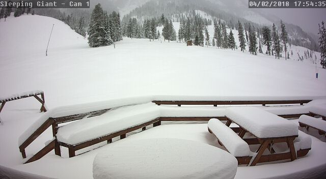
Cold and Snow Summary for Western Wyoming-April 3 2018
Winter-like Cold was experienced much of Wyoming and surrounding areas Tuesday morning April 3 2018. Temperatures dropped to 10 below and lower in the coldest spots in Wyoming, Utah and Idaho. The coldest was -22 at Peter Sinks in the high mountain valley west of Bear Lake.

Star Valley experienced generally low teens to single digits. The coldest reported in the Valley was 6 above at the Afton Airport and in Smoot.
Snow and strong winds swept across the area Monday afternoon and evening.
Winds gust around 40mph ushered in the cold air Monday afternoon across Star Valley. Thayne reported 46 mph and 44 mph at Star Valley Ranch.
Following is a storm summary from the Riverton Forecast Office
April 2, 2018 – A potent early spring storm system ushered in strong wind across much of western and central Wyoming on Monday. Heavy snow developed across much of northern Wyoming behind a cold front. 6″ to 9″ of snow fell from Cody to Meeteetse closing State Highway 120 Monday evening. Snow and strong wind also closed Interstates 25 and 90 across Johnson County along with U.S. Highway 16 over Powder River Pass. Winter Storm Warnings remained in effect until 6 am Tuesday for eastern Johnson County.
About a foot fell near Pahaska just east of Yellowstone NP.
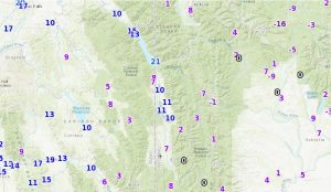
*** Snowfall Reports from Sunday evening, April 1st until 8 am Tuesday, April 3, 2018 ***

Location                             Snowfall

Big Horn County...
 Bald Mountain Snotel...              8 inches.
 Bone Springs Divide Snotel...        7 inches.
 2 SSW Lovell...                      6 inches.
 Byron...                             5 inches.
 Lovell...                            4 inches.
 Shell Creek Snotel...                3 inches.
 1 W Lovell...                        2 inches.
 9 ENE Greybull...                  1.1 inches.
 Powell Field Station...              1 inch.
 Deaver...                            1 inch.
 7 W Basin...                         1 inch.
 Greybull...                        0.9 inches.

Fremont County...
 Little Warm Snotel...                7 inches.
 Brooks Lake...                       7 inches.
 Burroughs Creek Snotel...            5 inches.
 Hobbs Park Snotel...                 5 inches.
 Castle Creek Snotel...               3 inches.
 Cold Springs Snotel...               2 inches.
 Deer Park Snotel...                  1 inch.
 St. Lawrence Alt Snotel...           1 inch.
 Lander Airport...                  0.1 inches.
 9 SSE Lander...                    0.1 inches.

Hot Springs County...
 Wind River Canyon...               3.5 inches.
 9 NE Thermopolis...                1.4 inches.
 Lucerne...                         0.6 inches.

Johnson County...
 Little Goose Snotel...              10 inches.
 Hansen Sawmill Snotel...            10 inches.
 Cloud Peak Reservoir Snotel...       9 inches.
 Soldier Park Snotel...               7 inches.
 Bear Trap Meadow Snotel...           6 inches.
 17 NNW Kaycee...                   4.5 inches.
 4 SSW Buffalo...                     4 inches.
 13 SSE Buffalo...                    3 inches.
 Buffalo...                         2.5 inches.

Lincoln County...
 Blind Bull Summit...                 8 inches.
 Blind Bull Summit Snotel...          7 inches.
 Willow Creek Snotel...               6 inches.
 5 SSE Smoot...                       4 inches.
 Box Y Ranch...                       3 inches.
 Cottonwood Creek Snotel...           3 inches.
 Commissary Ridge...                  2 inches.
 Spring Creek Divide Snotel...        2 inches.
 5 NNE Thayne...                    1.5 inches.
 Fossil Butte...                      1 inch.
 2 SE Thayne...                     0.8 inches.
 Afton...                           0.6 inches.

Natrona County...
 1 S Casper...                      3.8 inches.
 Grave Springs Snotel...              3 inches.
 Casper Mountain Snotel...            3 inches.
 5 SSW Casper...                      3 inches.
 4 WSW Casper...                    2.8 inches.
 Edgerton...                        2.5 inches.
 10 WSW Casper...                     2 inches.
 Midwest...                           2 inches.
 Casper...                            2 inches.
 Casper Airport...                  1.3 inches.
 11 WSW Casper...                     1 inch.
 Powder River...                      1 inch.

Park County...
 Beartooth Lake Snotel...            16 inches.
 Blackwater Snotel...                14 inches.
 Wolverine Snotel...                 14 inches.
 Pahaska...                        13.6 inches.
 Evening Star Snotel...              12 inches.
 5 WSW Meeteetse...                  10 inches.
 Marquette Snotel...                 10 inches.
 Kirwin Snotel...                     9 inches.
 2 WSW Cody...                      8.5 inches.
 Cody...                       1.6 to 8 inches.
 3 NE Clark...                      7.5 inches.
 3 NE Sunshine...                     7 inches.
 4 SE Cody...                       5.7 inches.
 4 SW Powell...                     4.2 inches.
 Wapiti...                            4 inches.
 Powell...                          3.5 inches.
 4 ENE Powell...                    2.2 inches.
 Timber Creek Snotel...               1 inch.

Sublette County...
 Triple Peak Snotel...                7 inches.
 Loomis Park Snotel...                7 inches.
 Gunsite Pass Snotel...               7 inches.
 Kendall Ranger Station Snotel...     4 inches.
 East Rim Divide Snotel...            3 inches.
 Elkhart Park G.S. Snotel...          1 inch.
 Snider Basin Snotel...               1 inch.
 14 NW Pinedale...                    1 inch.
 Pinedale...                 0.3 to 0.5 inches.

Teton County...
 Jackson Hole - Raymer...            12 inches.
 Jackson Hole - Mid Mountain...      10 inches.
 Granite Creek Snotel...              9 inches.
 Jackson Hole - Rendezvous Bowl...    9 inches.
 Togwotee Pass Snotel...              8 inches.
 Phillips Bench Snotel...             7 inches.
 Gros Ventre Summit Snotel...         7 inches.
 Darwin Ranch...                    6.1 inches.
 Togwotee Mountain Lodge...           6 inches.
 Base Camp Snotel...                  6 inches.
 Snow King...                         4 inches.
 Grand Targhee - Chief Joseph...      4 inches.
 3 SSW Wilson...                      3 inches.
 Grassy Lake Snotel...                3 inches.
 Snake River Stn Snotel...            2 inches.
 Moose...                           1.2 inches.
 2 NE Teton Village...                1 inch.
 Jackson Hole - Base...               1 inch.
 Grand Targhee Snotel...              1 inch.
 12 NE Jackson...                   0.5 inches.
 Jackson...                         0.5 inches.
 Jackson Dam...                     0.3 inches.

Washakie County...
 Middle Powder Snotel...              7 inches.
 27 S Ten Sleep...                  3.5 inches.
 Powder River Pass Snotel...          3 inches.
 16 SSE Ten Sleep...                  2 inches.
 5 NNW Ten Sleep...                   1 inch.
 8 SW Worland...                    0.5 inches.

Yellowstone National Park...
 Sylvan Lake Snotel...               13 inches.
 Sylvan Road Snotel...               13 inches.
 Parker Peak Snotel...               11 inches.
 Thumb Divide Snotel...              11 inches.
 Two Ocean Plateau Snotel...         11 inches.
 Canyon Snotel...                     5 inches.
 Lewis Lake Divide Snotel...          3 inches.
***** 24 Hour Peak Wind Reports Ending 11 PM on April 2, 2018 *****

Location                     Speed     Time/Date       Elevation (ft.)

...Wyoming...

...Big Horn County...
Cowley Airport               52 MPH    0315 PM 04/02   4090
Greybull Airport             49 MPH    0606 PM 04/02   3935

...Fremont County...
Red Canyon                   63 MPH    1110 AM 04/02   6768
Beaver Rim                   56 MPH    0146 PM 04/02   6784
8 W South Pass City          54 MPH    0250 PM 04/02   8120
Lander Airport               54 MPH    1217 PM 04/02   5586
Jeffrey City                 53 MPH    0228 PM 04/02   6374
Dubois Airport               53 MPH    0355 PM 04/02   7297
10 W Fort Washakie           53 MPH    0501 AM 04/02   9235
10 N Dubois                  52 MPH    1257 PM 04/02   8085
Riverton Airport             48 MPH    0526 PM 04/02   5525
3 S Togwotee Pass            47 MPH    0100 PM 04/02   10430
3 NNW Hudson                 47 MPH    1146 AM 04/02   5555
2 W South Pass City          45 MPH    0146 PM 04/02   8185

...Hot Springs County...
Thermopolis                  46 MPH    1130 PM 04/01   4426

...Johnson County...
25 ESE Buffalo               54 MPH    1015 PM 04/02   4657
7 SW Barnum                  53 MPH    1246 AM 04/02   6440
Buffalo Airport              48 MPH    1023 PM 04/02   4970
5 ESE Story                  47 MPH    1016 PM 04/02   4673

...Lincoln County...
13 W Kemmerer                47 MPH    0545 PM 04/02   6718
Thayne                       45 MPH    0418 PM 04/02   5928
1 S Bedford                  45 MPH    0617 PM 04/02   6279

...Natrona County...
16 S Hiland                  71 MPH    0410 PM 04/02   6380
Casper Airport               54 MPH    1046 AM 04/02   5320
7 W Alcova                   54 MPH    0345 PM 04/02   6342
8 S Casper                   52 MPH    0252 PM 04/02   7740
2 SE Hiland                  50 MPH    1035 PM 04/02   6134
Casper Outer Drive           49 MPH    1121 AM 04/02   5463

...Park County...
Hoyt Peak                    70 MPH    0815 AM 04/02   9800
8 N Meeteetse                55 MPH    0436 PM 04/02   5926
8 S Clark                    51 MPH    0600 PM 04/02   4710
Powell Airport               51 MPH    0255 PM 04/02   5050
2 N Frannie                  50 MPH    0339 PM 04/02   4275
1 W Clark                    46 MPH    0342 PM 04/02   4270
Powell                       45 MPH    0510 PM 04/02   4386
3 E Pahaska                  45 MPH    0557 PM 04/02   7500

...Sublette County...
Big Piney Airport            55 MPH    1107 AM 04/02   6974
21 W Big Piney               49 MPH    0809 PM 04/02   8200
Pinedale Airport             47 MPH    0235 PM 04/02   7085

...Sweetwater County...
I 80 - Mile Marker 142       63 MPH    0440 PM 04/02   7162
15 SE Rock Springs           56 MPH    0844 PM 04/02   7550
Rock Springs Airport         55 MPH    0222 PM 04/02   6760
Farson                       55 MPH    0135 PM 04/02   6594
3 ENE Granger                54 MPH    1145 AM 04/02   6254
I 80 - Mile Marker 157       54 MPH    0335 PM 04/02   6965
I 80 - Mile Marker 184       52 MPH    0516 PM 04/02   7112
20 ENE Opal                  52 MPH    0206 PM 04/02   6556
23 W Wamsutter               52 MPH    0515 PM 04/02   6804
5 E Rock Springs             50 MPH    0315 PM 04/02   6369
I 80 - Mile Marker 124       47 MPH    0431 PM 04/02   6475
7 WSW Rock Springs           46 MPH    0335 PM 04/02   6238

...Teton County...
Summit - Jackson Resort      62 MPH    1045 AM 04/02   10318
5 ENE Alta - Freds Mtn       61 MPH    0215 PM 04/02   9840
4 N Moose                    48 MPH    0458 PM 04/02   6730
Jackson Hole Airport         45 MPH    0459 PM 04/02   6445

...Washakie County...
15 SSW Big Trails            50 MPH    1140 PM 04/01   6554