Flood Watch Star Valley Over the Weekend
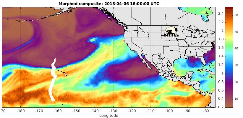
An unusually late season Atmospheric River pattern has set up across the Eastern Pacific Ocean. The following three satellite images provide a clear depiction of the situation.
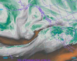
The water vapor image show the clear feed of moisture originating southwest of Hawaii and currently impacting the Pacific coast.
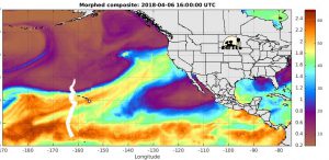
This image of precipitable water shows amounts in excess of 1.5 inches impacting the California coast. This is an unusually high amount for April onto the West Coast.
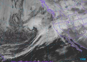
The final image is the visible satellite showing the intensifying storm west of Oregon aiding the transport of moisture toward Wyoming.
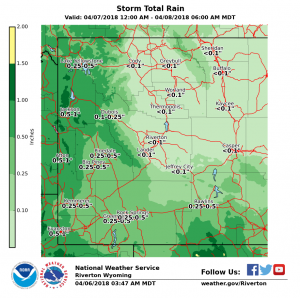
Already around half an inch of rain fell Thursday night with at least that much or more on Saturday coupled with a much higher snow level which will enhance the snow melt and runoff.
Therefore the Riverton Forecast Office has posted a Flood Watch for later Saturday and Sunday.
Flood Watch
National Weather Service Riverton WY
900 AM MDT Fri Apr 6 2018

...Minor flooding of low lying areas over Star
Valley and Jackson Hole Saturday afternoon through Sunday
afternoon...

.Afternoon valley temperatures are expected to warm into the
mid 40s to around 50 through Saturday across far western Wyoming.
Another half inch to three quarters of inch of rain is expected
for Saturday. Snow levels are expected to rise around 9000 feet
on Saturday.


Jackson Hole-Star Valley-
Including the cities of Jackson, Afton, Alpine,
Star Valley Ranch, and Thayne
900 AM MDT Fri Apr 6 2018

...FLOOD WATCH IN EFFECT FROM SATURDAY AFTERNOON THROUGH SUNDAY
AFTERNOON...

The National Weather Service in Riverton has issued a

* Flood Watch for portions of northwest Wyoming and west central
  Wyoming, including the following areas, in northwest Wyoming,
  Jackson Hole. In west central Wyoming, Star Valley.

* From Saturday afternoon through Sunday afternoon

* Afternoon valley temperatures are expected to warm into the mid
  40s to around 50 through Saturday across far western Wyoming.
  Another half inch to three quarters of inch of rain is expected
  for Saturday. Snow levels are expected to rise around 9000 feet
  on Saturday. Expect noticeable increases in snowmelt runoff
  below 8000 feet Saturday morning through Saturday evening.

* A combination of rainfall and snowmelt runoff over Star Valley
  and Jackson Hole will cause noticeable sharp rises along small
  creeks and streams Saturday night through early Sunday. Minor
  flooding is possible along low lying areas Saturday afternoon
  through Sunday afternoon.

PRECAUTIONARY/PREPAREDNESS ACTIONS...

A Flood Watch means there is a potential for flooding based on
current forecasts.

Residents living along small creeks and streams in Jackson Hole
and in Star Valley should be vigilant for possible significant
rises in water levels Saturday afternoon through Sunday afternoon.
Road crossings along low lying areas may become hazardous due to
rising waters.

You should monitor later forecasts and be alert for possible
Flood Warnings. Those living in areas prone to flooding should be
prepared to take action should flooding develop.