Public Information Statement
National Weather Service Riverton WY
721 PM MST Sat Dec 01 2018
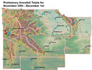
...Preliminary Storm Information...
The following are snowfall reports received today with snowfall
totals since early Thursday afternoon. Most of these reports were
received between 7 am and 9 am Saturday morning.
***** Snowfall Reports *****
Location Snowfall
Big Horn County...
Shell Creek Snotel... 4 inches.
Bald Mountain Snotel... 3 inches.
9 ENE Greybull... 2.3 inches.
Bone Springs Divide Snotel... 2 inches.
2 SSW Lovell... 2 inches.
Greybull... 1.9 inches.
9 NNW Shell... 1.9 inches.
Fremont County...
Brooks Lake... 6 inches.
Burroughs Creek Snotel... 5 inches.
Castle Creek Snotel... 4 inches.
Deer Park Snotel... 3 inches.
Little Warm Snotel... 3 inches.
Hobbs Park Snotel... 2 inches.
Dubois... 2 inches.
Atlantic City... 1.7 inches.
Cold Springs Snotel... 1 inch.
Hot Springs County...
Owl Creek Snotel... 3 inches.
Thermopolis... 1.1 inches.
9 NE Thermopolis... 0.7 inches.
Lucerne... 0.3 inches.
Johnson County...
Soldier Park Snotel... 3 inches.
Bear Trap Meadow Snotel... 2 inches.
Cloud Peak Reservoir Snotel... 2 inches.
Hansen Sawmill Snotel... 2 inches.
17 E Kaycee... 2 inches.
Lincoln County...
Willow Creek Snotel... 11 inches.
Cottonwood Creek Snotel... 9 inches.
Commissary Ridge... 8 inches.
Indian Creek Snotel... 8 inches.
Blind Bull Summit... 8 inches.
Star Valley Ranch... 8 inches.
5 SSE Smoot... 7 inches.
3 SE Bedford... 7 inches.
Kelley Ranger Station Snotel... 7 inches.
Box Y Ranch... 7 inches.
Blind Bull Summit Snotel... 6 inches.
Hams Fork Snotel... 6 inches.
Salt River Summit Snotel... 6 inches.
Spring Creek Divide Snotel... 5 inches.
2 SE Thayne... 4.7 inches.
Afton... 4.1 inches.
Fossil Butte... 4 inches.
Natrona County...
Grave Springs Snotel... 2 inches.
Park County...
Blackwater Snotel... 7 inches.
Kirwin Snotel... 6 inches.
Pahaska... 4 inches.
Beartooth Lake Snotel... 4 inches.
Evening Star Snotel... 4 inches.
Marquette Snotel... 3 inches.
4 SW Powell... 2 inches.
Younts Peak Snotel... 2 inches.
2 WSW Cody... 2 inches.
3 NE Sunshine... 1.7 inches.
3 NE Clark... 1.5 inches.
4 SE Cody... 1.1 inches.
4 ENE Powell... 1 inch.
Wolverine Snotel... 1 inch.
Cody... 1 inch.
Timber Creek Snotel... 1 inch.
Powell... 0.7 inches.
26 SW Cody... 0.6 inches.
Sublette County...
Pocket Creek Snotel... 8 inches.
Larsen Creek Snotel... 6 inches.
Loomis Park Snotel... 6 inches.
Elkhart Park G.S. Snotel... 6 inches.
Triple Peak Snotel... 5 inches.
Snider Basin Snotel... 5 inches.
East Rim Divide Snotel... 5 inches.
Big Sandy Opening Snotel... 5 inches.
Pinedale... 4.1 inches.
Boulder Rearing Station... 4 inches.
Gunsite Pass Snotel... 4 inches.
14 NW Pinedale... 3.3 inches.
Kendall Ranger Station Snotel... 3 inches.
New Fork Lake Snotel... 3 inches.
Daniel Fish Hatchery... 2 inches.
Sweetwater County...
Green River... 1 inch.
Buckboard Marina... 1 inch.
2 NNE Farson... 1 inch.
7 SE Rock Springs... 0.8 inches.
Rock Springs... 0.6 inches.
4 NNW Rock Springs... 0.5 inches.
Teton County...
Jackson Hole - Rendezvous Bowl... 17 inches.
Jackson Hole - Raymer... 13 inches.
Grand Targhee - Chief Joseph... 13 inches.
Grand Targhee Snotel... 12 inches.
Jackson Hole - Mid Mountain... 11.5 inches.
6 NW Moose... 11 inches.
Grassy Lake Snotel... 11 inches.
Phillips Bench Snotel... 8 inches.
Snake River Stn Snotel... 7 inches.
Togwotee Pass Snotel... 6 inches.
Jackson Hole - Base... 6 inches.
Granite Creek Snotel... 6 inches.
Togwotee Mountain Lodge... 6 inches.
3 SSW Wilson... 6 inches.
5 NW Jackson... 4.6 inches.
Base Camp Snotel... 4 inches.
2 NE Teton Village... 3.8 inches.
1 NNW Alta... 3 inches.
Jackson... 3 inches.
Snow King... 3 inches.
Jackson Dam... 2.8 inches.
Gros Ventre Summit Snotel... 2 inches.
Darwin Ranch... 2 inches.
Moose... 2 inches.
Washakie County...
Powder River Pass Snotel... 2 inches.
8 SW Worland... 2 inches.
Ten Sleep... 1.5 inches.
16 SSE Ten Sleep... 1 inch.
5 NNW Ten Sleep... 0.6 inches.
4 NE Ten Sleep... 0.4 inches.
Yellowstone National Park...
Lewis Lake Divide Snotel... 7 inches.
Two Ocean Plateau Snotel... 6 inches.
Sylvan Lake Snotel... 6 inches.
Parker Peak Snotel... 6 inches.
Sylvan Road Snotel... 4 inches.
Canyon Snotel... 4 inches.
Thumb Divide Snotel... 3 inches.
Tower Falls Ranger Station... 2.5 inches.
Lamar Ranger Station... 2.1 inches.
Snake River Ranger Station... 1.4 inches.