National Weather Service Riverton WY
241 PM MST Sat Feb 9 2019
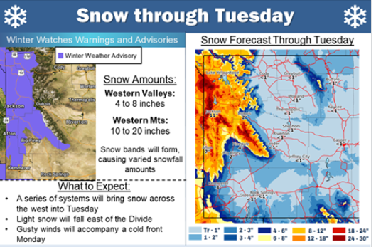
...Snow returning to Western Wyoming...
.A Pacific front will bring periods of snow to Western Wyoming
from tonight through Sunday night.
Star Valley-Salt River and Wyoming Ranges-
Including the cities of Afton, Alpine, Star Valley Ranch,
and Thayne
241 PM MST Sat Feb 9 2019
...WINTER WEATHER ADVISORY IN EFFECT FROM 6 PM THIS EVENING TO
11 PM MST SUNDAY...
* WHAT...Snow expected. Total snow accumulations of 3 to 6 inches
expected in the Star Valley. 6 to 10 inches in the Salt and
Wyoming Range.
* WHERE...Star Valley and Salt River and Wyoming Ranges.
* WHEN...From 6 PM this evening to 11 PM MST Sunday. The heaviest
snow is expected Sunday afternoon and Sunday evening.
* ADDITIONAL DETAILS...Travel could be very difficult. The cold
wind chills as low as 20 below zero could cause frostbite on
exposed skin in as little as 30 minutes.
PRECAUTIONARY/PREPAREDNESS ACTIONS...
A Winter Weather Advisory for snow means periods of snow will
cause primarily travel difficulties. Expect snow covered roads
and limited visibilities, and use caution while driving.
The latest road conditions for the state you are calling from can
be obtained by calling 5 1 1.
Following is a link to:
Winter Weather Briefing NWS RIverton
National Weather Service Riverton WY
241 PM MST Sat Feb 9 2019
...Snow returning to Western Wyoming...
.A Pacific front will bring periods of snow to Western Wyoming
from tonight through Sunday night.
Star Valley-Salt River and Wyoming Ranges-
Including the cities of Afton, Alpine, Star Valley Ranch,
and Thayne
241 PM MST Sat Feb 9 2019
...WINTER WEATHER ADVISORY IN EFFECT FROM 6 PM THIS EVENING TO
11 PM MST SUNDAY...
* WHAT...Snow expected. Total snow accumulations of 3 to 6 inches
expected in the Star Valley. 6 to 10 inches in the Salt and
Wyoming Range.
* WHERE...Star Valley and Salt River and Wyoming Ranges.
* WHEN...From 6 PM this evening to 11 PM MST Sunday. The heaviest
snow is expected Sunday afternoon and Sunday evening.
* ADDITIONAL DETAILS...Travel could be very difficult. The cold
wind chills as low as 20 below zero could cause frostbite on
exposed skin in as little as 30 minutes.
PRECAUTIONARY/PREPAREDNESS ACTIONS...
A Winter Weather Advisory for snow means periods of snow will
cause primarily travel difficulties. Expect snow covered roads
and limited visibilities, and use caution while driving.
The latest road conditions for the state you are calling from can
be obtained by calling 5 1 1.
Following is a link to:
Winter Weather Briefing NWS RIverton