National Weather Service Riverton WY
859 PM MDT Fri Sep 20 2019
...Significant Mountain Snowfall across the Western Mountains
through Saturday...
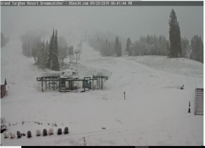
.A fall storm system will bring mountain snowfall to western
Wyoming through the day Saturday. The heaviest snowfall is
expected through late this evening. The snow is expected to
linger through the day Saturday before tapering off Saturday
evening.
Salt River and Wyoming Ranges-
859 PM MDT Fri Sep 20 2019
...WINTER WEATHER ADVISORY REMAINS IN EFFECT UNTIL NOON MDT
SATURDAY...
* WHAT...Periods of snow, heavy at times. The heaviest snowfall
will occur through this evening.
* SNOW AMOUNTS...4 TO 8 inches above 8500 feet with isolated
higher amounts above 10000 feet.
* WHERE...Salt River and Wyoming Ranges.
* WHEN...Until noon MDT Saturday.
* IMPACTS...Salt River Pass is expected to remain wet during this
event, but could become slick at times by late tonight.
Hypothermia could be an issue for those in the backcountry
unprepared for the cold and wet weather.
* ADDITIONAL DETAILS...Snowfall rates up to 2 inches per hour
could occur briefly through this evening. This will cause near
zero visibility in the mountains.
PRECAUTIONARY/PREPAREDNESS ACTIONS...
Slow down and use caution while traveling.