Thanksgiving Weekend Travel Will Be Greatly Weather Impacted
Star Valley is assured of a white Thanksgiving, however particularly strong November storms will primarily impact areas to the south and east. Travelers heading out for Thanksgiving should be weather aware. Following is a good summary of what is expected the next 5 days from the Weather Company.
Thanksgiving Travel Headaches Likely Across U.S.; Multiple Storms Expected From Coast to Coast
More than 55 million travelers are expected to travel 50 miles or more from their homes for the holiday, according to AAA. This makes it the second-highest Thanksgiving travel volume since AAA began tracking in 2000, behind only the record set in 2005.
(MORE: What Are the Odds of Snow on Thanksgiving?)
Here is our latest thinking on the forecast through the holiday weekend.
Tuesday’s Outlook
One low-pressure system should be located over the Midwest, while a second system will push ashore into the West Coast Tuesday into Tuesday night.
Travel Concerns: Weather-related travel delays are likely for much of the Midwest into the lower Mississippi Valley, as well as in parts of the Rockies and from Central California to the Pacific Northwest.
Northeast: Dry conditions are anticipated during the day, with rain possibly developing Tuesday night in the interior Northeast. Highs will be warmer than average.
South: Rain and thunderstorms are possible from the lower Mississippi Valley into the Deep South. Most of the Southeast will remain dry Tuesday, with some showers developing Tuesday night. A few thunderstorms could turn severe in the lower and mid-Mississippi valleys.
Midwest: Wind-driven snow will spread from the Central Plains to the upper Mississippi Valley and northern Great Lakes Tuesday into Tuesday night. Dangerous travel conditions will exist in these areas due to low visibility and slick roads. Rain is likely from the mid-Mississippi Valley into the southern Great Lakes Tuesday and will spread into the Ohio Valley and the rest of the Great Lakes by Tuesday night.
West: Snow will continue in parts of the central Rockies, while rain, mountain snow and strong winds will increase from Central California into the Northwest. The most dangerous travel conditions, including on Interstate 5 and Interstate 80, will be in southwestern Oregon and Northern California.
(MORE: Pre-Thanksgiving Snowstorm Ahead)
 Tuesday’s Forecast
Wednesday’s Outlook
One storm system will affect the East as two other weather systems converge on the West and Southern Plains.
Travel Concerns: Scattered rain showers could dampen travel in the East. Windy conditions in the Great Lakes and Northeast might cause airport delays. Rain is expected in the lower elevations of California, as well as in the Southwest. Snow will slicken roads from the Sierra Nevada of California to the interior West.
Northeast: Rain showers and gusty winds might cause some airport delays in parts of the Northeast.
South: Rain showers will spread across the Southeast. Some air-travel delays are possible in Atlanta, particularly early in the day. A separate area of rain will impact road travel in the Southern Plains.
Midwest: Strong winds could cause airport delays in the Great Lakes region, including Chicago. Snow and wind will create dangerous travel conditions in the upper Mississippi Valley and northern Great Lakes. Rain showers and gusty winds should spread across the Ohio Valley and southern Great Lakes.
West: An expansive, cold storm will bring rain and low snow levels to California, as well as parts of the Great Basin and Rockies. Air- and road-travel delays are possible in San Francisco and Los Angeles. Snow will create dangerous travel conditions from California’s Sierra Nevada into the Rockies.
(MORE: America’s 10 Most Weather-Delayed Major Airports)
 Wednesday’s Forecast
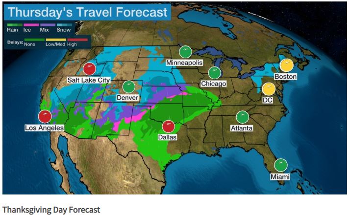
Thanksgiving Day Outlook
An expansive storm system will impact travel on Thanksgiving Day in the West and Plains.
Travel Concerns: Rain and snow could cause travel problems from California into the Rockies and Plains. Lingering wind might cause airport delays in the Northeast.
Northeast: Gusty winds from low pressure tracking toward Atlantic Canada could create delays at some Northeast airports. That system might also bring lingering snow showers to parts of northern New England and upstate New York.
South: Portions of the Southern Plains could experience wet roads as scattered showers move through. The Southeast will see dry travel as high pressure moves over the region.
Midwest: Snow ice might slicken roads in the Northern and Central Plains. Rain could dampen roads from the mid-Mississippi Valley into the lower Ohio Valley.
West: Snow will fall down to valley floors of the interior West, including Salt Lake City. Parts of the Desert Southwest and California will receive more rain and higher-elevation snow. Locally heavy rain is possible in thunderstorms in Southern California. Snow could affect travel on Interstate 5 through the Grapevine and Interstate 15 through Cajon Pass in Southern California. Interstate 8 through the San Diego County mountains could receive snowfall by Thursday night.
(MORE: Could Strong Winds Ground Balloons at Macy’s Thanksgiving Day Parade?)
 Thanksgiving Day Forecast
Friday’s Outlook
The large storm system will move eastward and affect travel from the Rockies to the Plains and Midwest.
Travel Concerns: Snow and strong winds could cause travel problems from the Southwest and Rockies northeastward into the Northern Plains and upper Midwest. Rain is expected from the Central and Southern Plains into parts of the Mississippi Valley and lower Ohio Valley. Severe thunderstorms may threaten the Southern Plains.
Northeast: Dry weather is expected across the entire Northeast as high pressure dominates.
South: The Southeast and northern Gulf Coast should stay dry. Severe thunderstorms with damaging winds, large hail and a few tornadoes could erupt in the Southern Plains, including from south-central Kansas to Oklahoma and north-central Texas.
Midwest: Snow and ice will impact travel in the Northern Plains and upper Midwest, with rain likely from the Central Plains into parts of the Mississippi Valley and Ohio Valley.
West: Snow will fall across much of the Rockies. The Pacific Northwest and much of California should stay dry. Rain showers are possible in far Southern California, with snow showers possible in the Sierra Nevada.
 Friday’s Forecast
Saturday’s Outlook
The storm system will continue to move eastward and may cause travel delays in the central and eastern U.S. A new storm will approach the West Coast.
Travel Concerns: Snow and wind could cause travel problems in parts of the Northern Plains, upper Midwest, northern Great Lakes and interior Northeast. Showers and thunderstorms are possible from the Southern Plains into the Mississippi Valley and parts of the mid-Atlantic and South.
Northeast: Much of the region should stay dry, but a few rain or snow showers are possible in Pennsylvania and western New York. Rain showers are also possible in portions of the mid-Atlantic. Wintry weather may increase in other parts of the Northeast Saturday night.
South: Parts of the South could experience wet roads as showers and storms move through the region. Coastal portions of the Southeast will likely be dry.
Midwest: Snow and wind will create hazardous travel conditions in the Northern Plains, upper Midwest and northern Great Lakes. Blizzard conditions are possible in the Northern Plains. The Ohio and Mississippi valleys may have to contend with rain showers.
West: A new weather system may approach California. Snow is possible in parts of the Sierra Nevada, with rain showers at lower elevations of Northern and Central California. The Pacific Northwest will likely have a dry day as weak high pressure takes control, with the exception of Oregon, where rain or snow showers are possible.
 Saturday’s Forecast
Sunday’s Outlook
An area of low pressure will move into the East, where it may cause travel delays in the form of wet or snow-covered roads and flight delays.
Travel Concerns: Snow could cause travel problems from the upper Midwest to New England. Rain is possible from the mid-Atlantic to the Southeast.
Northeast: Snow is forecast in parts of the region, particularly from New York state into New England. The precipitation will likely fall as rain in the mid-Atlantic states. A rain-and-snow mixture is possible in between those two areas, but exact details are uncertain.
South: Rain is expected across much of the Southeast, leading to wet roadways.
Midwest: Lingering snow may cause travel issues in the upper Midwest and Great Lakes, but it should be a dry day in the Plains.
West: Snow remains possible in parts of the Sierra Nevada, with rain showers at lower elevations of Northern and Central California. A few rain or snow showers may spread into the Pacific Northwest as well. Snow showers are also possible in parts of the Great Basin.
 Sunday’s Forecast
The Weather Company’s primary journalistic mission is to report on breaking weather news, the environment and the importance of science to our lives. This story does not necessarily represent the position of our parent company, IBM.
The Weather Company’s primary journalistic mission is to report on breaking weather news, the environment and the importance of science to our lives. This story does not necessarily represent the position of our parent company, IBM.