URGENT - WINTER WEATHER MESSAGE
National Weather Service Riverton WY
1118 AM MST Sun Jan 3 2021
...Winter Storm Watch for the far Western Wyoming late Monday
Afternoon through Tuesday Afternoon...
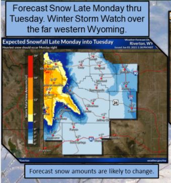
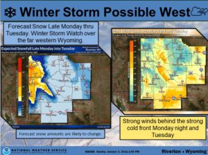
.The current round of light to moderate snow over the far west
will dissipate to very light snow or flurries by mid-evening. A
stronger storm system will impact western Wyoming late Monday
afternoon and Monday night, before exiting the area Tuesday
afternoon. Widespread significant snowfall over the west is
likely with this storm system.
WYZ023-024-041300-
/O.NEW.KRIW.WS.A.0001.210104T2200Z-210105T2200Z/
Star Valley-Salt River and Wyoming Ranges-
Including the cities of Afton, Alpine, Star Valley Ranch,
and Thayne
1118 AM MST Sun Jan 3 2021
...WINTER STORM WATCH IN EFFECT FROM MONDAY AFTERNOON THROUGH
TUESDAY AFTERNOON...
* WHAT...Heavy snow possible. Total snow accumulations of 4 to 8
inches in the lower elevations and 10 to 14 inches in
surrounding mountains. Winds could gust as high as 50 mph in the
mountains.
* WHERE...Star Valley and Salt River and Wyoming Ranges.
* WHEN...From Monday afternoon through Tuesday afternoon.
* IMPACTS...Travel could be difficult. Areas of blowing snow in
combination with heavier snow could lead to near whiteout
conditions mainly in the mountains.
* ADDITIONAL DETAILS...Hikers and snowmobilers could become
disoriented and lost due to very poor visibility.
PRECAUTIONARY/PREPAREDNESS ACTIONS...
Monitor the latest forecasts for updates on this situation.
Please monitor the Bridger-Teton Avalanche Center at
JHAVALANCHE.ORG, if your plans include travel into the back
country.
The latest road conditions for the state you are calling from can
be obtained by calling 5 1 1.