Pattern Change Over The Western States
A significant change in the storm track is taking place over the Western States for the coming week. Star Valley has been protected from storms for much of December by high pressure. While the skies have been generally clear the valley temperature inversions have been pronounced,. In Star Valley this has resulted in continued cold conditions overnight with lows below zero and afternoon high remaining in the teens., In the Cokeville area afternoon highs have not climbed out of the single digits over the weekend. Not the case above the valley floor, as the station at Star Valley Ranch warmed into the middle 20s and reminded well above zero at night. And just to the east at the Box Y Ranch along the Greys River maximums have been near freezing.
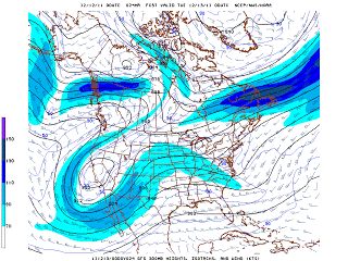
The high pressure which has been protecting much of the west has broken down and a new storm track is being established well to the south of Star Valley across the desert southwest.By Monday evening a large low pressure center will have developed over Southern California.
 |
| 300 mb Forecast Monday Evening 12/12/2011 |
While this system will bring considerable precipitation, rain in the valleys and snow in the higher elevations of the Southwest, it will have minimal effects on Star Valley for the next few days. In fact the increase in clouds with the southwesterly flow ahead of the low will tend to lessen the strong overnight cooling allowing temperatures to generally remain above zero for much of the week. Additionally afternoon highs will approach freezing even on the valley floor as warmer air mixes down with an increase in the winds aloft.
With regards to snow, chances will remain low until mid week. Additional disturbances will be moving inland at that time, however model forecasts continue to take most of the effects to the south of southeastern Idaho and western Wyoming. Some light snow will be possible most days after Wednesday but any major snow event seems unlikely through next weekend.