Spring Arrives with A Beautiful Weather Week Ahead in Star Valley
After a return this past weekend to winter with several inches of snow across Star Valley, the first full week of Spring promises to be a keeper. The deep cold trough of low pressure parked across the west will be replaced by high pressure and generally clear skies for much of the work week. With the strong late March sun, temperatures will respond.
Tuesday started cold with Thayne Elementary dipping to zero, for possibly the last time this season. By Wednesday and continuing into the weekend, afternoons will warm into the 50s, making serious enrodes on the remaining v alley snow pack. By Friday a mild southwesterly flow will be established across the Mountain West with a deep low pressure trough off the west coast.
 |
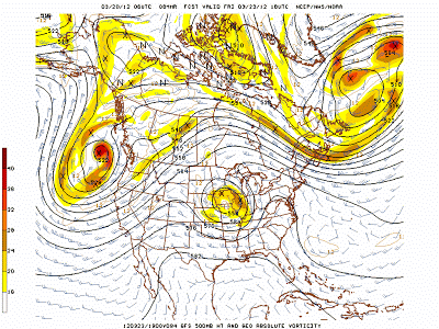
||
| 500 mb Forecast Friday Noon 3/23/12 |
By Sunday the trough begins to move inland but still appears that to have little affect on the weather of Star Valley other than some increase in clouds and shower potential by Sunday.
 |
| 500 mb Forecast midday Sunday 3/25/12 |
The longer range temperature forecast from the Climate Prediction center well into next week indicates that the abnormally warm conditions that have prevailed across much of the United States will persist.

With the snow pack in the nearby mountains now about average or a little above, some serious runoff could commence down the rivers in the next couple of weeks given this pattern.
 |
| Willow Creek SNOTEL |