Strong Front Passing Through Star Valley Monday Afternoon
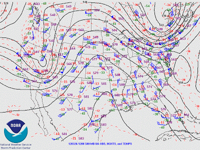
A vigorous upper trough is moving rapidly northeastward across Nevada and Utah Monday morning and will drive a strong cold front through Star Valley early this afternoon. The mornings 500mb analysis shows the impressive upper trough.
 |
||
| 500 mb analysis 6am mdt 3/26/12 |
The infrared satellite imagery clearly show the band of clouds
and associated precipitation approaching Star Valley from the south and
west as of 9:30 am this morning.

The cold front will cross Star Valley early this afternoon and be accompanied by strong gusty winds possibly up to 50 mph. A band of briefly heavy snow will be associated with the front and last for about an hour Total accumulations should remain less than 2 inches in the valley, however the combination of strong winds and snow will result in a period of restricted visibilities on the highways. Snow showers will continue into the evening hours but mostly end by sunset.
Lightning is being detected with the front as it crosses northern Utah this morning. This supports the idea of briefly heavy thunder snow as the front crosses the valley this afternoon. At 10am the cold front was just passing through Pocatello southeastward to Bear Lake.