Active Weather Pattern Returning to Wyoming
After a period of unseasonably pleasant weather across much of the Cowboy state a more typical springtime pattern is returning to Wyoming. The first system that brought upwards of a half inch of much needed rain to Star Valley Friday, also produced the first significant severe thunderstorm event of the year in the Riverton/Lander area during the afternoon. Gusts of winds above 70mph, lots of small hail and very heavy rain accompanied a line of thunderstorms that moved off the Wind Rivers by mid afternoon.
Riverton WFO provided documentation of the event which can be accessed through this link
http://www.crh.noaa.gov/news/display_cmsstory.php?wfo=riw&storyid=83249&source=0
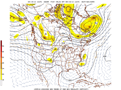
Following is a series of 500mb forecast charts for the next several days which shows the transitory ridge of high pressure that will bring a couple of days of very nice weather, followed by a series of systems accompanying a strong Pacific jet storm that moves into the Western States.
 |
||
| 500 mb Analysis Saturday Morning 5/19/12 |
 |
||
| 500 mb Forecast Monday Morning 5/21/12 |
 |
|||||||
| 500 mb Forecast Tuesday evening 5/22/12 |
 |
||
| 500 mb Forecast Thursday evening 5/24/12 |
While it is too soon to confidently provide detailed forecasts for when and how much precipitation will develop with this pattern change, it certainly supports a cool and wet period across Star Valley and much of Wyoming beginning by later Tuesday into the coming weekend. Snow will return to the mountains by mid week. Even Star Valley could see some wet snow, possibly as soon as later Wednesday.