Finally?
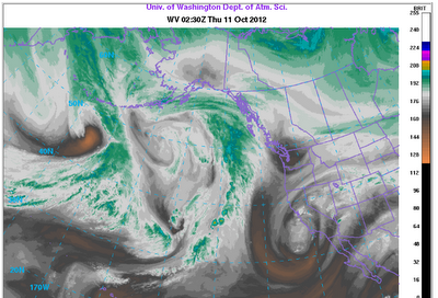
There is now enough confidence in the computer models to provide hope that Star Valley will finally see precipitation in the near future. The large upper high that has been located over the Gulf of Alaska, blocking the storm track from entering the western U.S. is in the process of breaking down and allowing a strong westerly flow of moist air from the Pacific to move inland this weekend. Ahead of this change an upper low is currently moving inland over California. This Wednesday evening satellite water vapor photo shows this feature.

Overlaying the 500 mb analysis not only can be noted the upper low but several upstream systems moving across the Northeastern Pacific.
 |
|
| 500mb analysis and Wednesday evening ir photo |
While the California upper low will move inland and cross the western states the next couple of days, it appears that much of the precipitation will remain just south of Star Valley. There is the chance of a few showers as far north as Star Valley later Friday/Friday night.
However the storm track is expected to become established across the Northwestern states, including Star Valley by late this weekend and early next week.
This change can best be noted in the series of 300mb level charts.
 |
|
| 300mb analysis Wed evening 10/10/12 |
 |
| 300mb forecast Sunday evening 10/14/12 |
 |
||
| 300mb forecast Tue evening 10/16/12 |
Models all agree that a very moist flow will accompany the jet which suggests a strong topographic factor in the precipitation potential. The forecast precipitable water for Monday shows the high amounts moving onto the west coast toward western Wyoming.
 |
|
| Precipitable Water Mon evening 10/15/12 |
The forecast precipitation that the model generates for the period over the weekend ending next Tuesday shows both the area that accompanys the California upper low, mostly to the south of Star Valley and the significant rainfall on the Northwest coast which spreads inland toward and north of Star Valley.
 |
| Total precipitation forecast ending Tuesday 10/16/12 |
While it is still too soon to predict the amount of rainfall that will fall in Star Valley, it is becoming more favorable for rain and wet snow in the higher elevations due to the strong orographic influences of the strong westerly flow. Mild temperatures should continue with snow confined to the higher elevations through early in the coming week.