Be Prepared for A Winter Blast
The major winter blast is still on schedule for this coming week. Snow, likely several inches in the Valley and a foot or more in the higher elevations will precede the turn to bitter cold temperatures by mid week. The storm is located over Alaska this Saturday morning, but will make a sharp right turn and head toward the Northern Rockies and Wyoming.
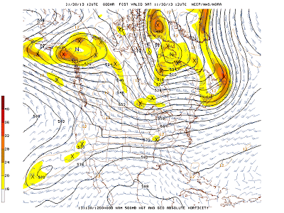
Here are a series of 500 mb charts showing the big change in pattern taking place over the next few days.
 |
| Saturday Morning Nov 30 2013 |
 |
| Monday Morning Dec. 2 2013
|
 |
| Tuesday Evening Dec. 3 2013 |
While the snow could be substantial, particularly in the higher elevations, the real story will be the bitter cold. By mid week, daytime temperatures will likely remain in the single digits, even in the Valley. with overnight lows dropping well below zero. Once the cold air arrives, the snow should diminish and then end and skies could clear. This could potentially lead to low temperatures in Star Valley dipping to minus 20 or even lower later in the week. The pattern is expected to remain favorable for the bitter cold to remain through next weekend.
Following is a link to the lastest advisories being issued by the Riverton Forecast Office.