Snow Returns this Weekend
SYNOPSIS: After a couple of mild days, a series of Canadian Cold Fronts will push southward across the state beginning Friday morning. Snow, possibly mixed with rain at times, will then push southward during the day Friday. Widespread snow will be found across the state by late Friday afternoon or early Friday evening. Another cold front will then bring the next round of snow, beginning Saturday morning. Snow could then continue through the day Saturday, and linger through Saturday night. Snow will then generally diminish from north to south Sunday morning, however, could linger across far southern Wyoming during the daytime hours. Very cold air is then expected behind these fronts, with high temperatures struggling to get into the mid to upper teens on Sunday for areas east of the divide. No matter your plans for the weekend, make sure to check for the latest forecasts and hazards for this winter storm. Many of the latest forecast details can be found below.
IMPACTS: For anyone traveling this weekend, expect snow and wind to create slick roads and difficult driving conditions at times. Those with outdoor interests should also be prepared for drastically changing weather conditions along with moderate to heavy snow, especially across the Wind River, Absaroka, and Bighorn Mountains.
SNOW ACCUMULATIONS: Daytime accumulations on Friday will generally remain light across the lower elevations east of the divide. The mountains of central and northern Wyoming could see moderate to heavy snow at times on Friday and thorugh the weekend. The second front that pushes through Saturday will then bring widespread measurable snow to most areas. Overall new snow accumulations by Sunday morning of 1 to 2 feet across the central and northern mountains will be possible, with 2-6 inches across the lower elevations east of the divide, and 1-5 inches across the lower elevations west of the divide. Areas near Lander could also see locally higher amounts of 5-10 inches by Sunday morning.
 |
 |
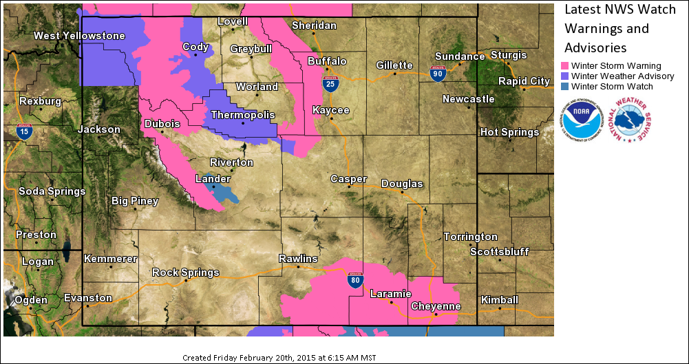
| Click Image To Enlarge Current Advisories
Bighorn Mountains, Absaroka Mountains, and eastern Wind River Mountains Winter Storm Warning valid through 5 AM Sunday morning (Absaroka Mountains expires at 5 PM Saturday evening).
Lander Foothills Winter Storm Watch from 5 AM Saturday morning through 5 AM Sunday morning.
Yellowstone National Park, Cody Foothills, Owl Creek and Bridger Mountains, and southwest Bighorn Basin Winter Weather Advisory from 5 PM Friday evening through 5 PM Saturday evening (Yellowstone National Park expires 5 AM Saturday morning).
Click or scroll down to “Forecast” to find the latest Watches, Warnings, and Advisories.
|
Click Image To Enlarge
Friday Through Sunday Evening Snow Forecast
Storm Totals For Selected Areas
Riverton Area: 3-5″ |
 |
 |
| Click Loop To Enlarge
Model Depiction of Temperature (background image) & Wind (arrows, the longer the tail of the arrow, the stronger the wind) at the 10kft level and Precipitation (spotty image).
The loop advances in 6 hour time steps, beginning at 5 am Friday and ending on Monday at 5am. The time stamp in the bottom right hand corner shows the valid time in “Z Time” (where 00Z = 5pm and 12Z = 5am MST)
|
Click Image To Enlarge
Cold air to return Sunday: This image shows the forecasted High Temperatures for Sunday. Notice how highs will struggle to get out of the teens.
Click or scroll down to “Forecast” to find the latest high and low temperature maps. |
Travel is expected to be adversely impacted with Interstate delays or closures expected, several passes and side roads could also see extended times of difficult travel and/or closures as well. If you plan to travel this weekend, especially Friday night and Saturday, then we recommend checking the conditions along your route and staying on top of road closures here. If you are on Twitter, follow the hashtag: #WyoRoad for the latest weather affecting roads and road conditions in and around Wyoming.
 |