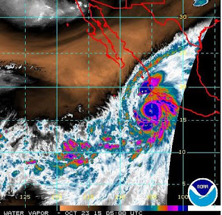
Hurricane PATRICIA Public Advisory
Possibly the strongest Hurricane ever recorded is heading for the coast of
southwest Mexico on Friday
BULLETIN
HURRICANE PATRICIA SPECIAL ADVISORY NUMBER  13
NWS NATIONAL HURRICANE CENTER MIAMI FL
1230 AM CDT FRI OCT 23 2015
...CATEGORY 5 HURRICANE PATRICIA STRENGTHENS EVEN MORE...
...POTENTIALLY CATASTROPHIC LANDFALL IN SOUTHWESTERN MEXICO LATER
TODAY...


SUMMARY OF 1230 AM CDT...0530 UTC...INFORMATION
-----------------------------------------------
LOCATION...16.5N 105.3W
ABOUT 185 MI...295 KM SSW OF MANZANILLO MEXICO
ABOUT 270 MI...435 KM S OF CABO CORRIENTES MEXICO
MAXIMUM SUSTAINED WINDS...185 MPH...295 KM/H
PRESENT MOVEMENT...NNW OR 330 DEGREES AT 10 MPH...17 KM/H
MINIMUM CENTRAL PRESSURE...892 MB...26.34 INCHES


WATCHES AND WARNINGS
--------------------
CHANGES WITH THIS ADVISORY:

None

SUMMARY OF WATCHES AND WARNINGS IN EFFECT:

A Hurricane Warning is in effect for...
* San Blas to Punta San Telmo

A Hurricane Watch is in effect for...
* East of Punta San Telmo to Lazaro Cardenas

A Tropical Storm Warning is in effect for...
* East of Punta San Telmo to Lazaro Cardenas

A Hurricane Warning means that hurricane conditions are expected
somewhere within the warning area, in this case within about 24
hours. Preparations to protect life and property should be rushed to
completion.

A Tropical Storm Warning means that tropical storm conditions are
expected somewhere within the warning area.

A Hurricane Watch means that hurricane conditions are possible
within the watch area.

For storm information specific to your area, please monitor
products issued by your national meteorological service.


DISCUSSION AND 48-HOUR OUTLOOK
------------------------------
At 1230 AM CDT (0530 UTC), the eye of Hurricane Patricia was
located near latitude 16.5 North, longitude 105.3 West.  Patricia
is moving toward the north-northwest near 10 mph (17 km/h). A turn
toward the north is expected later this morning, followed by a turn
toward the north-northeast this afternoon.  On the forecast track,
the core of Patricia will make landfall in the hurricane warning
area this afternoon or evening.

Reports from an Air Force Reserve Unit Hurricane Hunter aircraft
indicate that the maximum sustained winds have increased to near 185
mph (295 km/h) with higher gusts.  Patricia is a category 5
hurricane on the Saffir-Simpson Hurricane Wind Scale.  Some
fluctuations in intensity are possible today, but Patricia is
expected to remain an extremely dangerous category 5 hurricane
through landfall.

Hurricane force winds extend outward up to 35 miles (55 km) from the
center and tropical storm force winds extend outward up to 175 miles
(280 km).

The minimum central pressure estimated from Hurricane Hunter
observations is 892 mb (26.34 inches).


HAZARDS AFFECTING LAND
----------------------
WIND:  Hurricane conditions are expected to first reach the
hurricane warning area this afternoon.  Tropical storm conditions
are expected to first reach the warning areas early today,
making outside preparations difficult or dangerous.  Preparations to
protect life and property should be rushed to completion. Hurricane
conditions are possible in the hurricane watch area late today.

RAINFALL:  Patricia is expected to produce total rainfall
accumulations of 6 to 12 inches, with isolated maximum amounts of 20
inches, over the Mexican states of Jalisco, Colima, Michoacan and
Guerrero through Saturday.  These rains could produce
life-threatening flash floods and mud slides.

STORM SURGE:  An extremely dangerous storm surge is expected to
produce significant coastal flooding near and to the right of where
the center makes landfall.  Near the coast, the surge will be
accompanied by large and destructive waves.

SURF:  Swells generated by Patricia are already affecting portions
of the southern coast of Mexico, and will spread northwestward
during the next day or so.  These swells are likely to cause
life-threatening surf and rip current conditions. Please consult
products from your local weather office.


NEXT ADVISORY
-------------
Next complete advisory at 400 AM CDT.
|

