Wild Weather Affects Much of United States and England
U.S. Reeling From Violent Tornadoes, Epic Flooding, Winter Weather, and Weird Heat
By: Bob Henson and Jeff Masters , 10:54 PM GMT on December 28, 2015
Wild weather continued to plaster the nation’s midsection on Monday as a multi-barreled storm system shifted eastward. Thankfully, the severe weather threat has ramped down somewhat, with the highest risks now shifting to river and flash floods–from eastern Oklahoma to the Appalachians–and snow and ice, from Nebraska to New England. More than 40 weather-related deaths have been reported since Wednesday. The storminess is related to a gradual realignment of the large-scale pattern over North America, as described in detail by wunderblogger Steve Gregory in his Monday afternoon post. A stunningly warm, moist air mass across the eastern and southern U.S.–by some measures the most tropical on record for early winter–is in the process of being displaced by a strong upper-level storm moving into the central states, bringing much more seasonable cold.

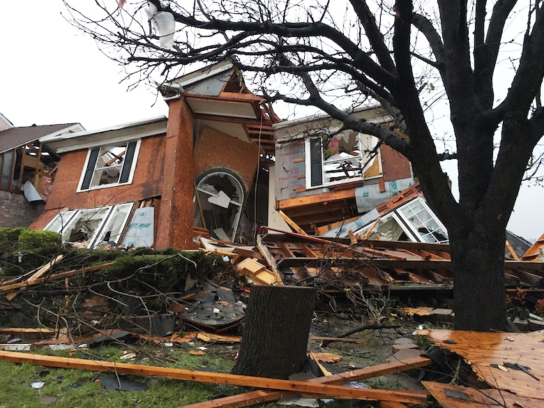
Figure 1. Damage from the tornado that struck Rowlett, Texas, on Saturday evening, December 26, 2015. The tornado was rated at least EF3. Image credit: AP Photo/David Warren.
North Texas cleans up from Saturday’s deadly tornadoes
Ahead of a strong cold front in west Texas, supercell thunderstorms that ripped across the sprawling eastern part of the Dallas area spawned several tornadoes that killed at least 11 people. One violent tornado that killed eight people in Garland was rated EF4, while “at least EF3” damage was found in Rowlett, just east of Garland, due to the same tornado or one that closely followed. Two people died in Copeland, about 15 miles to the northeast, where EF2 damage was documented. Several other weaker tornadoes struck North Texas. According to the Dallas Morning News, as many as 1000 structures were damaged across north Texas, many of them severely. The storms were fed by a very strong upper-level jet as well as unusually high instability for December (around 3000 joules per kilogram, which would be concerning in springtime, much less wintertime).Temperatures reached 80°F in Dallas just hours before the tornadic supercell arrived, with a summerlike dew point of 67°F.
The widespread persistence of warm, humid conditions over the last few days has led to an unusual U.S. stretch of severe weather for December, including tornadoes from Mississippi to Michigan on Wednesday. The EF1 tornado that touched down in Canton, Michigan on December 23 was Michigan’s first December tornado on record. If tornadoes are confirmed on Monday, it will be the sixth calendar day in a row with at least one U.S. tornado reported, tying a monthly record set on December 22-27, 1982, during the “super El Niño” of 1982-83. (The streak would be even longer if we counted early-morning tornadoes on December 23 as part of the December 22 “tornado day”, per NOAA recordkeeping.) Another tragic milestone: 2015 is the first year in records going back to 1875 that has seen more confirmed tornado-related deaths in December than in the rest of the year combined. The only other year with December having more deaths than any other single month was 1931, according to statistics analyzed by Harold Brooks (NOAA National Severe Storms Laboratory).

Figure 2. A 10” snowfall in Clovis, NM, resulted in drifts reaching 9 feet over the weekend, thanks to sustained winds that reached 45 mph with gusts reported to 82 mph at the Clovis airport. Fierce winds and blowing snow continued on Sunday, December 27, 2015. Image credit: wunderphotographer mneff267.
Winter weather shifting from High Plains to Midwest, Northeast
While severe weather rumbled across east Texas on Sunday, the western part of the state was dealing with a crippling blizzard that extended into eastern New Mexico, while freezing rain knocked out power to tens of thousands of western Oklahomans. Exceptionally strong winds–gusting above 70 mph in some areas–have led to near-zero visibilities and drifts of 6 feet or more, paralyzing travel across the region. Roswell, NM, had racked up 12.3” for the day by 8 pm CST Sunday, topping its one-day record of 11.5”; the two-day total of 15.5″ was approaching Roswell’s two-day record of 16.9”. Lubbock, TX, picked up 2.7” between 6 and 7 pm CST Sunday, pushing its storm total to 9.2”. The city’s heaviest-on-record storm total of 16.9” was picked up on January 20-21 during (you guessed it) the super El Niño of 1982-83.
As the upper-level storm and associated low head northeastward on Monday, more snow and ice is plastering a swath extending from Kansas and Nebraska to Wisconsin and Michigan. A mix of sleet, snow, and freezing rain is bedeviling parts of the Great Lakes, including the Chicago and Detroit areas. A band of heavier snow (6” to 12” in spots), coupled with freezing rain in some areas, is expected from northern Wisconsin into much of Maine.
Massive flooding hits Missouri and Illinois, killing 13
The weekend storm brought incredibly heavy rains to eastern Oklahoma, northwest Arkansas, and Southwest Missouri, with 10.0″ falling in a 30-hour period ending Sunday evening on the south side of Springfield, Missouri. The heavy rains drove rivers in Illinois, Missouri, Oklahoma, and Arkansas above major flood stage, with the Illinois River reaching its highest crest on record at two locations. On Sunday, Governor Jay Nixon declared a state of emergency in Missouri due to heavy flooding all across the state, and urged Missourians in flood-affected areas to not drive into flooded roadways and avoid travel if possible. Eight people died Saturday night in Missouri in floods; six of the deaths occurred in two separate incidents where cars drove into flooded roadways in Pulaski County and were swept away by water. In southern Illinois, three adults and two children drowned Saturday evening when their car was swept away and sank in a rain-swollen creek. Mercifully, the rains have ended in Missouri and dry weather is expected the rest of the week.

Figure 3. Observed precipitation amounts for the 3-day period ending on Monday, December 28, 2015, at 4 pm EST. Rainfall amounts of 6″+ were widespread across eastern Oklahoma, northwest Arkansas, southwest Missouri and central Illinois, with some areas seeing 10″+. Image credit: NOAA/NWS.
A historic flood is building on the Mississippi River
The updated flood forecasts for the Mississippi River issued Monday afternoon by NWS River Forecast Center are about two feet higher than the forecasts issued on Sunday. Nearly all of the Lower Mississippi is expected to enter major flood stage over the next few weeks, as are the lower portions of two main tributaries, the Ohio and Arkansas Rivers. The Mississippi River near St. Louis was already near flood stage late last week due to excessive rains of 2 – 4″ (400 – 600% of average) that fell during the past two weeks farther upstream in Iowa, Wisconsin, and Minnesota. A massive pulse of flood waters from the epic December 26 – 28 rains will pile into the Mississippi River over the next few days, bringing the river to flood levels that will be the highest on record outside of the usual spring to early summer flood season. The Mississippi River at St. Louis was at moderate flood stage on Monday afternoon, and is forecast to crest on Wednesday at the second highest level ever observed, just five feet below the all-time record set during the disastrous flood of 1993. Flood records at this location extend back to 1785. Downstream from St. Louis, the Mississippi River is forecast to crest late this week in Chester, Cape Girardeau, and Thebes at the highest levels ever recorded. NOAA warns that at the flood levels expected, the Degognia, Fountain Bluff, Stringtown, and Prairie DuRocher levees will be overtopped near Chester. NOAAprojects that the massive flood crest will propagate downstream to the Gulf of Mexico during the first three weeks of January, bringing flood heights that are expected to be between the 2nd highest and 4th highest on record all the way to Louisiana.

Figure 4. The Mississippi River just downstream of St. Louis at Chester was at moderate flood stage on Monday afternoon, and is forecast to crest on Thursday at the highest level ever observed–exceeding the disastrous flood of 1993. Flood records at this location extend back to 1844. Image credit: NOAA/AHPS.
On January 20, the flood crest is expected to arrive in New Orleans, bringing the Mississippi River to its 17-foot flood stage in the city, just 3 feet below the tops of the levees. In past years, though, when the river has been forecast to rise to 17 feet in the city, the Army Corps of Engineers has opened up the Bonnet Carre Spillway in St. Charles Parish, which diverts water into Lake Pontchartrain and keeps the river from reaching flood stage in New Orleans. The Corps may also be forced to open the Morganza Floodway in Pointe Coupee Parish, which would divert water down the Atchafalaya River. Opening this spillway has a considerably higher cost than opening the Bonnet Carre Spillway, due to the large amount of agricultural lands that would be flooded below the Morganza Floodway. The Corps also has the option of increasing the flow of Mississippi River water into the Atchafalaya at the Old River Control Structure in Concordia Parish. Operating the Old River Control Structure in this way always makes me nervous, as I explained in my 2011 blog post, America’s Achilles’ heel: the Mississippi River’s Old River Control Structure. The Monday afternoon forecast from the NWS River Forecast Center predicted that the Mississippi River would crest at Red River Landing, where the Old River Control Structure is located, on January 19. The predicted crest of 62.5′ is just 0.9′ below the all-time record crest of 63.39′ set on May 18, 2011. A water level this high has a good chance of forcing the Army Corps to open the Morganza Floodway in order to relieve pressure on the Old River Control Structure. Both the Bonnet Carre Spillway and Morganza Floodway were opened in May 2011, when the highest flood crests ever observed on the Lower Mississippi arrived. This flood cost over $2 billion; I expect the damage from the December 2015 – January 2016 Mississippi River flood will run into the hundreds of millions.

Figure 5. Existing flood stage on December 28, 2015 (inner colored square) and predicted maximum flood stage (outer colored square region around the inner colored square) for the Lower Mississippi River and two tributaries (the Arkansas and Ohio Rivers) near where they join the Mississippi. I’ve added a numerical ranking on the right side of the squares to indicate where a top-ten flood crest in recorded history is expected. Two gauges are expecting their highest floods on record (Cape Girardeau and Thebes), and most of the Lower Mississippi is expecting a top-five highest flood crest on record. Where the Ohio River joins the Mississippi at Cairo, Illinois, the Ohio River is forecast to crest on January 5 at the third highest level on record; downstream from Little Rock, Arkansas, the Arkansas River is predicted to crest on Friday at the third highest level on record near its confluence with the Mississippi. Image credit: NWS River Forecast Center.
Recapping the Big Christmas Warm
Hundreds of records were buried by sunshine, warmth, and humidity instead of white-Christmas snowfall all across the eastern U.S. during the holidays, especially on Thursday and Friday. Christmas Day was the apex for the north-south breadth of warmth, with record highs set from Florida (82°F in Jacksonville) to Maine (62°F in Portland). Many records on Thursday and Friday were smashed by margins of 10°F or more. The Christmas Eve readings of 72°F at Albany, NY, and 68°F at Burlington, VT, both set all-time records for December. As noted by WU weather historian Chris Burt, these are truly impressive records given the late date in a month that gets progressively colder, not to mention the long periods of record at both sites (since 1883 in Burlington and 1874 in Albany). Chris adds that Philadelphia has seen eight days this month through Sunday with record daily highs: “Not since records began in Philadelphia back in 1874 has any other month of any single year experienced as many daily record highs as this December!” The capital of Christmas commerce, New York City, basked in record warmth of 72°F on Thursday and 66°F on Friday. As of Sunday, Central Park had yet to get below 32°F this fall or winter; its monthly average (12/1 – 12/26) of 52.0°F was running at an astonishing 13.8°F above normal and 7.9°F above the previous December record, going back to 1871. A cooldown this week will reduce that value, but a warmest-on-record December is all but certain for much of the eastern U.S. It’s no wonder that flowers and shrubs are blossoming from Washington to New York.
For the period 12/1/ through 12/26, NOAA’s U.S. Records site shows a phenomenal 3879 daily record highs and 5301 record warm lows, compared to 166 record cold highs and 159 record lows. Despite the intense cold in the eastern U.S. early in 2015, this year will end up with more than two and a half times as many U.S. daily record highs as lows, just one more statistic for a year that is wrapping up in remarkable fashion.

Figure 6. Rescue teams wade through flood waters that have inundated homes in the Huntington Road area of York after the River Foss burst its banks, on Monday, December 28, 2015 in York, United Kingdom. Severe flooding has affected large parts of northern England, with homes and businesses in Yorkshire and Lancashire evacuated as rivers burst their banks. More heavy rain is forecast as dozens of severe flood warnings remain in place. Image credit: Jeff J. Mitchell/Getty Images.
Floods, holiday warmth extend to Britain and beyond
Northern England continues to deal with relentless bursts of rain and resulting floods. The accounting firm KPMGestimates the cost of the disruption to Britain’s economy at up to 5.8 billion pounds (roughly $8.6 billion US). More heavy rain is expected on Wednesday. The venerable Central England Temperature index–the world’s oldest continuous instrumented record of temperature–remains on track to set its warmest December reading in more than 350 years. The estimated average from 12/1 to 12/27 is at 9.8°C (49.6°F), which is 5.0°C (9.0°C) above the norm. Other European nations are also likely to set records for December warmth, including the Netherlands.
Figure 1. Damage from the tornado that struck Rowlett, Texas, on Saturday evening, December 26, 2015. The tornado was rated at least EF3. Image credit: AP Photo/David Warren.
North Texas cleans up from Saturday’s deadly tornadoes
Ahead of a strong cold front in west Texas, supercell thunderstorms that ripped across the sprawling eastern part of the Dallas area spawned several tornadoes that killed at least 11 people. One violent tornado that killed eight people in Garland was rated EF4, while “at least EF3” damage was found in Rowlett, just east of Garland, due to the same tornado or one that closely followed. Two people died in Copeland, about 15 miles to the northeast, where EF2 damage was documented. Several other weaker tornadoes struck North Texas. According to the Dallas Morning News, as many as 1000 structures were damaged across north Texas, many of them severely. The storms were fed by a very strong upper-level jet as well as unusually high instability for December (around 3000 joules per kilogram, which would be concerning in springtime, much less wintertime).Temperatures reached 80°F in Dallas just hours before the tornadic supercell arrived, with a summerlike dew point of 67°F.
The widespread persistence of warm, humid conditions over the last few days has led to an unusual U.S. stretch of severe weather for December, including tornadoes from Mississippi to Michigan on Wednesday. The EF1 tornado that touched down in Canton, Michigan on December 23 was Michigan’s first December tornado on record. If tornadoes are confirmed on Monday, it will be the sixth calendar day in a row with at least one U.S. tornado reported, tying a monthly record set on December 22-27, 1982, during the “super El Niño” of 1982-83. (The streak would be even longer if we counted early-morning tornadoes on December 23 as part of the December 22 “tornado day”, per NOAA recordkeeping.) Another tragic milestone: 2015 is the first year in records going back to 1875 that has seen more confirmed tornado-related deaths in December than in the rest of the year combined. The only other year with December having more deaths than any other single month was 1931, according to statistics analyzed by Harold Brooks (NOAA National Severe Storms Laboratory).
Figure 2. A 10” snowfall in Clovis, NM, resulted in drifts reaching 9 feet over the weekend, thanks to sustained winds that reached 45 mph with gusts reported to 82 mph at the Clovis airport. Fierce winds and blowing snow continued on Sunday, December 27, 2015. Image credit: wunderphotographer mneff267.
Winter weather shifting from High Plains to Midwest, Northeast
While severe weather rumbled across east Texas on Sunday, the western part of the state was dealing with a crippling blizzard that extended into eastern New Mexico, while freezing rain knocked out power to tens of thousands of western Oklahomans. Exceptionally strong winds–gusting above 70 mph in some areas–have led to near-zero visibilities and drifts of 6 feet or more, paralyzing travel across the region. Roswell, NM, had racked up 12.3” for the day by 8 pm CST Sunday, topping its one-day record of 11.5”; the two-day total of 15.5″ was approaching Roswell’s two-day record of 16.9”. Lubbock, TX, picked up 2.7” between 6 and 7 pm CST Sunday, pushing its storm total to 9.2”. The city’s heaviest-on-record storm total of 16.9” was picked up on January 20-21 during (you guessed it) the super El Niño of 1982-83.
As the upper-level storm and associated low head northeastward on Monday, more snow and ice is plastering a swath extending from Kansas and Nebraska to Wisconsin and Michigan. A mix of sleet, snow, and freezing rain is bedeviling parts of the Great Lakes, including the Chicago and Detroit areas. A band of heavier snow (6” to 12” in spots), coupled with freezing rain in some areas, is expected from northern Wisconsin into much of Maine.
Massive flooding hits Missouri and Illinois, killing 13
The weekend storm brought incredibly heavy rains to eastern Oklahoma, northwest Arkansas, and Southwest Missouri, with 10.0″ falling in a 30-hour period ending Sunday evening on the south side of Springfield, Missouri. The heavy rains drove rivers in Illinois, Missouri, Oklahoma, and Arkansas above major flood stage, with the Illinois River reaching its highest crest on record at two locations. On Sunday, Governor Jay Nixon declared a state of emergency in Missouri due to heavy flooding all across the state, and urged Missourians in flood-affected areas to not drive into flooded roadways and avoid travel if possible. Eight people died Saturday night in Missouri in floods; six of the deaths occurred in two separate incidents where cars drove into flooded roadways in Pulaski County and were swept away by water. In southern Illinois, three adults and two children drowned Saturday evening when their car was swept away and sank in a rain-swollen creek. Mercifully, the rains have ended in Missouri and dry weather is expected the rest of the week.
Figure 3. Observed precipitation amounts for the 3-day period ending on Monday, December 28, 2015, at 4 pm EST. Rainfall amounts of 6″+ were widespread across eastern Oklahoma, northwest Arkansas, southwest Missouri and central Illinois, with some areas seeing 10″+. Image credit: NOAA/NWS.
A historic flood is building on the Mississippi River
The updated flood forecasts for the Mississippi River issued Monday afternoon by NWS River Forecast Center are about two feet higher than the forecasts issued on Sunday. Nearly all of the Lower Mississippi is expected to enter major flood stage over the next few weeks, as are the lower portions of two main tributaries, the Ohio and Arkansas Rivers. The Mississippi River near St. Louis was already near flood stage late last week due to excessive rains of 2 – 4″ (400 – 600% of average) that fell during the past two weeks farther upstream in Iowa, Wisconsin, and Minnesota. A massive pulse of flood waters from the epic December 26 – 28 rains will pile into the Mississippi River over the next few days, bringing the river to flood levels that will be the highest on record outside of the usual spring to early summer flood season. The Mississippi River at St. Louis was at moderate flood stage on Monday afternoon, and is forecast to crest on Wednesday at the second highest level ever observed, just five feet below the all-time record set during the disastrous flood of 1993. Flood records at this location extend back to 1785. Downstream from St. Louis, the Mississippi River is forecast to crest late this week in Chester, Cape Girardeau, and Thebes at the highest levels ever recorded. NOAA warns that at the flood levels expected, the Degognia, Fountain Bluff, Stringtown, and Prairie DuRocher levees will be overtopped near Chester. NOAAprojects that the massive flood crest will propagate downstream to the Gulf of Mexico during the first three weeks of January, bringing flood heights that are expected to be between the 2nd highest and 4th highest on record all the way to Louisiana.
Figure 4. The Mississippi River just downstream of St. Louis at Chester was at moderate flood stage on Monday afternoon, and is forecast to crest on Thursday at the highest level ever observed–exceeding the disastrous flood of 1993. Flood records at this location extend back to 1844. Image credit: NOAA/AHPS.
On January 20, the flood crest is expected to arrive in New Orleans, bringing the Mississippi River to its 17-foot flood stage in the city, just 3 feet below the tops of the levees. In past years, though, when the river has been forecast to rise to 17 feet in the city, the Army Corps of Engineers has opened up the Bonnet Carre Spillway in St. Charles Parish, which diverts water into Lake Pontchartrain and keeps the river from reaching flood stage in New Orleans. The Corps may also be forced to open the Morganza Floodway in Pointe Coupee Parish, which would divert water down the Atchafalaya River. Opening this spillway has a considerably higher cost than opening the Bonnet Carre Spillway, due to the large amount of agricultural lands that would be flooded below the Morganza Floodway. The Corps also has the option of increasing the flow of Mississippi River water into the Atchafalaya at the Old River Control Structure in Concordia Parish. Operating the Old River Control Structure in this way always makes me nervous, as I explained in my 2011 blog post, America’s Achilles’ heel: the Mississippi River’s Old River Control Structure. The Monday afternoon forecast from the NWS River Forecast Center predicted that the Mississippi River would crest at Red River Landing, where the Old River Control Structure is located, on January 19. The predicted crest of 62.5′ is just 0.9′ below the all-time record crest of 63.39′ set on May 18, 2011. A water level this high has a good chance of forcing the Army Corps to open the Morganza Floodway in order to relieve pressure on the Old River Control Structure. Both the Bonnet Carre Spillway and Morganza Floodway were opened in May 2011, when the highest flood crests ever observed on the Lower Mississippi arrived. This flood cost over $2 billion; I expect the damage from the December 2015 – January 2016 Mississippi River flood will run into the hundreds of millions.
Figure 5. Existing flood stage on December 28, 2015 (inner colored square) and predicted maximum flood stage (outer colored square region around the inner colored square) for the Lower Mississippi River and two tributaries (the Arkansas and Ohio Rivers) near where they join the Mississippi. I’ve added a numerical ranking on the right side of the squares to indicate where a top-ten flood crest in recorded history is expected. Two gauges are expecting their highest floods on record (Cape Girardeau and Thebes), and most of the Lower Mississippi is expecting a top-five highest flood crest on record. Where the Ohio River joins the Mississippi at Cairo, Illinois, the Ohio River is forecast to crest on January 5 at the third highest level on record; downstream from Little Rock, Arkansas, the Arkansas River is predicted to crest on Friday at the third highest level on record near its confluence with the Mississippi. Image credit: NWS River Forecast Center.
Recapping the Big Christmas Warm
Hundreds of records were buried by sunshine, warmth, and humidity instead of white-Christmas snowfall all across the eastern U.S. during the holidays, especially on Thursday and Friday. Christmas Day was the apex for the north-south breadth of warmth, with record highs set from Florida (82°F in Jacksonville) to Maine (62°F in Portland). Many records on Thursday and Friday were smashed by margins of 10°F or more. The Christmas Eve readings of 72°F at Albany, NY, and 68°F at Burlington, VT, both set all-time records for December. As noted by WU weather historian Chris Burt, these are truly impressive records given the late date in a month that gets progressively colder, not to mention the long periods of record at both sites (since 1883 in Burlington and 1874 in Albany). Chris adds that Philadelphia has seen eight days this month through Sunday with record daily highs: “Not since records began in Philadelphia back in 1874 has any other month of any single year experienced as many daily record highs as this December!” The capital of Christmas commerce, New York City, basked in record warmth of 72°F on Thursday and 66°F on Friday. As of Sunday, Central Park had yet to get below 32°F this fall or winter; its monthly average (12/1 – 12/26) of 52.0°F was running at an astonishing 13.8°F above normal and 7.9°F above the previous December record, going back to 1871. A cooldown this week will reduce that value, but a warmest-on-record December is all but certain for much of the eastern U.S. It’s no wonder that flowers and shrubs are blossoming from Washington to New York.
For the period 12/1/ through 12/26, NOAA’s U.S. Records site shows a phenomenal 3879 daily record highs and 5301 record warm lows, compared to 166 record cold highs and 159 record lows. Despite the intense cold in the eastern U.S. early in 2015, this year will end up with more than two and a half times as many U.S. daily record highs as lows, just one more statistic for a year that is wrapping up in remarkable fashion.
Figure 6. Rescue teams wade through flood waters that have inundated homes in the Huntington Road area of York after the River Foss burst its banks, on Monday, December 28, 2015 in York, United Kingdom. Severe flooding has affected large parts of northern England, with homes and businesses in Yorkshire and Lancashire evacuated as rivers burst their banks. More heavy rain is forecast as dozens of severe flood warnings remain in place. Image credit: Jeff J. Mitchell/Getty Images.
Floods, holiday warmth extend to Britain and beyond
Northern England continues to deal with relentless bursts of rain and resulting floods. The accounting firm KPMGestimates the cost of the disruption to Britain’s economy at up to 5.8 billion pounds (roughly $8.6 billion US). More heavy rain is expected on Wednesday. The venerable Central England Temperature index–the world’s oldest continuous instrumented record of temperature–remains on track to set its warmest December reading in more than 350 years. The estimated average from 12/1 to 12/27 is at 9.8°C (49.6°F), which is 5.0°C (9.0°C) above the norm. Other European nations are also likely to set records for December warmth, including the Netherlands.