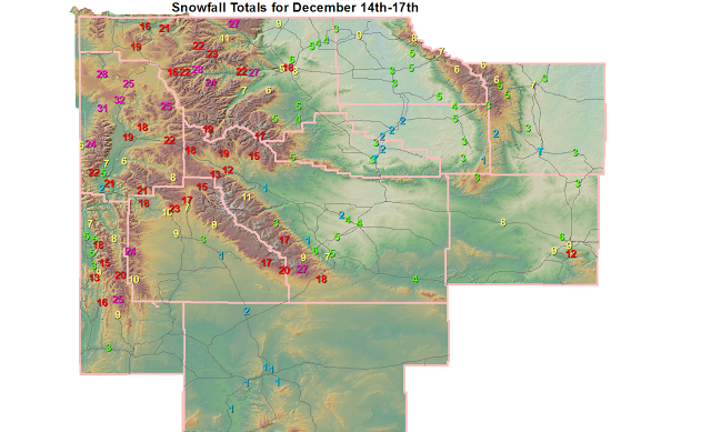
Lincoln County...
Blind Bull Summit... 25 inches.
Indian Creek Snotel... 25 inches.
Spring Creek Divide Snotel... 20 inches.
Commissary Ridge... 18 inches.
Willow Creek Snotel... 18 inches.
Kelley Ranger Station Snotel... 16 inches.
Cottonwood Creek Snotel... 15 inches.
Salt River Summit Snotel... 13 inches.
5 SSE Smoot... 9 inches.
Hams Fork Snotel... 9 inches.
Box Y Ranch... 8 inches.
Star Valley Ranch... 6.5 inches.
3 SE Bedford... 5 inches.
Afton... 4.8 inches.
2 SE Thayne... 4.5 inches.
Smoot... 3 inches.
Fossil Butte... 3 inches.
Big Horn County...
2 SSW Lovell... 10.5 inches.
Lovell... 8.5 inches.
Bald Mountain Snotel... 8 inches.
Bone Springs Divide Snotel... 7 inches.
Shell Creek Snotel... 6 inches.
9 ENE Greybull... 5 inches.
Hyattville... 5 inches.
9 NNW Shell... 4.7 inches.
Greybull... 3.3 inches.
Basin... 3 inches.
Deaver... 3 inches.
Fremont County...
South Pass Snotel... 28 inches.
Deer Park Snotel... 27 inches.
Burroughs Creek Snotel... 19 inches.
Atlantic City... 18.1 inches.
Brooks Lake... 18 inches.
Hobbs Park Snotel... 17 inches.
Castle Creek Snotel... 15 inches.
Little Warm Snotel... 13 inches.
Dubois... 11.5 inches.
Cold Springs Snotel... 11 inches.
9 SSE Lander... 11 inches.
Townsend Creek Snotel... 9 inches.
9 SSE Lander... 6.6 inches.
6 SW Lander... 5.6 inches.
Hudson... 5 inches.
Lander Airport... 4.9 inches.
Lander... 4.8 inches.
7 SE Lander... 4.6 inches.
Riverton Airport... 4.1 inches.
Jeffrey City... 4 inches.
1 SE Lander... 4 inches.
Riverton... 3.5 inches.
2 W Riverton... 3.5 inches.
St. Lawrence Alt Snotel... 3 inches.
9 NW Riverton... 2 inches.
Burris... 0.6 inches.
Hot Springs County...
Owl Creek Snotel... 5 inches.
Thermopolis... 2.8 to 3.5 inches.
Kirby... 3.4 inches.
9 NE Thermopolis... 1.8 inches.
Johnson County...
Buffalo... 7 to 10 inches.
4 SSW Buffalo... 7 inches.
Buffalo... 6.5 inches.
Little Goose Snotel... 6 inches.
Cloud Peak Reservoir Snotel... 6 inches.
Hansen Sawmill Snotel... 5 inches.
Soldier Park Snotel... 5 inches.
17 NNW Kaycee... 3.3 inches.
7 NE Buffalo... 3 inches.
17 E Kaycee... 2.5 inches.
Bear Trap Meadow Snotel... 2 inches.
Natrona County...
Casper Mountain... 12 inches.
1 S Casper... 10.2 inches.
5 SSW Casper... 9 inches.
10 WSW Casper... 8.6 inches.
3 WSW Casper... 8.1 inches.
Powder River... 8 inches.
4 WSW Casper... 7.4 inches.
Casper... 7 inches.
Casper Airport... 5.6 inches.
4 SW Casper... 4.3 inches.
Grave Spring Snotel... 3 inches.
Midwest... 3 inches.
Park County...
Pahaska... 28 inches.
1 ENE Wapiti... 27 inches.
Beartooth Lake Snotel... 27 inches.
Blackwater Snotel... 24 inches.
Evening Star Snotel... 23 inches.
Wapiti... 22 inches.
Younts Peak Snotel... 19 inches.
Cody... 12.4 to 17.5 inches.
Kirwin Snotel... 17 inches.
Wolverine Snotel... 11 inches.
5 ESE Cody... 9.5 inches.
2 WSW Cody... 9 inches.
3 NE Clark... 8.5 inches.
4 SE Cody... 8 inches.
26 SW Cody... 7 inches.
Marquette Snotel... 6 inches.
5 WSW Meeteetse... 5 inches.
Timber Creek Snotel... 5 inches.
4 SW Powell... 4.8 inches.
4 ENE Powell... 4.2 inches.
3 NE Sunshine... 3.6 inches.
Powell... 3.5 inches.
Sublette County...
Triple Peak Snotel... 24 inches.
Loomis Park Snotel... 23 inches.
Larsen Creek Snotel... 20 inches.
Bondurant... 17.5 inches.
Big Sandy Opening Snotel... 17 inches.
Kendall Ranger Station Snotel... 17 inches.
Gunsite Pass Snotel... 15 inches.
Snider Basin Snotel... 10 inches.
East Rim Divide Snotel... 10 inches.
Elkhart Park G.S. Snotel... 9 inches.
Daniel Fish Hatchery... 9 inches.
New Fork Lake Snotel... 7 inches.
26 NNW Pinedale... 7 inches.
Pinedale... 2.9 inches.
Boulder Rearing Station... 1 inch.
14 NW Pinedale... 0.3 inches.
Sweetwater County...
5 N Farson... 1.5 inches.
Green River... 0.9 to 1.5 inches.
Rock Springs... 0.6 to 1.2 inches.
4 NNW Rock Springs... 1.1 inches.
Buckboard Marina... 1 inch.
7 SE Rock Springs... 1 inch.
Teton County...
Grassy Lake Snotel... 31 inches.
Jackson Hole - Raymer... 31 inches.
Jackson Hole - Rendezvous Bowl... 30 inches.
Jackson Hole - Mid Mountain... 28 inches.
Grand Targhee - Chief Joseph... 24 inches.
Togwotee Pass Snotel... 24 inches.
Snake River Stn Snotel... 24 inches.
Phillips Bench Snotel... 22 inches.
Togwotee Mountain Lodge... 22 inches.
Granite Creek Snotel... 21 inches.
Snow King... 21 inches.
3 SSW Wilson... 19 inches.
Jackson Dam... 18.5 inches.
Base Camp Snotel... 18 inches.
Jackson Hole - Base... 11 inches.
Gros Ventre Summit Snotel... 11 inches.
Moose... 10.4 inches.
Darwin Ranch... 8 inches.
2 NE Teton Village... 7 inches.
12 NE Jackson... 6 inches.
1 NNW Alta... 6 inches.
5 NW Jackson... 5 inches.
Jackson... 4.3 inches.
9 SW Jackson... 2 inches.
Washakie County...
Ten Sleep... 4.5 inches.
5 NNW Ten Sleep... 4.2 inches.
27 S Ten Sleep... 3.2 inches.
16 SSE Ten Sleep... 3 inches.
Powder River Pass Snotel... 3 inches.
Winchester... 2 inches.
8 SW Worland... 2 inches.
Middle Powder Snotel... 1 inch.
Yellowstone National Park...
Lewis Lake Divide Snotel... 32 inches.
Snake River Ranger Station... 30.6 inches.
Old Faithful Ranger Station... 28 inches.
Two Ocean Plateau Snotel... 25 inches.
Thumb Divide Snotel... 25 inches.
Sylvan Road Snotel... 22 inches.
Parker Peak Snotel... 22 inches.
Lamar Ranger Station... 20.7 inches.
Canyon Snotel... 19 inches.
Tower Falls Ranger Station... 16 inches.
Sylvan Lake Snotel... 16 inches.
***** Low Temperature Reports *****
Location Temp Time/Date Elevation (ft.)
14 ENE Dubois -45 F 0815 AM 12/17 7365
Lamar Ranger Station -41 F 0830 AM 12/17 6555
3 NE Clark -40 F 0800 AM 12/17 4090
Old Faithful -40 F 0815 AM 12/17 7320
9 E Tower Junction -39 F 0730 AM 12/17 7266
NE Entrance Yellowstone -39 F 0815 AM 12/17 7360
1 W Grant Village -38 F 0820 AM 12/17 7874
Old Faithful -37 F 0830 AM 12/17 7350
1 SW Canyon -37 F 0749 AM 12/17 7900
Natrona -37 F 0725 AM 12/17 5589
Dubois -36 F 0600 AM 12/17 6955
Tower Falls -36 F 1030 AM 12/17 6266
19 SSW Wapiti -35 F 0830 AM 12/17 6200
18 WNW Buffalo -34 F 0745 AM 12/17 8580
13 NE Ten Sleep -33 F 0840 AM 12/17 8038
Burris -32 F 0730 AM 12/17 6120
6 NW Dubois -32 F 0845 AM 12/17 7189
2 S Riverton -32 F 0800 AM 12/17 4901
Wind River Above Red Creek -32 F 0800 AM 12/17 6400
Dubois Airport -31 F 0755 AM 12/17 7297
20 SW Echeta -31 F 0745 AM 12/17 4068
6 SW Meeteetse -31 F 0655 AM 12/17 6238
Independence Rock -31 F 0815 AM 12/17 5920
Casper Airport -30 F 1053 AM 12/17 5320
Thermopolis 9 NE -29 F 0700 AM 12/17 4280
Crandall -29 F 0812 AM 12/17 6640
Crowheart -29 F 0716 AM 12/17 6099
1 W Clark -29 F 0736 AM 12/17 4270
4 W South Entrance Ynp -29 F 0845 AM 12/17 7040
11 W Crowheart -28 F 0815 AM 12/17 6520
Lake Yellowstone -28 F 1056 AM 12/17 7835
Tensleep -28 F 0700 AM 12/17 4680
2 W Pitchfork -28 F 0530 AM 12/17 6883
20 SW Cody -27 F 0645 AM 12/17 5843
Hudson -27 F 0630 AM 12/17 5090
1 N Lake -27 F 0800 AM 12/17 7954
9 W Canyon -27 F 0800 AM 12/17 7686
Old Faithful -27 F 0800 AM 12/17 7481
5 ENE Tower Junction -27 F 0800 AM 12/17 6312
Cowley Airport -27 F 0735 AM 12/17 4090
5 ESE Story -26 F 0706 AM 12/17 4673
Midwest -26 F 1000 AM 12/17 4860
Pahaska -26 F 0700 AM 12/17 6696
Wapiti - Coop -26 F 0200 PM 12/17 5640
Worland Airport -26 F 1053 AM 12/17 4245
Casper -26 F 0800 AM 12/17 5399
Buffalo Bill Reservoir -25 F 0215 AM 12/17 5357
1 E Buffalo -25 F 0710 AM 12/17 4727
8 SE Evansville -25 F 0800 AM 12/17 5592
Fort Washakie -25 F 0730 AM 12/17 5565
Greybull -25 F 0958 AM 12/17 3860
2 SE Hiland -25 F 0546 AM 12/17 6134
7 W Alcova -25 F 0750 AM 12/17 6342
Lander -25 F 0630 AM 12/17 5320
Riverton - CWC -25 F 0811 AM 12/17 5372
Casper Outer Drive -25 F 0831 AM 12/17 5463
Atlantic City - Coop -24 F 0815 AM 12/17 7714
7 NE Buffalo -24 F 0804 AM 12/17 4370
12 ENE Ten Sleep -24 F 0614 AM 12/17 8202
10 WNW Cody -24 F 0240 AM 12/17 8401
Big Piney Airport -23 F 1053 AM 12/17 6974
Cody Airport -23 F 0456 AM 12/17 5100
Lovell -23 F 0829 AM 12/17 3830
Midwest -23 F 0802 AM 12/17 4865
2 NW Mayoworth -23 F 0713 AM 12/17 5404
10 N Dubois -23 F 0757 AM 12/17 8085
7 NE Pinedale -23 F 0826 AM 12/17 8530
20 N Casper -23 F 0400 AM 12/17 5677
N Fork Popo Agie River -23 F 0630 AM 12/17 5760
6 SE Ten Sleep -23 F 0800 AM 12/17 4541
Riverton Airport -23 F 1053 AM 12/17 5525
Mammoth -23 F 0830 AM 12/17 6300
10 SE Crowheart -22 F 0830 AM 12/17 5654
10 W Dubois -22 F 0318 AM 12/17 8432
Kaycee -22 F 0746 AM 12/17 4681
Jeffrey City -22 F 0803 AM 12/17 6374
Ten Sleep -22 F 0840 AM 12/17 4470
Kirby -22 F 0735 AM 12/17 4350
2 WSW Cody -22 F 0807 AM 12/17 5167
Greybull Airport -22 F 0811 AM 12/17 3935
Lake Village -22 F 0745 AM 12/17 7875
19 WSW Dubois -22 F 0810 AM 12/17 8833
16 S Hiland -22 F 0610 AM 12/17 6380
18 NW Buffalo -22 F 0747 AM 12/17 8604
Worland -22 F 0744 AM 12/17 4052
Worland -22 F 0829 AM 12/17 4042
Basin -21 F 0801 AM 12/17 3884
Thermopolis -21 F 0805 AM 12/17 4426
Meeteetse -21 F 0804 AM 12/17 5797
Grand Targhee - Chief Joseph -21 F 0815 AM 12/17 8800
Hoyt Peak -21 F 0500 AM 12/17 9800
10 SW Kaycee -21 F 0830 AM 12/17 4900
Chief Joseph Hwy -21 F 0700 PM 12/16 8136
Lander Airport -21 F 1053 AM 12/17 5586
N. Fork Little Wind River -21 F 0845 AM 12/17 6120
South Entrance Ynp -21 F 0845 AM 12/17 6900
Snake River Ranger Station -21 F 0800 AM 12/17 6882
Bondurant -20 F 0800 AM 12/17 6650
Brooks Lake Lodge -20 F 0200 AM 12/17 9340
Buffalo Airport -20 F 1053 AM 12/17 4970
8 S Casper -20 F 0552 AM 12/17 7740
Cody - Coop -20 F 0928 AM 12/17 5085
Togwotee Mtn Lodge -20 F 0600 AM 12/17 9184
7 NW Lander -20 F 0751 AM 12/17 5797
5 S Of South Entrance Ynp -20 F 0900 AM 12/17 7020
30 E Greybull -20 F 0258 AM 12/17 8898
5 NE Canyon -20 F 0600 AM 12/17 9224
Pahaska -20 F 0415 AM 12/17 6800
Observations are collected from a variety of sources with varying
equipment and exposures. Not all data listed are considered official.