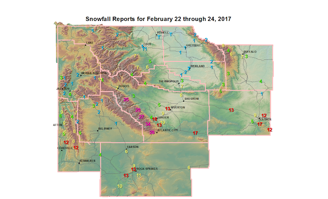
Final Snowfall Reports for latest Winter Storm

Public Information Statement...Updated
National Weather Service Riverton WY
145 PM MST Fri Feb 24 2017

...Final Snowfall Reports for latest Winter Storm...

The following snow reports are the final storm totals from the latest
Winter Storm and were collected from from 5 pm Wednesday evening
through noon Friday.

Note: SnoTELs (Snow Telemetry) are remote sensing sites in high
mountain watersheds. Snowfall data from SNOTELS are estimated based
on snow water equivalent.

Location                              Snowfall
Lincoln County... Hams Fork Snotel... 12 inches. Kelley Ranger Station Snotel... 12 inches. Willow Creek Snotel... 11 inches. Star Valley Ranch... 9 inches. 5 SSE Smoot... 8 inches. Indian Creek Snotel... 8 inches. Spring Creek Divide Snotel... 8 inches. 3 SE Bedford... 8 inches. Blind Bull Summit... 7 inches. Afton... 6 to 7 inches. Cottonwood Creek Snotel... 7 inches. Commissary Ridge... 6.5 inches. 2 SE Thayne... 5.7 inches. Salt River Summit Snotel... 5 inches. 3 S Fontenelle Dam... 4 inches. Box Y Ranch... 4 inches. Blind Bull Summit Snotel... 3 inches.Big Horn County...
Bald Mountain Snotel... 2 inches.
Bone Springs Divide Snotel... 2 inches.
9 NNW Shell... 1.3 inches.
7 W Basin... 1 inch.
Greybull... 1 inch.
9 ENE Greybull... 0.4 inches.Fremont County...
Townsend Creek Snotel... 34 inches.
St. Lawrence Alt Snotel... 28 inches.
Deer Park Snotel... 28 inches.
Hobbs Park Snotel... 27 inches.
South Pass Snotel... 26 inches.
Atlantic City... 26 inches.
Cold Springs Snotel... 25 inches.
9.5 SW Lander... 25 inches.
6 SW Lander... 23 inches.
6.6 SW Lander... 19 inches.
Jeffrey City... 17 inches.
Lander Airport... 16 inches.
Lander... 8 to 14 inches.
3 SW Lander... 14 inches.
9 SSE Lander... 14 inches.
Riverton Airport... 13 inches.
9 SSE Lander... 13 inches.
Riverton... 9 to 12 inches.
6 N Riverton... 11 inches.
2 W Riverton... 11 inches.
Little Warm Snotel... 11 inches.
2 W Riverton... 10 inches.
7 SE Lander... 9.8 inches.
Hudson... 9 inches.
Dubois... 7 inches.
Boysen Dam... 6 inches.
Jeffrey City... 6 inches.
Kinnear... 5 inches.
7 WNW Lander... 4.3 inches.
Brooks Lake... 4 inches.
Burris... 3 inches.Hot Springs County...
Thermopolis... 4 to 8 inches.
5 SE Thermopolis... 6.6 inches.
Owl Creek Snotel... 4 inches.
9 NE Thermopolis... 3 inches.
Kirby... 1 inch.Johnson County...
Little Goose Snotel... 8 inches.
Hansen Sawmill Snotel... 7 inches.
4 SSW Buffalo... 7 inches.
Soldier Park Snotel... 6 inches.
17 E Kaycee... 4 inches.
Buffalo... 3 to 4 inches.
Cloud Peak Reservoir Snotel... 4 inches.
Bear Trap Meadow Snotel... 3 inches.
3 ESE Buffalo... 2.5 inches.Natrona County...
Casper Mountain Snotel... 17 inches.
Powder River... 13 inches.
Reno Hill Snotel... 12 inches.
2 E Evansville... 12 inches.
Casper Mountain... 12 inches.
5 SSW Casper... 9.5 inches.
Casper Airport... 9.4 inches.
Casper... 4 to 8 inches.
1 S Casper... 7.2 inches.
3 WSW Casper... 5.4 inches.
10 WSW Casper... 5 inches.
Grave Spring Snotel... 5 inches.
4 WSW Casper... 3.1 inches.
4 SW Casper... 2 inches.
Midwest... 1 inch.Park County...
Timber Creek Snotel... 7 inches.
Marquette Snotel... 7 inches.
3 NE Sunshine... 6 inches.
1 NW Meeteetse... 5 inches.
Kirwin Snotel... 4 inches.
Wolverine Snotel... 2 inches.
2 WSW Cody... 2 inches.
Cody... 1 inch.
4 SE Cody... 1 inch.
4 SW Powell... 0.2 inches.Sublette County...
Snider Basin Snotel... 5 inches.
East Rim Divide Snotel... 3 inches.
Loomis Park Snotel... 2 inches.
Triple Peak Snotel... 2 inches.
14 NW Pinedale... 1.5 inches.
Kendall Ranger Station Snotel... 1 inch.
Boulder Rearing Station... 1 inch.Sweetwater County...
Rock Springs... 12 to 23 inches.
Green River... 12 to 19 inches.
4 NW Rock Springs... 11.5 inches.
7 SE Rock Springs... 11 inches.
Buckboard Marina... 10 inches.
Farson... 9 inches.
4 NNW Rock Springs... 8.5 inches.
Wamsutter... 6 to 8 inches.
Farson... 6 inches.Teton County...
Togwotee Pass Snotel... 11 inches.
Snow King... 4 inches.
Jackson... 3 inches.
Grand Targhee - Chief Joseph... 2.5 inches.
Jackson Hole - Mid Mountain... 2.2 inches.
Jackson Hole - Raymer... 2.1 inches.
Jackson Hole - Rendezvous Bowl... 2.1 inches.
Jackson Dam... 2 inches.
3 SSW Wilson... 2 inches.
Togwotee Mountain Lodge... 1.1 inches.
Jackson Hole - Base... 1 inch.
Granite Creek Snotel... 1 inch.
Grand Targhee Snotel... 1 inch.
Phillips Bench Snotel... 1 inch.
Moose... 1 inch.Washakie County...
Middle Powder Snotel... 3 inches.
5 NNW Ten Sleep... 2 inches.
Worland... 2 inches.
8 SW Worland... 1.5 inches.
Winchester... 1 inch.
Ten Sleep... 0.9 inches.
16 SSE Ten Sleep... 0.3 inches.Yellowstone National Park...
Yellowstone East Entrance... 1 inch.
Lamar Ranger Station... 1 inch.