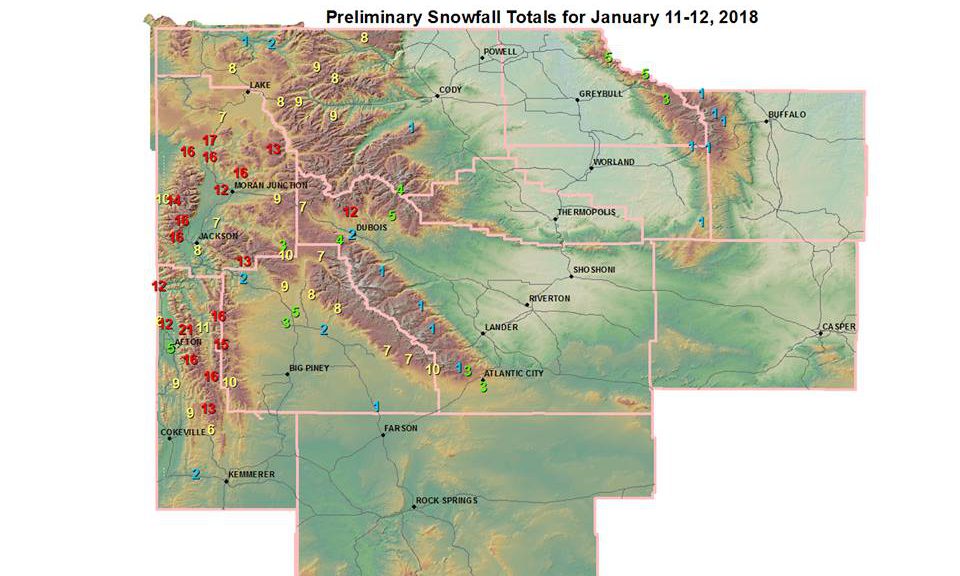
 Snow Reports January 11-12 2018
National Weather Service Riverton WY
615 PM MST Fri Jan 12 2018

...Preliminary Storm Information...

The following are preliminary snowfall reports since Thursday
morning, and peak wind gusts over the last 24 hours.  Most
Cooperative Observers and CocoRAHS observers report 24 hour snowfall
totals between 7 am and 9 am.

Observations are collected from a variety of sources with varying
equipment and exposures. We thank all volunteer weather observers
for their dedication. Not all data listed are considered official.

***** Snowfall Reports *****

Location                              Snowfall

Big Horn County...
 Bald Mountain Snotel...              5 inches.
 Bone Springs Divide Snotel...        5 inches.
 Shell Creek Snotel...                3 inches.
 Powder River Pass...                 1 inch.

Fremont County...
 Burroughs Creek Snotel...           12 inches.
 Brooks Lake...                       7 inches.
 Castle Creek Snotel...               5 inches.
 Little Warm Snotel...                4 inches.
 Atlantic City...                     3 inches.
 South Pass Snotel...                 3 inches.
 Dubois...                          1.5 inches.
 Cold Springs Snotel...               1 inch.
 Hobbs Park Snotel...                 1 inch.
 St. Lawrence Alt Snotel...           1 inch.
 Deer Park Snotel...                  1 inch.

Johnson County...
 Little Goose Snotel...               1 inch.
 Cloud Peak Reservoir Snotel...       1 inch.
 Soldier Park Snotel...               1 inch.
Lincoln County...
 Willow Creek Snotel...              21 inches.
 Cottonwood Creek Snotel...          16 inches.
 Blind Bull Summit Snotel...         16 inches.
 Spring Creek Divide Snotel...       16 inches.
 Commissary Ridge...                 15 inches.
 Blind Bull Summit...                13 inches.
 Indian Creek Snotel...              13 inches.
 Alpine...                           12 inches.
 2 SE Thayne...                    11.5 inches.
 Box Y Ranch...                      11 inches.
 5 NNE Thayne...                     11 inches.
 3 SE Bedford...                     11 inches.
 Star Valley Ranch...               9.5 inches.
 5 SSE Smoot...                       9 inches.
 Kelley Ranger Station Snotel...      9 inches.
 Salt River Summit Snotel...          9 inches.
 Thayne...                            6 inches.
 Hams Fork Snotel...                  6 inches.
 Afton...                           4.6 inches.
 Fossil Butte...                    1.5 inches.

Park County...
 Wolverine Snotel...                 10 inches.
 Blackwater Snotel...                 9 inches.
 Beartooth Lake Snotel...             8 inches.
 Pahaska...                           8 inches.
 Evening Star Snotel...               8 inches.
 Kirwin Snotel...                     4 inches.
 Marquette Snotel...                  1 inch.
 26 SW Cody...                      0.3 inches.

Sublette County...
 Triple Peak Snotel...               15 inches.
 East Rim Divide Snotel...           10 inches.
 Snider Basin Snotel...              10 inches.
 Larsen Creek Snotel...              10 inches.
 Kendall Ranger Station Snotel...    10 inches.
 Loomis Park Snotel...                9 inches.
 New Fork Lake Snotel...              8 inches.
 Elkhart Park G.S. Snotel...          8 inches.
 Big Sandy Opening Snotel...          7 inches.
 Gunsite Pass Snotel...               7 inches.
 Pocket Creek Snotel...               7 inches.
 14 NW Pinedale...                    5 inches.
 Daniel Fish Hatchery...            3.3 inches.
 Bondurant...                       2.3 inches.
 Pinedale...                          2 inches.
 14 N Farson...                       1 inch.

Sweetwater County...
 2 NNE Farson...                    0.2 inches.
 7 SE Rock Springs...               0.2 inches.

Teton County...
 Jackson Hole - Rendezvous Bowl... 16.1 inches.
 Grassy Lake Snotel...               16 inches.
 Jackson Hole - Mid Mountain...      16 inches.
 Snake River Stn Snotel...           16 inches.
 Phillips Bench Snotel...            16 inches.
 Base Camp Snotel...                 16 inches.
 Grand Targhee Snotel...             14 inches.
 Jackson Hole - Raymer...            14 inches.
 5 NW Jackson...                   13.5 inches.
 Granite Creek Snotel...             13 inches.
 Jackson Dam...                    12.1 inches.
 3 SSW Wilson...                     12 inches.
 Togwotee Pass Snotel...             11 inches.
 2 NE Teton Village...               10 inches.
 Grand Targhee - Chief Joseph...     10 inches.
 Gros Ventre Summit Snotel...        10 inches.
 Togwotee Mountain Lodge...           9 inches.
 Snow King...                         8 inches.
 Jackson...                           8 inches.
 12 NE Jackson...                     7 inches.
 Jackson...                           7 inches.
 Jackson Hole - Base...               5 inches.
 Darwin Ranch...                    3.3 inches.

Washakie County...
 Powder River Pass Snotel...          1 inch.
 Middle Powder Snotel...              1 inch.

Yellowstone National Park...
 Lewis Lake Divide Snotel...         17 inches.
 Two Ocean Plateau Snotel...         13 inches.
 Sylvan Road Snotel...                9 inches.
 Parker Peak Snotel...                9 inches.
 Canyon Snotel...                     8 inches.
 Sylvan Lake Snotel...                8 inches.
 Thumb Divide Snotel...               7 inches.
 Lamar Ranger Station...              2 inches.
 Tower Falls Ranger Station...        1 inch.