National Weather Service Pocatello ID
1101 AM MST Fri Mar 2 2018
South Central Highlands-Caribou Highlands-
Cache Valley/Idaho Portion-Wasatch Mountains/Idaho Portion-
Including the cities of Henry, Soda Springs, Preston,
and Montpelier
1101 AM MST Fri Mar 2 2018
...WINTER STORM WARNING REMAINS IN EFFECT UNTIL 11 AM MST
SUNDAY...
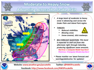
* WHAT...Heavy snow and blowing snow expected. Plan on difficult
travel conditions, including during the evening commute. Total
snow accumulations of 8 to 12 inches, with localized amounts
up to 31 inches, are expected.
* WHERE...I 84 from milepost 228 to the Utah border, I 15 from
the milepost 63 to the Utah Border, U.S. Highways 26, 30, 89
and 91, and state highways 34 and 36.
* WHEN...Until 11 AM MST Sunday.
* ADDITIONAL DETAILS...Winds gusting as high as 40 mph will
cause areas of blowing and drifting snow, especially over
mountain passes.
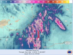
Total forecast snowfall until Noon Sunday March 4 2018
Jackson Hole-Star Valley-
Including the cities of Jackson, Afton, Alpine,
Star Valley Ranch, and Thayne
246 PM MST Fri Mar 2 2018

...WINTER WEATHER ADVISORY REMAINS IN EFFECT UNTIL 11 PM MST THIS
EVENING...

* WHAT...Snow. Additional snow accumulations of 1 to 3 inches
  are expected.

* WHERE...Jackson Hole and Star Valley.

* WHEN...Until 11 PM MST this evening.

* ADDITIONAL DETAILS...Plan on slippery road conditions,
  including during the evening commute. Be prepared for reduced
  visibilities at times.