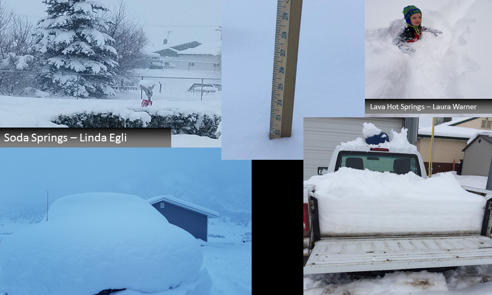
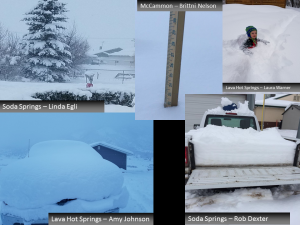
Final Weekend Snow Totals including Very Large Amounts in Southeast Idaho
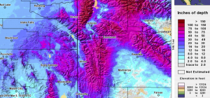
Final amounts have now been posted for the weekend snowstorm over Western Wyoming and Southeast Idaho. Very impressive snow amounts were reported south and east of Pocatello and Idaho Falls. One of the greatest totals outside of higher mountains was the 30 inches near Lava Hot Springs with several observations near or above 20 inches in southeastern Idaho. Following is a plot of the 72 hour snowfall across this area.
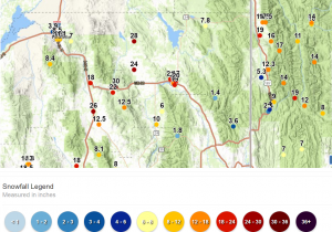
The final totals posted by Riverton Forecast Office follows. Note that reports in the Grand Targhee area were 4-5 feet.
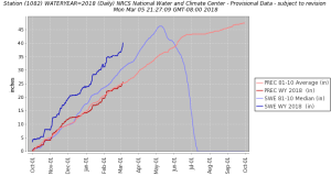
National Weather Service Riverton WY
216 PM MST Mon Mar 5 2018

The following are the final snowfall totals for the latest winter
storm system that were recorded between Midnight Friday morning and
Noon Monday.

Observations are collected from a variety of sources with varying
equipment and exposures. We thank all volunteer weather observers
for their dedication. Not all data listed are considered official.

Note: SnoTELS (Snow Telemetry) are remote sensing sites in high
mountain watersheds. Snowfall data from SNOTELS are estimated based
on snow water equivalent.

Location                              Snowfall

Big Horn County...
 9 NNW Shell...                     7.2 inches.
 Bald Mountain Snotel...              6 inches.
 Bone Springs Divide Snotel...        6 inches.
 Shell Creek Snotel...                4 inches.
 9 ENE Greybull...                  3.3 inches.
 2 SSW Lovell...                      3 inches.
 Greybull...                          2 inches.
 Lovell...                          1.5 inches.
 1 W Lovell...                        1 inch.
 7 W Basin...                         1 inch.

Fremont County...
 Brooks Lake...                      19 inches.
 Cold Springs Snotel...               7 inches.
 Little Warm Snotel...                5 inches.
 Burroughs Creek Snotel...            5 inches.
 Dubois...                          3.5 inches.
 Castle Creek Snotel...               3 inches.
 Hobbs Park Snotel...                 3 inches.
 Deer Park Snotel...                  2 inches.
 Atlantic City...                     2 inches.
 South Pass Snotel...                 1 inch.
 Townsend Creek Snotel...             1 inch.
 Burris...                            1 inch.
 Riverton Airport...                0.3 inches.
 7 WNW Lander...                    0.1 inches.

Hot Springs County...
 9 NE Thermopolis...                2.1 inches.
 Thermopolis...                       2 inches.
 Owl Creek Snotel...                  1 inch.

Johnson County...
 Bear Trap Meadow Snotel...           2 inches.
 Little Goose Snotel...               1 inch.
 Hansen Sawmill Snotel...             1 inch.
 19 NNW Kaycee...                   0.5 inches.

Lincoln County...
 Commissary Ridge...                 19 inches.
 2 SE Thayne...                      19 inches.
 5 NNE Thayne...                   17.5 inches.
 Willow Creek Snotel...              17 inches.
 3 SE Bedford...                     16 inches.
 Star Valley Ranch...              14.5 inches.
 Cottonwood Creek Snotel...          14 inches.
 Blind Bull Summit...                14 inches.
 Afton...                          12.3 inches.
 Spring Creek Divide Snotel...       12 inches.
 Box Y Ranch...                      11 inches.
 Blind Bull Summit Snotel...         10 inches.
 5 SSE Smoot...                       9 inches.
 Hams Fork Snotel...                  8 inches.
 Indian Creek Snotel...               7 inches.
 Kelley Ranger Station Snotel...      7 inches.
 Fairview...                        5.3 inches.
 Salt River Summit Snotel...          4 inches.
 Fossil Butte...                    2.5 inches.

Natrona County...
 Reno Hill Snotel...                  2 inches.
 Grave Springs Snotel...              1 inch.

Park County...
 Blackwater Snotel...                13 inches.
 Pahaska...                          13 inches.
 Evening Star Snotel...               9 inches.
 Kirwin Snotel...                     8 inches.
 Beartooth Lake Snotel...             7 inches.
 Marquette Snotel...                  7 inches.
 26 SW Cody...                      6.5 inches.
 Wolverine Snotel...                  6 inches.
 2 WSW Cody...                        3 inches.
 Timber Creek Snotel...               3 inches.
 3 NE Sunshine...                     2 inches.
 3 NE Clark...                        2 inches.
 Cody...                            1.5 inches.

Sublette County...
 Triple Peak Snotel...               14 inches.
 Gunsite Pass Snotel...               9 inches.
 Snider Basin Snotel...               8 inches.
 Bondurant...                       6.1 inches.
 Elkhart Park G.S. Snotel...          6 inches.
 East Rim Divide Snotel...            5 inches.
 Loomis Park Snotel...                4 inches.
 Larsen Creek Snotel...               4 inches.
 Kendall Ranger Station Snotel...     3 inches.
 Big Sandy Opening Snotel...          3 inches.
 14 NW Pinedale...                  1.6 inches.
 Pinedale...                        1.6 inches.
 Daniel Fish Hatchery...              1 inch.
 New Fork Lake Snotel...              1 inch.
 Boulder Rearing Station...           1 inch.

Sweetwater County...
 Rock Springs...                    1.6 inches.
 7 SE Rock Springs...               1.6 inches.
 2 NNE Farson...                    1.2 inches.
 Green River...                       1 inch.
 4 NNW Rock Springs...              0.3 inches.

Teton County...
 Grand Targhee - Chief Joseph...     57 inches.
 Grand Targhee Snotel...             41 inches.
 Jackson Hole - Rendezvous Bowl...   29 inches.
 Jackson Hole - Raymer...            27 inches.
 Togwotee Mountain Lodge...          24 inches.
 1 NNW Alta...                       23 inches.
 Togwotee Pass Snotel...             23 inches.
 Jackson Hole - Mid Mountain...      23 inches.
 Phillips Bench Snotel...            19 inches.
 Grassy Lake Snotel...               19 inches.
 Jackson Dam...                    13.2 inches.
 Jackson Hole - Base...              13 inches.
 Gros Ventre Summit Snotel...        12 inches.
 Base Camp Snotel...                 12 inches.
 1 ENE Teton Village...              11 inches.
 12 NE Jackson...                    11 inches.
 Snow King...                        11 inches.
 2 SW Wilson...                    10.5 inches.
 Jackson...                        10.2 inches.
 Snake River Stn Snotel...           10 inches.
 2 NE Teton Village...               10 inches.
 Moose...                             8 inches.
 Darwin Ranch...                      8 inches.
 Granite Creek Snotel...              7 inches.

Washakie County...
 Ten Sleep...                       5.2 inches.
 5 NNW Ten Sleep...                 5.2 inches.
 Middle Powder Snotel...              5 inches.
 16 SSE Ten Sleep...                3.5 inches.
 Powder River Pass Snotel...          3 inches.
 27 S Ten Sleep...                    3 inches.
 Winchester...                        1 inch.
 8 SW Worland...                      1 inch.

Yellowstone National Park...
 Two Ocean Plateau Snotel...         15 inches.
 Lewis Lake Divide Snotel...         14 inches.
 Sylvan Road Snotel...               14 inches.
 Sylvan Lake Snotel...               13 inches.
 Thumb Divide Snotel...              12 inches.
 Parker Peak Snotel...               10 inches.
 Lamar Ranger Station...            8.4 inches.
 Canyon Snotel...                     7 inches.
Tower Falls Ranger Station...      5.8 inches.

Interesting to see the SNOTEL graph at Targhee where the water content is well above normal.
The next image is of the current snow depth over Southeast Idaho and Western Wyoming