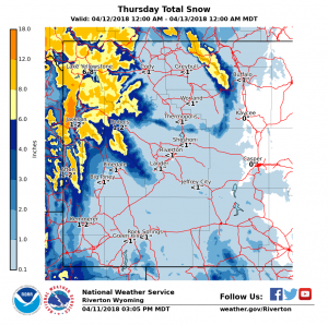
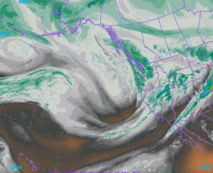
Forecast Snowfall Thursday April 12 2018Water Vapor Imagery Wednesday Afternoon April 11 2018
National Weather Service Riverton WY
224 PM MDT Wed Apr 11 2018

...Winter Returns Once Again to Western and Northern Wyoming
Later tonight, Continuing Into Friday...

.A strong, relatively wet and windy Pacific storm will bring
strong winds and moderate to heavy snow at times to western
wyoming starting later tonight. The snow and wind may spread
across northern Wyoming Thursday afternoon in the Bighorn
mountains then spread into the lower elevations of the north
Thursday evening, tapering off in the western mountains early
Friday morning. The snow and wind will end across the north
Friday afternoon.


Jackson Hole-Star Valley-
Including the cities of Jackson, Afton, Alpine,
Star Valley Ranch, and Thayne
224 PM MDT Wed Apr 11 2018

...WINTER WEATHER ADVISORY REMAINS IN EFFECT FROM 9 PM THURSDAY
TO 6 AM MDT FRIDAY...

* WHAT...Snow expected. Total snow accumulations of 2 to 4
  inches are expected.

* WHERE...Jackson Hole and Star Valley.

* WHEN...From 9 PM Thursday to 6 AM MDT Friday.

* ADDITIONAL DETAILS...Plan on slippery road conditions. Expect
  reduced visibilities at times.

PRECAUTIONARY/PREPAREDNESS ACTIONS...

A Winter Weather Advisory for snow means periods of snow will
cause primarily travel difficulties. Expect snow covered roads
and limited visibilities, and use caution while driving. The
latest road conditions for the state you are calling from can be
obtained by calling 5 1 1.