 Public Information Statement
National Weather Service Riverton WY
618 AM MDT Sun Jun 17 2018
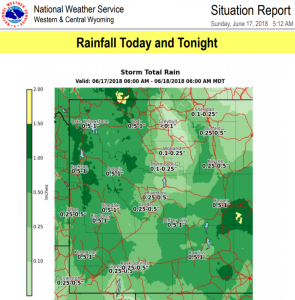
...Here are Rainfall Totals so far through 600 AM MDT Sunday
morning...
Location Amount Elevation (ft.)
...Yellowstone National Park...
Extreme Sw Yellowstone 1.33 in 6400
Lake Village 1.31 in 7875
4 W South Entrance YNP 1.13 in 7040
Lake Yellowstone 1.11 in 7835
14 S Sylvan Pass 1.11 in 8650
Hoyt Peak 0.97 in 9800
South Entrance YNP 0.86 in 6900
1 SW Canyon 0.75 in 7900
9 E Tower Junction 0.58 in 7266
Mammoth 0.47 in 6300
Gardner River Nr Mammoth, Ye 0.32 in 5624
Tower Falls 0.31 in 6266
15 WSW Mammoth 0.28 in 7900
...Wind River Mountains West...
19 WSW Dubois 0.12 in 8833
8 W South Pass City 0.01 in 8120
...Wind River Mountains East...
9 SW Lander 0.34 in 7085
10 W Fort Washakie 0.21 in 9235
10 W Dubois 0.09 in 8432
...Wind River Basin...
3 NNW Hudson 0.35 in 5555
Riverton Airport 0.23 in 5525
N. Fork Little Wind River 0.19 in 6120
Riverton Forecast Office 0.19 in 5576
Fort Washakie 0.15 in 5565
10 SE Crowheart 0.10 in 5654
Boysen Reservoir 0.03 in 4710
...Upper Wind River Basin...
Crowheart 0.14 in 6099
11 W Crowheart 0.08 in 6520
6 NW Dubois 0.06 in 7189
...Upper Green River Basin...
Big Piney Airport 0.39 in 6974
9 E Big Piney 0.09 in 6803
...Upper Green River Basin Foothills...
Bondurant 0.23 in 6650
2 NW Bondurant 0.20 in 6726
Pinedale 0.04 in 7310
...Teton and Gros Ventre Mountains...
17 N Alta 1.08 in 6830
Alta 0.55 in 6430
Darwin Ranch - Coop 0.16 in 8160
...Star Valley...
Afton 0.14 in 6267
1 NW Afton 0.10 in 6211
3 NW Etna 0.10 in 5692
3 NW Etna 0.10 in 5676
1 S Bedford 0.07 in 6279
Thayne 0.01 in 5928
...Southwest Big Horn Basin...
Kirby 0.06 in 4350
Thermopolis 0.04 in 4426
...Southeast Johnson County...
3 SSE Barnum 1.60 in 5075
17 E Kaycee 0.44 in 4362
2 NW Mayoworth 0.37 in 5404
Linch 0.12 in 4934
Kaycee 0.03 in 4681
...Southeast Big Horn Basin...
Worland 0.20 in 4042
Worland Airport 0.09 in 4245
1 NNE Worland 0.08 in 4065
10 SSE Worland 0.04 in 4520
...South Lincoln County...
Cokeville 0.10 in 6191
Kemmerer 0.01 in 6980
...Salt River and Wyoming Ranges...
9 W Calpet 0.53 in 8693
21 W Big Piney 0.33 in 8200
15 NE Cokeville 0.23 in 8470
13 E Cokeville 0.08 in 7460
Smiths Fork Near Border 0.06 in 6650
...Rock Springs and Green River...
12 W Green River 0.01 in 6130
...Owl Creek and Bridger Mountains...
13 NW Lost Cabin 0.21 in 6110
10 S Meeteetse 0.07 in 7127
S. Fork Owl Creek Below Anch 0.06 in 6120
...Northeast Johnson County...
Buffalo Airport 0.28 in 4970
7 NE Buffalo 0.25 in 4370
13 SSE Buffalo 0.20 in 4819
8 S Story 0.17 in 5279
...North Big Horn Basin...
Powell 0.51 in 4386
2 N Frannie 0.43 in 4275
Lovell 0.22 in 3830
11 ESE Lovell 0.20 in 3660
Greybull Airport 0.19 in 3935
Basin 0.04 in 3897
Basin 0.03 in 3821
...Natrona County Lower Elevations...
1 E Casper 0.36 in 5334
Casper - N Platte River 0.32 in 5100
Mills 0.31 in 5150
Midwest 0.29 in 4865
3 WSW Mills 0.28 in 5197
Casper Airport 0.21 in 5320
Bar Nunn 0.17 in 5275
8 SE Evansville 0.15 in 5592
...Lander Foothills...
N Fork Popo Agie River 0.55 in 5760
7 NW Lander 0.48 in 5797
Middle Fork Popo Agie River 0.42 in 6555
Lander Airport 0.11 in 5586
11 SSE Lander 0.09 in 5773
...Jackson Hole...
5 S Of South Entrance Ynp 0.75 in 7020
7 E Moran Jct 0.43 in 7251
Snake River At Jackson Lake 0.36 in 6779
Moose 0.29 in 6466
Kelly 0.27 in 6653
4 N Moose 0.26 in 6730
2 NE Wilson 0.21 in 6184
Jackson 0.18 in 6240
Jackson Hole Airport 0.17 in 6445
3 SSW Jackson 0.12 in 6158
Hoback Junction 0.09 in 5928
...Green Mountains and Rattlesnake Range...
7 SW Muddy Gap 0.76 in 7380
16 S Hiland 0.47 in 6380
Independence Rock 0.28 in 5920
Pathfinder Reservoir 0.23 in 5858
...Cody Foothills...
5 WNW Clark 0.77 in 4659
Cody Airport 0.71 in 5100
2 WSW Cody 0.67 in 5167
1 W Clark 0.62 in 4270
Meeteetse 0.47 in 5797
20 SW Cody 0.45 in 5843
2 W Pitchfork 0.35 in 6883
Buffalo Bill Reservoir 0.28 in 5357
...Casper Mountain...
8 S Casper 0.40 in 7740
13 S Casper 0.34 in 6830
...Bighorn Mountains West...
15 SSW Big Trails 0.32 in 6554
30 E Greybull 0.20 in 8898
5 ENE Hyattville 0.18 in 5670
12 ENE Ten Sleep 0.03 in 8202
...Bighorn Mountains Southeast...
16 SE Big Trails 0.67 in 7220
20 NW Mayoworth 0.44 in 8180
7 NW Mayoworth 0.27 in 5720
18 WNW Buffalo 0.18 in 8580
18 NW Buffalo 0.17 in 8604
14 W Buffalo 0.08 in 8400
7 WSW Buffalo 0.08 in 5745
...Absaroka Mountains...
3 E Pahaska 1.51 in 7500
10 WNW Cody 1.30 in 8401
Crandall 1.17 in 6640
Pahaska 1.05 in 6800
NE Entrance Yellowstone 0.99 in 7360
6 E Sunlight Basin 0.85 in 6228
19 SSW Wapiti 0.57 in 6200
10 N Dubois 0.20 in 8085
14 ENE Dubois 0.17 in 7365
Observations are collected from a variety of sources with varying
equipment and exposures. We thank all volunteer weather observers
for their dedication. Not all data listed are considered official.
Public Information Statement
National Weather Service Riverton WY
618 AM MDT Sun Jun 17 2018

...Here are Rainfall Totals so far through 600 AM MDT Sunday
   morning...

Location                     Amount     Elevation (ft.)

...Yellowstone National Park...
Extreme Sw Yellowstone       1.33 in    6400
Lake Village                 1.31 in    7875
4 W South Entrance YNP       1.13 in    7040
Lake Yellowstone             1.11 in    7835
14 S Sylvan Pass             1.11 in    8650
Hoyt Peak                    0.97 in    9800
South Entrance YNP           0.86 in    6900
1 SW Canyon                  0.75 in    7900
9 E Tower Junction           0.58 in    7266
Mammoth                      0.47 in    6300
Gardner River Nr Mammoth, Ye 0.32 in    5624
Tower Falls                  0.31 in    6266
15 WSW Mammoth               0.28 in    7900

...Wind River Mountains West...
19 WSW Dubois                0.12 in    8833
8 W South Pass City          0.01 in    8120

...Wind River Mountains East...
9 SW Lander                  0.34 in    7085
10 W Fort Washakie           0.21 in    9235
10 W Dubois                  0.09 in    8432

...Wind River Basin...
3 NNW Hudson                 0.35 in    5555
Riverton Airport             0.23 in    5525
N. Fork Little Wind River    0.19 in    6120
Riverton Forecast Office     0.19 in    5576
Fort Washakie                0.15 in    5565
10 SE Crowheart              0.10 in    5654
Boysen Reservoir             0.03 in    4710

...Upper Wind River Basin...
Crowheart                    0.14 in    6099
11 W Crowheart               0.08 in    6520
6 NW Dubois                  0.06 in    7189

...Upper Green River Basin...
Big Piney Airport            0.39 in    6974
9 E Big Piney                0.09 in    6803

...Upper Green River Basin Foothills...
Bondurant                    0.23 in    6650
2 NW Bondurant               0.20 in    6726
Pinedale                     0.04 in    7310

...Teton and Gros Ventre Mountains...
17 N Alta                    1.08 in    6830
Alta                         0.55 in    6430
Darwin Ranch - Coop          0.16 in    8160

...Star Valley...
Afton                        0.14 in    6267
1 NW Afton                   0.10 in    6211
3 NW Etna                    0.10 in    5692
3 NW Etna                    0.10 in    5676
1 S Bedford                  0.07 in    6279
Thayne                       0.01 in    5928

...Southwest Big Horn Basin...
Kirby                        0.06 in    4350
Thermopolis                  0.04 in    4426

...Southeast Johnson County...
3 SSE Barnum                 1.60 in    5075
17 E Kaycee                  0.44 in    4362
2 NW Mayoworth               0.37 in    5404
Linch                        0.12 in    4934
Kaycee                       0.03 in    4681

...Southeast Big Horn Basin...
Worland                      0.20 in    4042
Worland Airport              0.09 in    4245
1 NNE Worland                0.08 in    4065
10 SSE Worland               0.04 in    4520

...South Lincoln County...
Cokeville                    0.10 in    6191
Kemmerer                     0.01 in    6980

...Salt River and Wyoming Ranges...
9 W Calpet                   0.53 in    8693
21 W Big Piney               0.33 in    8200
15 NE Cokeville              0.23 in    8470
13 E Cokeville               0.08 in    7460
Smiths Fork Near Border      0.06 in    6650

...Rock Springs and Green River...
12 W Green River             0.01 in    6130

...Owl Creek and Bridger Mountains...
13 NW Lost Cabin             0.21 in    6110
10 S Meeteetse               0.07 in    7127
S. Fork Owl Creek Below Anch 0.06 in    6120

...Northeast Johnson County...
Buffalo Airport              0.28 in    4970
7 NE Buffalo                 0.25 in    4370
13 SSE Buffalo               0.20 in    4819
8 S Story                    0.17 in    5279

...North Big Horn Basin...
Powell                       0.51 in    4386
2 N Frannie                  0.43 in    4275
Lovell                       0.22 in    3830
11 ESE Lovell                0.20 in    3660
Greybull Airport             0.19 in    3935
Basin                        0.04 in    3897
Basin                        0.03 in    3821

...Natrona County Lower Elevations...
1 E Casper                   0.36 in    5334
Casper - N Platte River      0.32 in    5100
Mills                        0.31 in    5150
Midwest                      0.29 in    4865
3 WSW Mills                  0.28 in    5197
Casper Airport               0.21 in    5320
Bar Nunn                     0.17 in    5275
8 SE Evansville              0.15 in    5592

...Lander Foothills...
N Fork Popo Agie River       0.55 in    5760
7 NW Lander                  0.48 in    5797
Middle Fork Popo Agie River  0.42 in    6555
Lander Airport               0.11 in    5586
11 SSE Lander                0.09 in    5773

...Jackson Hole...
5 S Of South Entrance Ynp    0.75 in    7020
7 E Moran Jct                0.43 in    7251
Snake River At Jackson Lake  0.36 in    6779
Moose                        0.29 in    6466
Kelly                        0.27 in    6653
4 N Moose                    0.26 in    6730
2 NE Wilson                  0.21 in    6184
Jackson                      0.18 in    6240
Jackson Hole Airport         0.17 in    6445
3 SSW Jackson                0.12 in    6158
Hoback Junction              0.09 in    5928

...Green Mountains and Rattlesnake Range...
7 SW Muddy Gap               0.76 in    7380
16 S Hiland                  0.47 in    6380
Independence Rock            0.28 in    5920
Pathfinder Reservoir         0.23 in    5858

...Cody Foothills...
5 WNW Clark                  0.77 in    4659
Cody Airport                 0.71 in    5100
2 WSW Cody                   0.67 in    5167
1 W Clark                    0.62 in    4270
Meeteetse                    0.47 in    5797
20 SW Cody                   0.45 in    5843
2 W Pitchfork                0.35 in    6883
Buffalo Bill Reservoir       0.28 in    5357

...Casper Mountain...
8 S Casper                   0.40 in    7740
13 S Casper                  0.34 in    6830

...Bighorn Mountains West...
15 SSW Big Trails            0.32 in    6554
30 E Greybull                0.20 in    8898
5 ENE Hyattville             0.18 in    5670
12 ENE Ten Sleep             0.03 in    8202

...Bighorn Mountains Southeast...
16 SE Big Trails             0.67 in    7220
20 NW Mayoworth              0.44 in    8180
7 NW Mayoworth               0.27 in    5720
18 WNW Buffalo               0.18 in    8580
18 NW Buffalo                0.17 in    8604
14 W Buffalo                 0.08 in    8400
7 WSW Buffalo                0.08 in    5745

...Absaroka Mountains...
3 E Pahaska                  1.51 in    7500
10 WNW Cody                  1.30 in    8401
Crandall                     1.17 in    6640
Pahaska                      1.05 in    6800
NE Entrance Yellowstone      0.99 in    7360
6 E Sunlight Basin           0.85 in    6228
19 SSW Wapiti                0.57 in    6200
10 N Dubois                  0.20 in    8085
14 ENE Dubois                0.17 in    7365

Observations are collected from a variety of sources with varying
equipment and exposures. We thank all volunteer weather observers
for their dedication. Not all data listed are considered official.