
Winter Storm Watch Star Valley Late Saturday Night Through Monday Morning
Winter Storm Watch
A strong polar jet will move from the northeast Pacific Ocean to across the interior west by later this weekend.
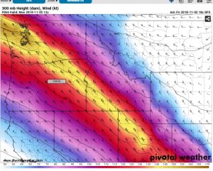
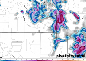
Widespread snows will develop along and to the northern side of the jet Sunday into Monday morning. Following is the model forecast for weekend snowfall totals through Monday morning November 5 2018
This pattern brings the first possible significant snowfall across the mountains as well as Star Valley later this weekend. Therefore the Riverton National Weather Service Forecast Office has issued a Winter Storm Watch
...WINTER STORM WATCH IN EFFECT FROM LATE SATURDAY NIGHT THROUGH
LATE SUNDAY NIGHT...
Star Valley-
Including the cities of Afton, Alpine, Star Valley Ranch,
and Thayne


* WHAT...Heavy snow possible. Total snow accumulations of 4 to 6
  inches possible with locally higher amounts near the foothills
  on the east side of the valley. There is still some uncertainty
  on temperatures and whether there could be some rain snow mix
  during the day Sunday. Stay tuned on this potential significant
  snow event.

* WHERE...Star Valley.

* WHEN...From late Saturday night through late Sunday night.

* ADDITIONAL DETAILS...Travel could be very difficult.

PRECAUTIONARY/PREPAREDNESS ACTIONS...

A Winter Storm Watch means there is potential for significant
snow, sleet or ice accumulations that may impact travel. Continue
to monitor the latest forecasts.