 Public Information Statement
National Weather Service Riverton WY
1238 PM MST Thu Jan 24 2019
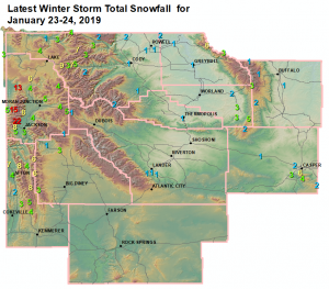
The following are the final snowfall totals for the latest winter
storm. The following amounts are from midnight Wednesday January
23rd to 10 am Thursday January 24th.
Observations are collected from a variety of sources with varying
equipment and exposures. We thank all volunteer weather observers
for their dedication. Not all data listed are considered official.
Note: SnoTELS (Snow Telemetry) are remote sensing sites in high
mountain watersheds. Snowfall data from SNOTELS are estimated based
on snow water equivalent.
***** Snowfall Total Reports *****
Location Snowfall
Big Horn County...
Bald Mountain Snotel... 6 inches.
Bone Springs Divide Snotel... 3 inches.
Deaver... 1.5 inches.
9 ENE Greybull... 1.2 inches.
Greybull... 0.8 inches.
Lovell... 0.5 inches.
Fremont County...
Lander Airport... 1.1 inches.
6 SW Lander... 1 inch.
9 SSE Lander... 1 inch.
1 N Lander... 1 inch.
Lander... 1 inch.
Brooks Lake... 1 inch.
7 SE Lander... 0.8 inches.
9 SSE Lander... 0.7 inches.
Riverton Airport... 0.4 inches.
2 W Riverton... 0.3 inches.
Hot Springs County...
Thermopolis... 1 inch.
Lucerne... 1 inch.
9 NE Thermopolis... 0.4 inches.
Johnson County...
Bear Trap Meadow Snotel... 2 inches.
13 SSE Buffalo... 1 inch.
Cloud Peak Reservoir Snotel... 1 inch.
Little Goose Snotel... 1 inch.
Soldier Park Snotel... 1 inch.
Lincoln County...
Spring Creek Divide Snotel... 8 inches.
Star Valley Ranch... 8 inches.
Willow Creek Snotel... 8 inches.
2 SE Thayne... 7.2 inches.
Commissary Ridge... 7 inches.
Blind Bull Summit... 6 inches.
Blind Bull Summit Snotel... 6 inches.
Cottonwood Creek Snotel... 6 inches.
Indian Creek Snotel... 5 inches.
Box Y Ranch... 4 inches.
Hams Fork Snotel... 4 inches.
5 SSE Smoot... 4 inches.
Afton... 3.6 inches.
Kelley Ranger Station Snotel... 3 inches.
Salt River Summit Snotel... 2 inches.
Natrona County...
5 SSW Casper... 6 inches.
Casper... 2 to 4 inches.
Casper Mountain Snotel... 4 inches.
1 S Casper... 3.6 inches.
10 WSW Casper... 3 inches.
4 WSW Casper... 2.4 inches.
Reno Hill Snotel... 2 inches.
Grave Springs Snotel... 2 inches.
1 SW Casper... 1.75 inches.
Casper Airport... 1.7 inches.
Powder River... 1 inch.
Park County...
Pahaska... 5 inches.
Wolverine Snotel... 3 inches.
Evening Star Snotel... 3 inches.
3 NE Clark... 2 inches.
Kirwin Snotel... 2 inches.
Blackwater Snotel... 2 inches.
Beartooth Lake Snotel... 2 inches.
4 SW Powell... 1 inch.
2 WSW Cody... 1 inch.
4 ENE Powell... 0.5 inches.
3 NE Sunshine... 0.5 inches.
Sublette County...
Triple Peak Snotel... 6 inches.
East Rim Divide Snotel... 3 inches.
Snider Basin Snotel... 3 inches.
Bondurant... 1.3 inches.
14 NW Pinedale... 0.3 inches.
Teton County...
Jackson Hole - Rendezvous Bowl... 22 inches.
Grand Targhee - Chief Joseph... 21 inches.
Jackson Hole - Raymer... 20 inches.
Jackson Hole - Mid Mountain... 17 inches.
Grand Targhee Snotel... 15 inches.
Grassy Lake Snotel... 13 inches.
2 NE Teton Village... 10 inches.
Grand Targhee Ski Area... 10 inches.
5 NW Jackson... 8 inches.
Phillips Bench Snotel... 8 inches.
6 NW Moose... 8 inches.
Jackson Hole - Base... 6 inches.
3 SSW Wilson... 5 inches.
Togwotee Pass Snotel... 5 inches.
1 NNW Alta... 5 inches.
Base Camp Snotel... 5 inches.
12 NE Jackson... 4 inches.
Togwotee Mountain Lodge... 4 inches.
Snake River Stn Snotel... 4 inches.
Snow King... 3 inches.
Gros Ventre Summit Snotel... 1 inch.
Washakie County...
Middle Powder Snotel... 5 inches.
27 S Ten Sleep... 3.1 inches.
Powder River Pass Snotel... 3 inches.
16 SSE Ten Sleep... 2.5 inches.
Ten Sleep... 1.8 inches.
5 NNW Ten Sleep... 1.1 inches.
Yellowstone National Park...
Sylvan Lake Snotel... 9 inches.
Parker Peak Snotel... 7 inches.
Yellowstone East Entrance... 7 inches.
Lewis Lake Divide Snotel... 6 inches.
Canyon Snotel... 4 inches.
Two Ocean Plateau Snotel... 4 inches.
Lamar Ranger Station... 3.1 inches.
Sylvan Road Snotel... 3 inches.
Snake River Ranger Station... 2.4 inches.
Tower Falls Ranger Station... 1 inch.
Public Information Statement
National Weather Service Riverton WY
1238 PM MST Thu Jan 24 2019

The following are the final snowfall totals for the latest winter
storm. The following amounts are from midnight Wednesday January
23rd to 10 am Thursday January 24th.

Observations are collected from a variety of sources with varying
equipment and exposures. We thank all volunteer weather observers
for their dedication. Not all data listed are considered official.

Note: SnoTELS (Snow Telemetry) are remote sensing sites in high
mountain watersheds. Snowfall data from SNOTELS are estimated based
on snow water equivalent.

*****  Snowfall Total Reports  *****

Location                              Snowfall

Big Horn County...
 Bald Mountain Snotel...              6 inches.
 Bone Springs Divide Snotel...        3 inches.
 Deaver...                          1.5 inches.
 9 ENE Greybull...                  1.2 inches.
 Greybull...                        0.8 inches.
 Lovell...                          0.5 inches.

Fremont County...
 Lander Airport...                  1.1 inches.
 6 SW Lander...                       1 inch.
 9 SSE Lander...                      1 inch.
 1 N Lander...                        1 inch.
 Lander...                            1 inch.
 Brooks Lake...                       1 inch.
 7 SE Lander...                     0.8 inches.
 9 SSE Lander...                    0.7 inches.
 Riverton Airport...                0.4 inches.
 2 W Riverton...                    0.3 inches.

Hot Springs County...
 Thermopolis...                       1 inch.
 Lucerne...                           1 inch.
 9 NE Thermopolis...                0.4 inches.

Johnson County...
 Bear Trap Meadow Snotel...           2 inches.
 13 SSE Buffalo...                    1 inch.
 Cloud Peak Reservoir Snotel...       1 inch.
 Little Goose Snotel...               1 inch.
 Soldier Park Snotel...               1 inch.

Lincoln County...
 Spring Creek Divide Snotel...        8 inches.
 Star Valley Ranch...                 8 inches.
 Willow Creek Snotel...               8 inches.
 2 SE Thayne...                     7.2 inches.
 Commissary Ridge...                  7 inches.
 Blind Bull Summit...                 6 inches.
 Blind Bull Summit Snotel...          6 inches.
 Cottonwood Creek Snotel...           6 inches.
 Indian Creek Snotel...               5 inches.
 Box Y Ranch...                       4 inches.
 Hams Fork Snotel...                  4 inches.
 5 SSE Smoot...                       4 inches.
 Afton...                           3.6 inches.
 Kelley Ranger Station Snotel...      3 inches.
 Salt River Summit Snotel...          2 inches.

Natrona County...
 5 SSW Casper...                      6 inches.
 Casper...                       2 to 4 inches.
 Casper Mountain Snotel...            4 inches.
 1 S Casper...                      3.6 inches.
 10 WSW Casper...                     3 inches.
 4 WSW Casper...                    2.4 inches.
 Reno Hill Snotel...                  2 inches.
 Grave Springs Snotel...              2 inches.
 1 SW Casper...                    1.75 inches.
 Casper Airport...                  1.7 inches.
 Powder River...                      1 inch.

Park County...
 Pahaska...                           5 inches.
 Wolverine Snotel...                  3 inches.
 Evening Star Snotel...               3 inches.
 3 NE Clark...                        2 inches.
 Kirwin Snotel...                     2 inches.
 Blackwater Snotel...                 2 inches.
 Beartooth Lake Snotel...             2 inches.
 4 SW Powell...                       1 inch.
 2 WSW Cody...                        1 inch.
 4 ENE Powell...                    0.5 inches.
 3 NE Sunshine...                   0.5 inches.

Sublette County...
 Triple Peak Snotel...                6 inches.
 East Rim Divide Snotel...            3 inches.
 Snider Basin Snotel...               3 inches.
 Bondurant...                       1.3 inches.
 14 NW Pinedale...                  0.3 inches.

Teton County...
 Jackson Hole - Rendezvous Bowl...   22 inches.
 Grand Targhee - Chief Joseph...     21 inches.
 Jackson Hole - Raymer...            20 inches.
 Jackson Hole - Mid Mountain...      17 inches.
 Grand Targhee Snotel...             15 inches.
 Grassy Lake Snotel...               13 inches.
 2 NE Teton Village...               10 inches.
 Grand Targhee Ski Area...           10 inches.
 5 NW Jackson...                      8 inches.
 Phillips Bench Snotel...             8 inches.
 6 NW Moose...                        8 inches.
 Jackson Hole - Base...               6 inches.
 3 SSW Wilson...                      5 inches.
 Togwotee Pass Snotel...              5 inches.
 1 NNW Alta...                        5 inches.
 Base Camp Snotel...                  5 inches.
 12 NE Jackson...                     4 inches.
 Togwotee Mountain Lodge...           4 inches.
 Snake River Stn Snotel...            4 inches.
 Snow King...                         3 inches.
 Gros Ventre Summit Snotel...         1 inch.

Washakie County...
 Middle Powder Snotel...              5 inches.
 27 S Ten Sleep...                  3.1 inches.
 Powder River Pass Snotel...          3 inches.
 16 SSE Ten Sleep...                2.5 inches.
 Ten Sleep...                       1.8 inches.
 5 NNW Ten Sleep...                 1.1 inches.

Yellowstone National Park...
 Sylvan Lake Snotel...                9 inches.
 Parker Peak Snotel...                7 inches.
 Yellowstone East Entrance...         7 inches.
 Lewis Lake Divide Snotel...          6 inches.
 Canyon Snotel...                     4 inches.
 Two Ocean Plateau Snotel...          4 inches.
 Lamar Ranger Station...            3.1 inches.
 Sylvan Road Snotel...                3 inches.
 Snake River Ranger Station...      2.4 inches.
 Tower Falls Ranger Station...        1 inch.