National Weather Service Riverton WY
137 AM MST Mon Feb 11 2019
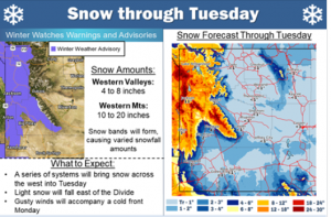
...Snow will return to the west today and tonight...
.Periods of light to moderate snow will return to the west late
this morning and continue through the overnight hours tonight.
Snow is expected to end by sunrise Tuesday morning.
Star Valley-Salt River and Wyoming Ranges-
Including the cities of Afton, Alpine, Star Valley Ranch,
and Thayne
137 AM MST Mon Feb 11 2019
...WINTER WEATHER ADVISORY IN EFFECT FROM NOON TODAY TO 7 AM MST
TUESDAY...
* WHAT...Snow expected. Total snow accumulations of 2 to 4 inches
expected in the Star Valley. Total snow accumulations of 4 to 8
inches expected in the Salt and Wyoming Ranges. Winds gusting as
high as 40 mph in the mountains.
* WHERE...Star Valley and Salt River and Wyoming Ranges.
* WHEN...From noon today to 7 AM MST Tuesday.
* ADDITIONAL DETAILS...Plan on slippery road conditions,
especially over Salt River Pass. Patchy blowing snow could
significantly reduce visibility. The hazardous conditions could
impact the morning and evening commutes.
PRECAUTIONARY/PREPAREDNESS ACTIONS...
A Winter Weather Advisory for snow means periods of snow will
cause primarily travel difficulties. Expect snow covered roads
and limited visibilities, and use caution while driving.
The latest road conditions for the state you are calling from can
be obtained by calling 5 1 1.
&&
