Public Information Statement
National Weather Service Riverton WY
423 PM MST Mon Feb 25 2019
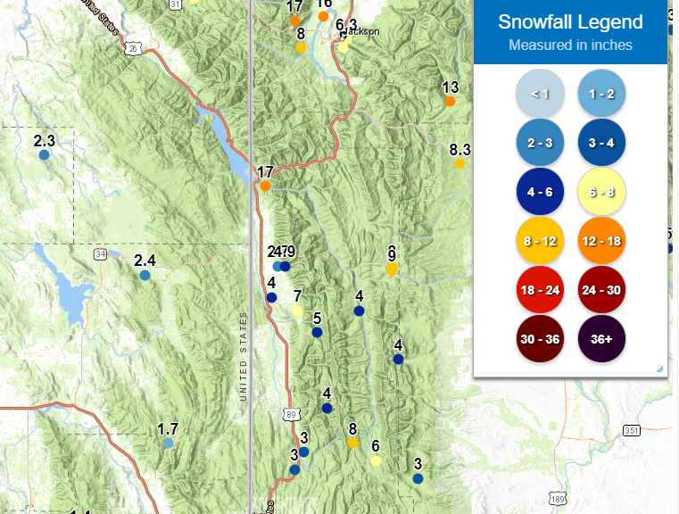
...Preliminary Snowfall Totals Through 3 PM Monday...
The following snowfall reports are preliminary winter storm totals
for western and northern Wyoming from 6 PM Saturday through 3 PM
Monday. Snow will continue through Tuesday and into Wednesday.
Some estimated totals have been corrected from a previous storm
report summary issued earlier Monday afternoon. Observations are
collected from a variety of sources with varying types of equipment
and exposures. We thank all of our volunteer weather observers for
their dedication. Not all data listed are considered official.
Note: SnoTELS (Snow Telemetry) are remote sensing sites in high
mountain watersheds. Snowfall data from SNOTELS are estimated based
on snow water equivalent.
Location Snowfall
Big Horn County...
Bald Mountain Snotel... 3 inches.
1 W Lovell... 2 inches.
Bone Springs Divide Snotel... 2 inches.
Shell Creek Snotel... 2 inches.
Greybull... 1.4 inches.
9 ENE Greybull... 1.1 inches.
2 SSW Lovell... 1 inch.
Deaver... 1 inch.
Fremont County...
Brooks Lake... 17 inches.
Burroughs Creek Snotel... 15 inches.
Castle Creek Snotel... 5 inches.
Little Warm Snotel... 3 inches.
South Pass Snotel... 3 inches.
Cold Springs Snotel... 2 inches.
Deer Park Snotel... 2 inches.
St. Lawrence Alt Snotel... 1 inch.
Townsend Creek Snotel... 1 inch.
Hobbs Park Snotel... 1 inch.
Hot Springs County...
Owl Creek Snotel... 4 inches.
6 N Thermopolis... 1.1 inches.
Thermopolis... 0.5 inches.
Johnson County...
Little Goose Snotel... 3 inches.
Soldier Park Snotel... 3 inches.
Hansen Sawmill Snotel... 2 inches.
17 E Kaycee... 1 inch.
Cloud Peak Reservoir Snotel... 1 inch.
Kaycee... 0.5 inches.
4 SSW Buffalo... 0.4 inches.
13 SSE Buffalo... 0.3 inches.
Buffalo... 0.2 inches.
Lincoln County...
Alpine... 17 inches.
Blind Bull Summit Snotel... 9 inches.
Commissary Ridge... 8 inches.
Blind Bull Summit... 8 inches.
3 SE Bedford... 7 inches.
Indian CreekSnotel... 7 inches.
Spring CreekDivideSnotel... 6 inches.
Willow CreekSnotel... 5 inches.
Star Valley Ranch... 4.9 inches.
Box Y Ranch... 4 inches.
2 SE Thayne... 4 inches.
5 SSE Smoot... 3 inches.
Kelley Ranger Station Snotel... 3 inches.
Salt River Summit Snotel... 2 inches.
Hams Fork Snotel... 1 inch.
Cottonwood CreekSnotel... 1 inch.
Afton... 0.2 inches.
Natrona County...
Reno Hill Snotel... 2 inches.
Park County...
Younts Peak Snotel... 18 inches.
Beartooth Lake Snotel... 15 inches.
Wolverine Snotel... 13 inches.
Kirwin Snotel... 11 inches.
Blackwater Snotel... 11 inches.
Evening Star Snotel... 10 inches.
Pahaska... 10 inches.
3 NE Clark... 7.1 inches.
Marquette Snotel... 4 inches.
Wapiti... 4 inches.
Cody... 2 to 4 inches.
Valley... 2.1 inches.
4 ENE Powell... 1.8 inches.
4 SW Powell... 1.5 inches.
Timber Creek Snotel... 1 inch.
Sublette County...
Bondurant... 8.3 inches.
Loomis Park Snotel... 7 inches.
Kendall Ranger Station Snotel... 7 inches.
Larsen Creek Snotel... 6 inches.
Elkhart Park G.S. Snotel... 5 inches.
East Rim Divide Snotel... 5 inches.
Pocket Creek Snotel... 5 inches.
New Fork Lake Snotel... 5 inches.
Triple Peak Snotel... 4 inches.
Snider Basin Snotel... 3 inches.
Big Sandy Opening Snotel... 3 inches.
Daniel Fish Hatchery... 2.1 inches.
Gunsite Pass Snotel... 2 inches.
Pinedale... 1 inch.
Sweetwater County...
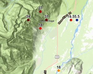
Teton County...
Jackson Hole - Rendezvous Bowl... 34 inches.
Jackson Hole - Mid Mountain... 31 inches.
Grassy Lake Snotel... 31 inches.
Jackson Hole - Raymer... 27 inches.
6 NW Moose... 20 inches.
1 ENE Teton Village... 19.5 inches.
Jackson Hole - Base... 18 inches.
Phillips Bench Snotel... 17 inches.
5 NW Jackson... 16 inches.
Grand Targhee Snotel... 16 inches.
Base Camp Snotel... 16 inches.
Grand Targhee - Chief Joseph... 15 inches.
Granite Creek Snotel... 13 inches.
Snake River Stn Snotel... 11 inches.
Togwotee Mountain Lodge... 9 inches.
Togwotee Pass Snotel... 8 inches.
3 SSW Wilson... 8 inches.
Jackson... 6.3 inches.
Snow King... 6 inches.
2 NE Teton Village... 5.5 inches.
Gros Ventre Summit Snotel... 5 inches.
1 NNW Alta... 1 inch.
Washakie County...
Powder River Pass Snotel... 1 inch.
8 SW Worland... 0.5 inches.
27 S Ten Sleep... 0.3 inches.
Ten Sleep... 0.1 inches.
Yellowstone National Park...
Two Ocean Plateau Snotel... 14 inches.
Lewis Lake Divide Snotel... 13 inches.
Parker Peak Snotel... 12 inches.
Thumb Divide Snotel... 11 inches.
Sylvan Lake Snotel... 10 inches.
Mammoth... 9.5 inches.
Canyon Snotel... 8 inches.
Yellowstone East Entrance... 7 inches.
Sylvan Road Snotel... 7 inches.
Tower Falls Ranger Station... 5 inches.
Lamar Ranger Station... 2.2 inches.
$$