 National Weather Service Riverton WY
313 PM MST Thu Mar 7 2019
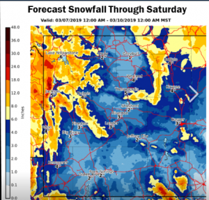
...A widespread area of significant accumulating snow is possible
over much of Central and Western Wyoming...
.A new Pacific weather system has the potential to dump significant
amounts of snowfall across much of Western and central Wyoming
Friday morning through Saturday morning.
Teton and Gros Ventre Mountains-Jackson Hole-
Wind River Mountains West-Star Valley-
Salt River and Wyoming Ranges-Upper Green River Basin Foothills-
South Lincoln County-
Including the cities of Jackson, Afton, Alpine,
Star Valley Ranch, Thayne, Pinedale, Kemmerer, and Cokeville
313 PM MST Thu Mar 7 2019
...WINTER STORM WATCH IN EFFECT FROM FRIDAY MORNING THROUGH
FRIDAY EVENING...
* WHAT...Heavy snow possible. Total snow accumulations of 3 to 6
inches in the valleys and 6 to 12 inches in the mountains
possible. There could be isolated higher snow amounts of 12 to
15 inches on the higher Teton Mountains. Winds could gust as
high as 35 mph.
* WHERE...Portions southwest and west central Wyoming.
* WHEN...From Friday morning through Friday evening.
* ADDITIONAL DETAILS...Plan on slippery road conditions. The
hazardous conditions could impact the evening commute.
PRECAUTIONARY/PREPAREDNESS ACTIONS...
A Winter Storm Watch means there is potential for significant
snow that may impact travel. Continue to monitor the latest
forecasts.
National Weather Service Riverton WY
313 PM MST Thu Mar 7 2019

...A widespread area of significant accumulating snow is possible
over much of Central and Western Wyoming...

.A new Pacific weather system has the potential to dump significant
amounts of snowfall across much of Western and central Wyoming
Friday morning through Saturday morning.

Teton and Gros Ventre Mountains-Jackson Hole-
Wind River Mountains West-Star Valley-
Salt River and Wyoming Ranges-Upper Green River Basin Foothills-
South Lincoln County-
Including the cities of Jackson, Afton, Alpine,
Star Valley Ranch, Thayne, Pinedale, Kemmerer, and Cokeville
313 PM MST Thu Mar 7 2019

...WINTER STORM WATCH IN EFFECT FROM FRIDAY MORNING THROUGH
FRIDAY EVENING...

* WHAT...Heavy snow possible. Total snow accumulations of 3 to 6
  inches in the valleys and 6 to 12 inches in the mountains
  possible. There could be isolated higher snow amounts of 12 to
  15 inches on the higher Teton Mountains. Winds could gust as
  high as 35 mph.

* WHERE...Portions southwest and west central Wyoming.

* WHEN...From Friday morning through Friday evening.

* ADDITIONAL DETAILS...Plan on slippery road conditions. The
  hazardous conditions could impact the evening commute.

PRECAUTIONARY/PREPAREDNESS ACTIONS...

A Winter Storm Watch means there is potential for significant
snow that may impact travel. Continue to monitor the latest
forecasts.
.....................................................................
National Weather Service Pocatello ID
132 PM MST Thu Mar 7 2019


Marsh and Arbon Highlands-Franklin/Eastern Oneida Region-
Bear River Range-Bear Lake Valley-Blackfoot Mountains-
Caribou Range-Big Hole Mountains-Teton Valley-
Centennial Mountains - Island Park-
Including the cities of Preston, Montpelier, Soda Springs, Henry,
Bone, Victor, Ashton, Driggs, and Island Park
132 PM MST Thu Mar 7 2019

...WINTER WEATHER ADVISORY REMAINS IN EFFECT FROM 5 AM FRIDAY TO
6 AM MST SATURDAY...

* WHAT...Snow expected. Plan on slippery road conditions,
  including during the morning commute on Friday. Total snow
  accumulations of 1 to 3 inches for the valleys south and east of
  the Snake Plain, including Bear Lake. For the mountains south
  and east of the Snake Plain, 3 to 7 inches. For Island Park, the
  Teton Valley and Big Holes, 3 to 6 inches in the valleys and 5
  to 10 inches in the mountains.

* WHERE...Malad, Emigration, Fish Creek, Georgetown, Border,
  Pine Creek and Targhee passes. Communities of Bear Lake,
  Preston, Soda Springs, Victor, Driggs and Island Park.

* WHEN...From 5 AM Friday to 6 AM MST Saturday.

* ADDITIONAL DETAILS...Be prepared for reduced visibilities at
  times. Patchy blowing snow is possible especially at or above
  pass level.

PRECAUTIONARY/PREPAREDNESS ACTIONS...

A Winter Weather Advisory for snow means periods of snow will
cause primarily travel difficulties. Be prepared for snow covered
roads and limited visibilities, and use caution while driving.
The latest road conditions can be obtained by calling 5 1 1.
