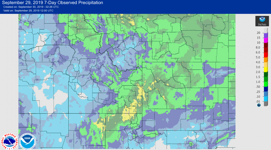
Storm Rainfall Summary September 27-29 2019
A very beneficial rainfall event soaked much of Western Wyoming and adjacent Idaho and Utah. Following are maps and listing of the reported rainfall amounts from the area.

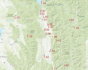
National Weather Service Riverton WY
743 PM MDT Sun Sep 29 2019

...Here are 48 hour Precipitation Totals ending at 6 PM MDT
Sunday September 29th...

Location                     Amount     Elevation (ft.)

...Yellowstone National Park...
Lake Yellowstone - YNP       0.82 in    7839
Lake - YNP                   0.70 in    7875
Mammoth                      0.68 in    6126
Snake Rvr Ranger Station - Y 0.64 in    6882
14 S Sylvan Pass - YNP       0.64 in    8649
Old Faithful - YNP           0.60 in    7319
1 SW Canyon - YNP            0.54 in    7899
3 W South Entrance YNP       0.52 in    7040
Tower Ranger Station - YNP   0.47 in    6266
1 N Mammoth - YNP            0.31 in    5624
Lamar Ranger Station - YNP   0.30 in    6604
15 WSW Mammoth               0.26 in    7899

...Wind River Mountains West...
19 WSW Dubois                1.88 in    8833
8 W South Pass City          1.17 in    8120
7 NE Pinedale                0.73 in    8529
9.3 N Boulder                0.67 in    7350
3 NW Atlantic City           0.56 in    8540

...Wind River Mountains East...
10 W Fort Washakie           1.24 in    9234
Union Pass                   1.02 in    8431
Sinks Canyon                 0.67 in    7083

...Wind River Basin...
6 WNW Fort Washakie          1.27 in    6120
1 SSE Fort Washakie          0.64 in    5564
Pavillion                    0.62 in    5485
10 SE Crowheart              0.56 in    5652
1 SE Riverton E              0.56 in    5043
Kinnear                      0.50 in    5413
12.9 NW Shoshoni             0.47 in    4760
3 NNW Hudson                 0.43 in    5555
Riverton Airport             0.40 in    5509
Riverton Forecast Office     0.39 in    5576
Riverton Downtown            0.39 in    4955
Riverton - CWC               0.30 in    5372
Boysen Reservoir             0.28 in    4708

...Upper Wind River Basin...
7 NW Dubois                  1.78 in    7188
Dubois                       1.48 in    7014
Crowheart                    1.23 in    6099

...Upper Green River Basin...
5.0 SE La Barge              0.80 in    6529
15 NNW Farson                0.53 in    6798
9 ENE Big Piney              0.49 in    6803
18.2 SE La Barge             0.47 in    6390
Big Piney Airport            0.41 in    6944
9 NW Marbleton               0.34 in    7176

...Upper Green River Basin Foothills...
2 NW Bondurant               1.32 in    6726
14 NW Pinedale               0.92 in    7464
10.6 N Daniel                0.86 in    7470
1 NNW Pinedale               0.59 in    7212
1 NE Pinedale                0.29 in    7310

...Teton and Gros Ventre Mountains...
B-T Portable No. 1           1.32 in    8500
16.0 E Kelly                 1.29 in    7312
17 N Alta                    0.84 in    6830
Alta                         0.31 in    6430

...Star Valley...
4 SSW Alpine                 2.32 in    5673
5 NNE Thayne                 2.28 in    6350
Star Valley Ranch            2.20 in    6692
2 SE Thayne                  2.16 in    6085
Etna                         1.87 in    5692
Thayne                       1.81 in    5948
3 N Etna                     1.80 in
Afton                        1.80 in    6245
5 SSE Smoot                  1.71 in    7004
1 SW Fairview                1.56 in    6218
Etna                         1.51 in    5823
Afton                        1.32 in    6267

...Southwest Big Horn Basin...
6 NNE Thermopolis            0.77 in    4433
8 NNE Thermopolis            0.75 in
Kirby                        0.66 in    4352
Thermopolis                  0.38 in    4425

...Southeast Johnson County...
Kaycee 17 NNW                1.08 in    5056
Kaycee                       0.64 in    5403
9 SW Kaycee                  0.64 in    4898
17 E Kaycee                  0.42 in
3.5 S Barnum                 0.19 in    5075

...Southeast Big Horn Basin...
Winchester                   0.83 in    4216
Ten Sleep                    0.79 in    4425
Ten Sleep                    0.62 in    4738
5 NNW Ten Sleep              0.60 in    4531
3 NE Worland                 0.56 in    4089
8 SW Worland                 0.53 in
1.8 SE Ten Sleep             0.51 in    4418
Worland Airport              0.50 in    4190
Worland                      0.46 in    4064
10 SSE Worland               0.41 in    4520
Ten Sleep                    0.35 in    4470

...South Lincoln County...
2 W Kemmerer                 0.36 in    6979
15.3 SW Calpet               0.32 in    6957

...Salt River and Wyoming Ranges...
B-T Portable No. 3           2.28 in    7799
Daniel 15.6 WNW              1.36 in    7720
15 NE Cokeville              0.99 in    8470
10.9 E Geneva                0.79 in    6649
12 E Cokeville               0.44 in    7458

...Rock Springs and Green River...
4 NNW Rock Springs           0.54 in    6497
2 SSE Green River            0.49 in    6060
1 E Rocks Springs            0.45 in
1 S Rock Springs             0.45 in    6266
8 E Little America           0.43 in    6129
Mckinnon                     0.23 in    7086

...Owl Creek and Bridger Mountains...
Anchor Dam                   1.45 in    6250
10 S Meeteetse               0.96 in    7126

...Northeast Johnson County...
13 SSE Buffalo               1.27 in    4818
Buffalo Airport              0.66 in    4905
Buffalo                      0.62 in    4370
6 W Buffalo                  0.54 in    5745
4 SE Story                   0.47 in    4662
8.2 S Story                  0.41 in    5278

...North Big Horn Basin...
9 ENE Geybull                1.40 in
Basin                        0.87 in    3897
Basin                        0.80 in    3820
1 ESE Burlington             0.77 in    4372
Greybull Airport             0.51 in    3935
Lovell                       0.45 in    3830
5 E Powell                   0.42 in
4 ENE Powell                 0.38 in    4287
4 SW Powell                  0.34 in    4485
1 W Powell                   0.31 in    4410
Frannie                      0.24 in    4274

...Natrona County Lower Elevations...
5 S Casper                   0.59 in
11 WSW Casper                0.43 in    5302
10 WSW Casper                0.41 in    5277
Bar Nunn                     0.40 in    5275
3 E Casper                   0.36 in    5318
7 S Casper                   0.36 in
Natrona County Airport       0.35 in    5348
1 NW Mills                   0.34 in    5209
1 NW Casper                  0.31 in    5141
17 SW Casper                 0.31 in    5364
1 S Casper                   0.30 in    5522
2 SW Casper                  0.30 in
1 SW Casper                  0.29 in    5314
Midwest                      0.02 in    4865

...Lander Foothills...
7 WNW Lander                 0.95 in    6041
4 SW Lander                  0.84 in    5768
6.1 SW Lander                0.79 in    6555
6 SW Lander                  0.76 in    6087
6 NW Lander                  0.73 in    5760
1 N Lander                   0.67 in    5352
1 SW Lander                  0.61 in    5456
Lander Airport               0.57 in    5565

...Jackson Hole...
2 NE Teton Village           1.51 in    6339
Moose                        1.44 in    6445
12 NE Jackson                1.42 in
Jackson                      1.37 in    6240
Jackson                      1.35 in    6210
4 N Moose                    1.26 in    6729
Hoback                       1.13 in    5928
Moran                        1.11 in    6800
Jackson Dam                  1.10 in    6776
7 E Moran Jct                1.05 in    7250
Jackson Airport              1.00 in    6450
3 W Wilson                   0.70 in

...Green Mountains and Rattlesnake Range...
7 SW Muddy Gap               0.63 in    7379
4 SW Sweetwater Station      0.52 in    6591
16 S Hiland                  0.37 in    6379
Independence Rock            0.26 in    5916
Jeffrey City                 0.22 in    6374

...Flaming Gorge...
2 NE Manila Utah             0.24 in    6060
18.7 NE Manila               0.23 in    6080

...East Sweetwater County...
15 SE Rock Springs           0.54 in    7549
4 NE Bitter Creek            0.46 in    6720
Rock Springs Airport         0.30 in    6745

...Cody Foothills...
Clark                        1.24 in    4658
Meeteetse                    0.67 in    5748
1 E Cody                     0.63 in    5070
2 NE Cody                    0.61 in    4939
1 SW Cody                    0.58 in    5139
Wapiti                       0.57 in    5398
2 WSW Cody                   0.56 in    5160
1 SE Cody                    0.51 in    5167
Cody                         0.51 in    5102
4 SE Cody                    0.50 in    5152
6 NE Cody                    0.50 in    4787
1 E Buffalo Bill Dam         0.47 in    5355
Cody Airport                 0.44 in    5138

...Casper Mountain...
5 SSW Casper                 0.59 in    6262

...Bighorn Mountains West...
30 E Greybull                0.63 in    8897
15 SSW Big Trails            0.54 in    6554
12 ENE Ten Sleep             0.53 in    8202
5 ENE Hyattville             0.44 in    5669

...Bighorn Mountains Foothills...

20 NW Mayoworth              0.75 in    8180
7 NW Mayoworth               0.74 in    5720
7 SW Barnum                  0.63 in    6439
18 NW Buffalo                0.50 in    8604
12 NE Lysite                 0.40 in
15 W Buffalo                 0.42 in    8398
15 WSW Story                 0.34 in    8292
15 SE Big Trails             0.22 in    7220
10 SW Story                  0.19 in    8580

...Absaroka Mountains...
32 SW Cody                   1.84 in    6200
14 NE Dubois                 1.08 in    7365
Pahaska                      0.84 in    6798
3 E Pahaska                  0.74 in    7500
10 WNW Cody                  0.69 in    8400
Shf2 - Portable              0.65 in    7156
Crandall                     0.36 in    6640
NE Entrance - YNP            0.31 in    7359

Observations are collected from a variety of sources with varying
equipment and exposures. We thank all volunteer weather observers
for their dedication. Not all data listed are considered official.

$$