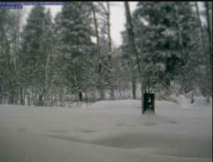
 Star Valley Ranch Snow Stake nearing 3 feet.
Public Information Statement...Updated
National Weather Service Riverton WY
219 PM MDT Mon Feb 3 2020

Snow spread across western and central Wyoming as a major winter
storm system marched across the region. The following are
preliminary snowfall totals through 11 AM Monday morning.

Location                              Snowfall

Big Horn County...
 Bone Springs Divide Snotel...        6 inches.
 Bald Mountain Snotel...              4 inches.
 Deaver...                            3 inches.
 Shell Creek Snotel...                3 inches.
 9 ENE Greybull...                  0.5 inches.
 2 SSW Lovell...                    0.2 inches.

Fremont County...
 Lander Airport...                 13.7 inches.
 6 SW Lander...                    11.4 inches.
 Lander...                         11.2 inches.
 3 SW Lander...                    10.5 inches.
 Hobbs Park Snotel...                10 inches.
 St. Lawrence Alt Snotel...          10 inches.
 7 WNW Lander...                     10 inches.
 1 N Lander...                       10 inches.
 9 S Lander...                      9.9 inches.
 9 SSE Lander...                    9.5 inches.
 Cold Springs Snotel...               9 inches.
 Townsend Creek Snotel...             9 inches.
 Hudson...                          8.5 inches.
 Atlantic City...                     8 inches.
 Brooks Lake...                       8 inches.
 1 S Riverton...                    7.8 inches.
 Deer Park Snotel...                  7 inches.
 South Pass Snotel...                 7 inches.
 4 W Riverton...                      7 inches.
 Riverton...                          7 inches.
 Riverton Airport...                6.2 inches.
 Burroughs Creek Snotel...            6 inches.
 Dubois...                            4 inches.
 Little Warm Snotel...                2 inches.

Hot Springs County...
 Owl Creek Snotel...                  7 inches.
 9 NE Thermopolis...                6.2 inches.
 6 N Thermopolis...                 5.5 inches.
 Kirby...                           3.1 inches.

Johnson County...
 13 SSE Buffalo...                   12 inches.
 Hansen Sawmill Snotel...             8 inches.
 Cloud Peak Reservoir Snotel...       7 inches.
 Little Goose Snotel...               7 inches.
 Buffalo...                          6.3 inches.
 4 SSW Buffalo...                      6 inches.
 17 E Kaycee...                       6 inches.
 Soldier Park Snotel...               6 inches.
 Buffalo...                          5.2 inches.
 Bear Trap Meadow Snotel...           3 inches.

Lincoln County...
 3 SE Bedford...                     12 inches.
 Afton...                            11 inches.
 Willow Creek Snotel...              10 inches.
 5 NNE Thayne...                      9 inches.
 Box Y Ranch...                       9 inches.
 2 SE Thayne...                     8.5 inches.
 Blind Bull Summit...                 8 inches.
 Blind Bull Summit Snotel...          8 inches.
 5 SSE Smoot...                       6 inches.
 Cottonwood Creek Snotel...           6 inches.
 Spring Creek Divide Snotel...        5 inches.
 Hams Fork Snotel...                  4 inches.
 Kelley Ranger Station Snotel...      4 inches.
 Alpine...                            4 inches.
 Indian Creek Snotel...               3 inches.
 Salt River Summit Snotel...          3 inches.
 Commissary Ridge...                  2 inches.

Natrona County...
 Casper Mountain...                  10 inches.
 10 WSW Casper...                     9 inches.
 4 WSW Casper...                    7.8 inches.
 Casper Airport...                  6.3 inches.
 Reno Hill Snotel...                  6 inches.
 Casper...                            6 inches.
 Grave Springs Snotel...              5 inches.
 Powder River...                      4 inches.

Park County...
 Wolverine Snotel...                 10 inches.
 Marquette Snotel...                  7 inches.
 Kirwin Snotel...                     7 inches.
 Evening Star Snotel...               7 inches.
 Timber Creek Snotel...               5 inches.
 3 NE Clark...                        4 inches.
 2 WSW Cody...                        4 inches.
 Blackwater Snotel...                 3 inches.
 Beartooth Lake Snotel...             3 inches.
 Younts Peak Snotel...                3 inches.
 3 NE Sunshine...                   2.6 inches.
 Meeteetse...                       2.5 inches.
 4 ENE Powell...                    2.3 inches.
 Cody...                              2 inches.
 Powell...                            2 inches.
 4 SW Powell...                     1.5 inches.
 Pahaska...                           1 inch.

Sublette County...
 Kendall Ranger Station Snotel...    10 inches.
 Merna...                            10 inches.
 East Rim Divide Snotel...           10 inches.
 Daniel Fish Hatchery...              9 inches.
 Loomis Park Snotel...                9 inches.
 New Fork Lake Snotel...              8 inches.
 1 N Pinedale...                      8 inches.
 Gunsite Pass Snotel...               8 inches.
 14 NW Pinedale...                  7.5 inches.
 Triple Peak Snotel...                6 inches.
 Pinedale...                          6 inches.
 Big Piney...                         5 inches.
 Snider Basin Snotel...               5 inches.
 Elkhart Park G.S. Snotel...          4 inches.
 Boulder Rearing Station...           4 inches.
 Big Sandy Opening Snotel...          2 inches.

Sweetwater County...
 4 NNW Rock Springs...              2.8 inches.
 Green River...                     2.5 inches.
 7 SE Rock Springs...               0.7 inches.
 1 W Green River...                 1.5 inches

Teton County...
 Granite Creek Snotel...              9 inches.
 Gros Ventre Summit Snotel...         8 inches.
 Jackson...                         7.5 inches.
 Togwotee Pass Snotel...              6 inches.
 6 NW Moose...                        6 inches.
 Base Camp Snotel...                  5 inches.
 Jackson Dam...                     4.2 inches.
 Snow King...                         4 inches.
 Jackson Hole - Rendezvous Bowl...    4 inches.
 Phillips Bench Snotel...             4 inches.
 Jackson Hole - Raymer...             4 inches.
 Jackson Hole - Mid Mountain...       3 inches.
 Grand Targhee - Chief Joseph...      3 inches.
 1 ENE Teton Village...               3 inches.
 5 NW Jackson...                    2.5 inches.
 Grand Targhee Snotel...              2 inches.
 Jackson Hole - Base...               2 inches.
 Togwotee Mountain Lodge...           2 inches.
 Snake River Stn Snotel...            2 inches.

Washakie County...
 16 SSE Ten Sleep...                  5 inches.
 5 NNW Ten Sleep...                 3.6 inches.
 Middle Powder Snotel...              3 inches.
 Powder River Pass Snotel...          2 inches.
 Winchester...                      1.7 inches.
 8 SW Worland...                    1.5 inches.

Yellowstone National Park...
 Lamar Ranger Station...             15 inches.
 Parker Peak Snotel...                5 inches.
 Tower Falls Ranger Station...      4.5 inches.
 Two Ocean Plateau Snotel...          4 inches.
 Thumb Divide Snotel...               4 inches.
 Canyon Snotel...                     4 inches.
 Sylvan Lake Snotel...                3 inches.
 Yellowstone East Entrance...         2 inches.
